
Ficheiro:Oceanic pole of inaccessibility.png

Dimensões desta antevisão: 600 × 600 píxeis. Outras resoluções: 240 × 240 píxeis | 480 × 480 píxeis | 960 × 960 píxeis.
Imagem numa resolução maior (960 × 960 píxeis, tamanho: 63 kB, tipo MIME: image/png)
|
|
Esta imagem provém do Wikimedia Commons, um acervo de conteúdo livre da Wikimedia Foundation que pode ser utilizado por outros projetos.
|
Descrição do ficheiro

|
Esta imagem de mapas (ou todas as imagens neste artigo ou categoria) deveriam ser recriadas usando gráficos vectoriais, como ficheiros SVG. Isto tem várias vantagens; veja as Commons:Media for cleanup|imagens para rever para mais informações. Se já criou um ficheiro SVG desta imagem, por favor, carregue-o. Depois do novo ficheiro SVG ter sido carregado, substitua aqui esta predefinição pela predefinição {{vector version available|nome da nova imagem.svg}}.
|
| Descrição |
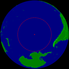
English: Spherical Earth centered on the oceanic pole of inaccessibility in the Southern Pacific ocean. The circle indicates the distance to the nearest landmasses (Antarctica, Easter Island and Ducie Island). The circle is deliberately a bit too small to ensure that the islands are still visible.
Deutsch: Erdkugel, zentriert auf dem ozeanischen Pol der Unzugänglichkeit im südlichen Pazifik. Der Kreis zeigt den Abstand zu den nächstgelegenen Landmassen (Antarktis, Osterinsel und Ducie). Der Kreis ist absichtlich ein wenig zu klein, damit die Inseln nicht verdeckt werden. |
| Data | |
| Origem | Obra do próprio |
| Autor | Timwi |
| Permissão (Reutilizar este ficheiro) |
Public domain |
Licenciamento
| Eu, titular dos direitos de autor desta obra, dedico-a ao domínio público, com aplicação em todo o mundo. Nalguns países isto pode não ser legalmente possível; se assim for: Concedo a todos o direito de usar esta obra para qualquer fim, sem quaisquer condições, a menos que tais condições sejam impostas por lei. |
Histórico do ficheiro
Clique uma data e hora para ver o ficheiro tal como ele se encontrava nessa altura.
| Data e hora | Miniatura | Dimensões | Utilizador | Comentário | |
|---|---|---|---|---|---|
| atual | 10h21min de 24 de março de 2015 | | 960 × 960 (63 kB) | RokerHRO | optipng -o7 -i0 → 28.12% decrease |
| 23h40min de 25 de julho de 2008 |  | 960 × 960 (88 kB) | Timwi | {{Information |Description= |Source= |Date= |Author= |Permission= |other_versions= }} | |
| 23h14min de 25 de julho de 2008 |  | 952 × 952 (38 kB) | Timwi | {{Information |Description={{en|1=Spherical Earth centered on the oceanic en:pole of inaccessibility in the Southern Pacific ocean. The circle indicates the distance to the nearest landmasses (en:Antarctica, en:Easter Island and [[en:Ducie |
Utilização local do ficheiro
As seguintes 3 páginas usam este ficheiro:
Utilização global do ficheiro
As seguintes wikis usam este ficheiro:
- ar.wikipedia.org
- ast.wikipedia.org
- az.wikipedia.org
- ca.wikipedia.org
- de.wikipedia.org
- en.wikipedia.org
- en.wikivoyage.org
- es.wikipedia.org
- et.wikipedia.org
- eu.wikipedia.org
- fa.wikipedia.org
- frr.wikipedia.org
- fr.wikipedia.org
- fr.wiktionary.org
- he.wikipedia.org
- hu.wikipedia.org
- id.wikipedia.org
- it.wikipedia.org
- ja.wikipedia.org
- lb.wikipedia.org
- lt.wikipedia.org
- nl.wikipedia.org
- nn.wikipedia.org
- no.wikipedia.org
- pl.wikipedia.org
- ro.wikipedia.org
- sk.wikipedia.org
- tr.wikipedia.org
- uk.wikipedia.org
- vi.wikipedia.org
- www.wikidata.org
- zh-classical.wikipedia.org
- zh.wikipedia.org
Ver mais utilizações globais deste ficheiro.