
Ficheiro:Rankin River.jpg

Dimensões desta antevisão: 800 × 534 píxeis. Outras resoluções: 320 × 213 píxeis | 640 × 427 píxeis | 1 024 × 683 píxeis.
Imagem numa resolução maior (1 024 × 683 píxeis, tamanho: 402 kB, tipo MIME: image/jpeg)
|
|
Esta imagem provém do Wikimedia Commons, um acervo de conteúdo livre da Wikimedia Foundation que pode ser utilizado por outros projetos.
|
Descrição do ficheiro
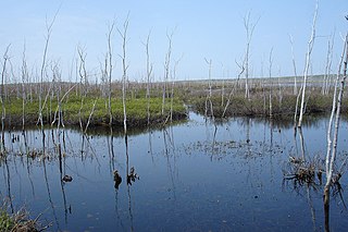
| Descrição | Located at the waist of the Bruce Peninsula, sections of the present day canoe route were utilized for hundreds of years by Indians traveling between Georgian Bay and Lake Huron. Missionaries and early settlers also used the route to avoid the long, perilous journey by water around the Bruce Peninsula. Lumbering reached the area in the 1860's. Square timber and saw logs were floated down the Rankin River to Lake Huron. Twenty years later, the steamer "Water Witch" towed rafts of saw logs from Sky, Isaac, and Boat Lakes towards the mill at Sauble Falls. In an attempt to reclaim possible agricultural land, a 1921 drainage project was abandoned when the soil was found to be unworkable. In 1961, the Sauble Valley Conservation Authority constructed a dam on the lower Rankin River to control the wildly fluctuating lake levels and to restore the valuable wetland habitat for increased wildlife potential. This trip is a must for anyone with an interest in viewing flora and fauna in its natural habitat. Basic canoeing or kayaking skill is recommended. |
| Data | |
| Origem |
|
| Autor | Jocelyn from Mississauga, Canada |
Licenciamento
A utilização deste ficheiro é regulada nos termos da licença Creative Commons - Atribuição 2.0 Genérica.
- Pode:
- partilhar – copiar, distribuir e transmitir a obra
- recombinar – criar obras derivadas
- De acordo com as seguintes condições:
- atribuição – Tem de fazer a devida atribuição da autoria, fornecer uma hiperligação para a licença e indicar se foram feitas alterações. Pode fazê-lo de qualquer forma razoável, mas não de forma a sugerir que o licenciador o apoia ou subscreve o seu uso da obra.
| Esta imagem, colocada originalmente no Flickr, foi revista em July 4, 2011 pelo administrador ou revisor File Upload Bot (Magnus Manske), que confirmou que ela estava disponível no Flickr naquela data com a licença declarada. |
Histórico do ficheiro
Clique uma data e hora para ver o ficheiro tal como ele se encontrava nessa altura.
| Data e hora | Miniatura | Dimensões | Utilizador | Comentário | |
|---|---|---|---|---|---|
| atual | 04h01min de 4 de julho de 2011 | | 1 024 × 683 (402 kB) | File Upload Bot (Magnus Manske) | {{Information |Description=Located at the waist of the Bruce Peninsula, sections of the present day canoe route were utilized for hundreds of years by Indians traveling between Georgian Bay and Lake Huron. Missionaries and early settlers also used the rou |
Utilização local do ficheiro
A seguinte página usa este ficheiro:
Utilização global do ficheiro
As seguintes wikis usam este ficheiro:
- ceb.wikipedia.org
- en.wikipedia.org
- www.wikidata.org