
Ficheiro:Smithisland milt.jpg

Dimensões desta antevisão: 549 × 600 píxeis. Outras resoluções: 220 × 240 píxeis | 439 × 480 píxeis | 703 × 768 píxeis | 1 024 × 1 119 píxeis.
Imagem numa resolução maior (1 024 × 1 119 píxeis, tamanho: 209 kB, tipo MIME: image/jpeg)
|
|
Esta imagem provém do Wikimedia Commons, um acervo de conteúdo livre da Wikimedia Foundation que pode ser utilizado por outros projetos.
|
Descrição do ficheiro
| Descrição |
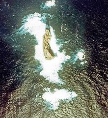
English: Aerial Photograph of Smith Island at Izu Islands in 1978.
日本語: 須美寿島の航空写真(1978年)。1990年代に島が部分的に崩落したため、現在とは形状が異なっている。 |
| Data | |
| Origem |
日本語: 国土画像情報(カラー空中写真) |
| Autor |
日本語: 国土交通省 |
Licenciamento

|
O titular dos direitos de autor deste ficheiro, the Ministry of Land, Infrastructure, Transport and Tourism of Japan, autoriza o seu uso por qualquer pessoa para qualquer finalidade, com a condição de que a sua autoria seja devidamente atribuída. A redistribuição, obras derivadas, uso comercial e todos os demais usos são permitidos. |
Atribuição:
Copyright © National Land Image Information (Color Aerial Photographs), Ministry of Land, Infrastructure, Transport and Tourism
|
 |
This image is copyrighted by the Ministry of Land, Infrastructure, Transport and Tourism of Japan. For terms of use, see the stipulation to use of National Land Information (in Japanese) and message from MLIT (in Japanese and English). When you display this image on an article, include the following phrase in the description: "Made based on National Land Image Information (Color Aerial Photographs), Ministry of Land, Infrastructure, Transport and Tourism".
|
Histórico do ficheiro
Clique uma data e hora para ver o ficheiro tal como ele se encontrava nessa altura.
| Data e hora | Miniatura | Dimensões | Utilizador | Comentário | |
|---|---|---|---|---|---|
| atual | 14h38min de 9 de maio de 2006 | | 1 024 × 1 119 (209 kB) | Tdk~commonswiki | Aerial Photograph of Smith Island at Izu Islands in 1978.{{AerialPhotograph-mlitJP}} |
Utilização local do ficheiro
A seguinte página usa este ficheiro:
Utilização global do ficheiro
As seguintes wikis usam este ficheiro:
- arz.wikipedia.org
- az.wikipedia.org
- ceb.wikipedia.org
- ckb.wikipedia.org
- cs.wikipedia.org
- de.wikipedia.org
- en.wikipedia.org
- es.wikipedia.org
- fa.wikipedia.org
- frr.wikipedia.org
- he.wikipedia.org
- hy.wikipedia.org
- it.wikipedia.org
- ja.wikipedia.org
- ko.wikipedia.org
- lt.wikipedia.org
- mr.wikipedia.org
- no.wikipedia.org
- ru.wikipedia.org
- sk.wikipedia.org
- tr.wikipedia.org
- uk.wikipedia.org
- www.wikidata.org
- zh.wikipedia.org