
Ficheiro:TV-introduction-world-map.svg

Dimensões desta antevisão em PNG do ficheiro SVG: 800 × 411 píxeis Outras resoluções: 320 × 164 píxeis | 640 × 329 píxeis | 1 024 × 526 píxeis | 1 280 × 657 píxeis | 2 560 × 1 314 píxeis | 863 × 443 píxeis.
Imagem numa resolução maior (ficheiro SVG, de 863 × 443 píxeis, tamanho: 1,59 MB)
|
|
Esta imagem provém do Wikimedia Commons, um acervo de conteúdo livre da Wikimedia Foundation que pode ser utilizado por outros projetos.
|
| Descrição |
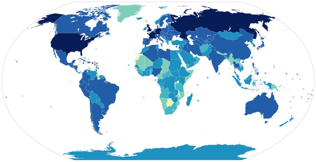
1939 and before
1940 to 1949
1950 to 1959
1960 to 1969
1970 to 1979
1980 to 1989
1990 to 1999
2000 and after
No television
No data |
||
| Data | |||
| Origem | Obra do próprio, using en:Image:BlankMap-World6.svg, with data from de:Liste der Länder nach Jahr der Einführung des Fernsehens. See there for the sources. | ||
| Autor | User:Laydan Mortensen | ||
| Permissão (Reutilizar este ficheiro) |
|
Histórico do ficheiro
Clique uma data e hora para ver o ficheiro tal como ele se encontrava nessa altura.
| Data e hora | Miniatura | Dimensões | Utilizador | Comentário | |
|---|---|---|---|---|---|
| atual | 18h45min de 10 de novembro de 2021 | | 863 × 443 (1,59 MB) | AngelChavezCo | Television in El Salvador started in 1956. |
| 05h18min de 14 de abril de 2018 |  | 863 × 443 (1,59 MB) | Howpper | Updated Western Sahara (sourced on article); Antarctica has had television since the 60's: https://books.google.com/books?id=L_L_VdtSxhcC&q=antarctica+television&dq=antarctica+television&hl=en&sa=X&ved=0ahUKEwibocOZgLnaAhUh3YMKHWcUA70Q6AEIMDAC http://java-tv.wikifoundry.com/page/Antarctica+Television+%281966-Present%29 | |
| 18h24min de 9 de maio de 2013 |  | 863 × 443 (1,59 MB) | Fry1989 | per talk | |
| 15h58min de 9 de maio de 2013 |  | 863 × 443 (1,55 MB) | Antemister | see talk page | |
| 01h15min de 27 de abril de 2013 |  | 863 × 443 (1,59 MB) | Fry1989 | South Sudan makes no sense as 2000s or later, they would have had television at the same time as Sudan as they were one country at the time | |
| 22h38min de 26 de abril de 2013 |  | 863 × 443 (1,55 MB) | Dewclouds | Edited Saudi-Yemen border, changed colour for no television, fixed 1990s/2000s colour error. | |
| 07h18min de 25 de abril de 2013 |  | 863 × 443 (1,55 MB) | Dewclouds | New colour palette. | |
| 06h07min de 24 de abril de 2013 |  | 863 × 443 (1,54 MB) | Dewclouds | New gradient colour scheme -- kindly ignore the last version, please. | |
| 05h34min de 24 de abril de 2013 |  | 863 × 443 (1,54 MB) | Dewclouds | New version with data from de:Liste der Länder nach Jahr der Einführung des Fernsehens. | |
| 08h35min de 29 de setembro de 2012 |  | 940 × 477 (862 kB) | Lcmortensen | Map recoloured to prevent clashing green colours and reduce red-green colour blindness. Still need to double check countries are the right colour per current data. |
Utilização local do ficheiro
A seguinte página usa este ficheiro:
Utilização global do ficheiro
As seguintes wikis usam este ficheiro:
- ba.wikipedia.org
- be-tarask.wikipedia.org
- de.wikipedia.org
- en.wikipedia.org
- en.wikiquote.org
- es.wikipedia.org
- et.wikipedia.org
- fa.wikipedia.org
- fiu-vro.wikipedia.org
- fi.wikipedia.org
- id.wikipedia.org
- ko.wikipedia.org
- ms.wikipedia.org
- pnb.wikipedia.org
- ro.wikipedia.org
- ru.wikipedia.org
- tt.wikipedia.org
- ug.wikipedia.org
- uk.wikipedia.org
- ur.wikipedia.org
- vep.wikipedia.org
- zh.wikipedia.org