
Ficheiro:The Old Town Hall - geograph.org.uk - 1042854.jpg
The_Old_Town_Hall_-_geograph.org.uk_-_1042854.jpg (640 × 426 píxeis, tamanho: 82 kB, tipo MIME: image/jpeg)
|
|
Esta imagem provém do Wikimedia Commons, um acervo de conteúdo livre da Wikimedia Foundation que pode ser utilizado por outros projetos.
|
Descrição do ficheiro
| Descrição |
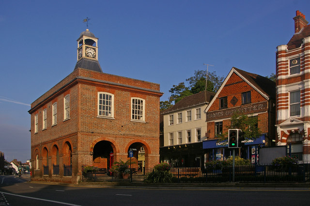
English: The Old Town Hall. This grade II* listed building (for listing particulars see http://www.heritagegateway.org.uk/Gateway/Results_Single.aspx?uid=289342&resourceID=5) was built in around 1728 as a replacement market hall for a similar building that once stood near West Street.
The cupola and clock were added in 1811 having been removed from the recently demolished nearby town prison ("the cage" - a new prison cage was built in what is now Cage Yard - see 1042857). In 1853, a chimney was added in each corner during alterations carried out by Lord Somers (who owned much of Reigate at the time) - they were removed in the 1980s, being out of keeping with the remainder of the building. It served as the town hall from 1863 to 1901, when the role transferred to the new municipal buildings in Castlefield Road (see 630757), after which it gained the name "Old Town Hall" by which it is now generally known. The building was used for petty court sessions from 1876, magistrates sitting there into the 1880s. It has been owned by the local council since 1922, with recent use including art and photographic exhibitions. However, following much debate over a longer term use to justify restoration, in 2008 it became a Caffe Nero coffee shop. Note the reference to a former user of the shop premises to the right of the building (now Carphone Warehouse) - Eames Outfitters; the building itself dates from the early 17th century and is grade II listed. |
| Data | |
| Origem | From geograph.org.uk |
| Autor | Ian Capper |
| Atribuição (requerido pela licença) | Ian Capper / The Old Town Hall / |
| Localização da câmara | | Esta e outras imagens nas suas localizações em: OpenStreetMap |
|---|
_heading:292.00&language=pt)
| Localização do objecto | | Esta e outras imagens nas suas localizações em: OpenStreetMap |
|---|
_heading:292.00&language=pt)
Licenciamento

|
Esta imagem foi tirada da coleção do projeto Geografia. Ver a página desta fotografia no website Geograph para detalhes de contato do fotógrafo. O direito autoral desta imagem pertence a Ian Capper e está licenciado para reuso sob a licença Creative Commons Atribuição-Compartilhamento pela mesma Licença.
|
- Pode:
- partilhar – copiar, distribuir e transmitir a obra
- recombinar – criar obras derivadas
- De acordo com as seguintes condições:
- atribuição – Tem de fazer a devida atribuição da autoria, fornecer uma hiperligação para a licença e indicar se foram feitas alterações. Pode fazê-lo de qualquer forma razoável, mas não de forma a sugerir que o licenciador o apoia ou subscreve o seu uso da obra.
- partilha nos termos da mesma licença – Se remisturar, transformar ou ampliar o conteúdo, tem de distribuir as suas contribuições com a mesma licença ou uma licença compatível com a original.
Histórico do ficheiro
Clique uma data e hora para ver o ficheiro tal como ele se encontrava nessa altura.
| Data e hora | Miniatura | Dimensões | Utilizador | Comentário | |
|---|---|---|---|---|---|
| atual | 22h41min de 23 de fevereiro de 2011 | | 640 × 426 (82 kB) | GeographBot | == {{int:filedesc}} == {{Information |description={{en|1=The Old Town Hall This grade II* listed building (for listing particulars see http://www.heritagegateway.org.uk/Gateway/Results_Single.aspx?uid=289342&resourceID=5) was built in around 1728 as a rep |
Utilização local do ficheiro
A seguinte página usa este ficheiro:
Utilização global do ficheiro
As seguintes wikis usam este ficheiro:
- azb.wikipedia.org
- en.wikipedia.org
- en.wikivoyage.org
- fa.wikipedia.org
- lt.wikipedia.org
- nl.wikipedia.org
- ru.wikipedia.org
- zh.wikipedia.org