
Ficheiro:Trinity crater.jpg
Dimensões desta antevisão: 754 × 599 píxeis. Outras resoluções: 302 × 240 píxeis | 604 × 480 píxeis | 966 × 768 píxeis | 1 280 × 1 017 píxeis | 2 560 × 2 035 píxeis | 7 880 × 6 263 píxeis.
Imagem numa resolução maior (7 880 × 6 263 píxeis, tamanho: 6,33 MB, tipo MIME: image/jpeg)
|
|
Esta imagem provém do Wikimedia Commons, um acervo de conteúdo livre da Wikimedia Foundation que pode ser utilizado por outros projetos.
|
| Descrição |
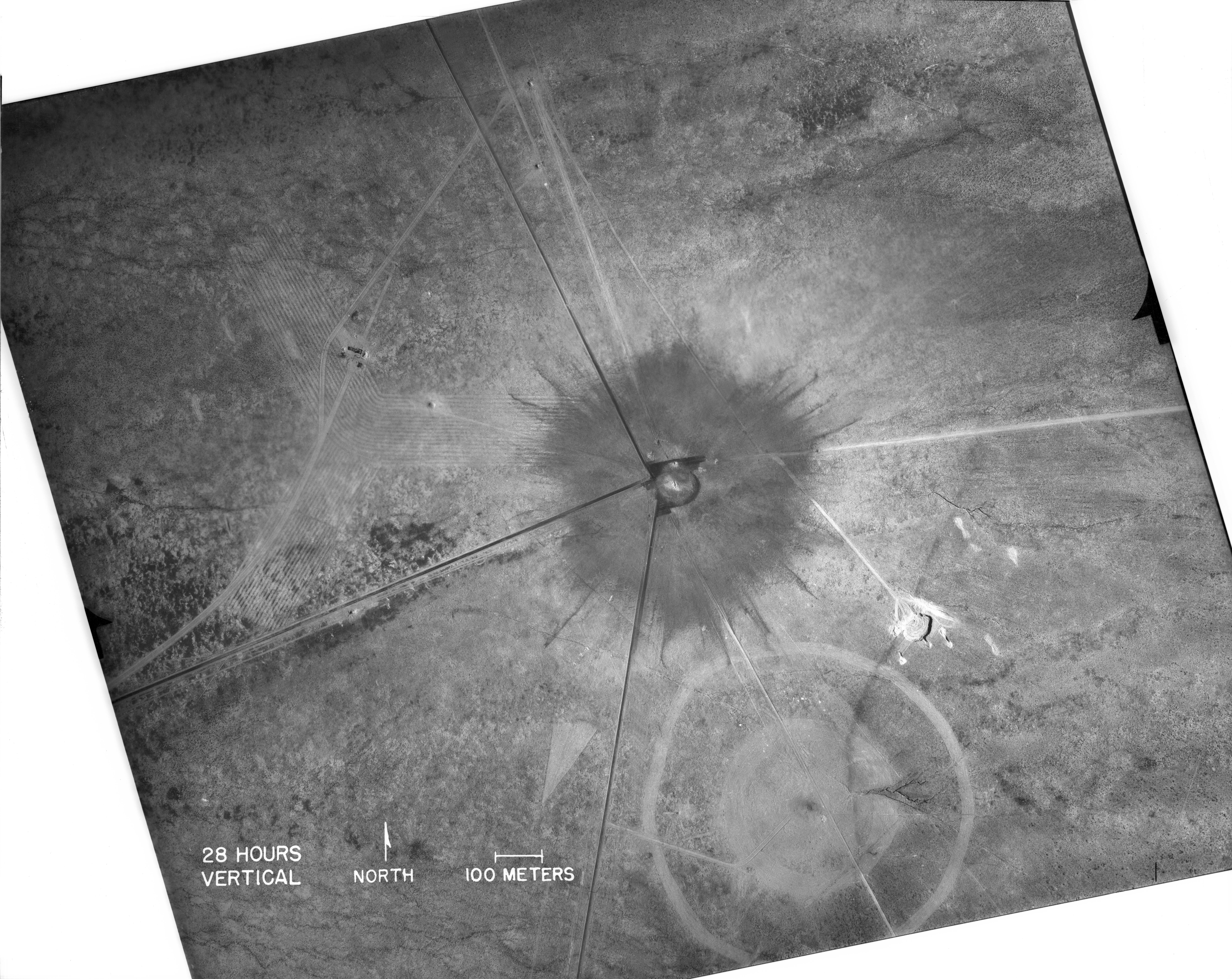
English: White Sands, New Mexico. Aerial view of the aftermath of the Trinity test, 28 hours after the explosion. The smaller crater to the southeast is from the earlier detonation of 100 tons of TNT on May 7, 1945. The dark straight lines are roads. To the left of the crater can be seen the "Jumbo" container, unharmed, and its collapsed tower (a vertical line). |
|
| Data | ||
| Origem |
|
|
| Autor | Federal government of the United States | |
| Outras versões |
|
.jpg)
_2.jpg)
| This image is a work of a United States Department of Energy (or predecessor organization) employee, taken or made as part of that person's official duties. As a work of the U.S. federal government, the image is in the public domain.
Please note that national laboratories operate under varying licences and some are not free. Check the site policies of any national lab before crediting it with this tag.
|

|
Histórico do ficheiro
Clique uma data e hora para ver o ficheiro tal como ele se encontrava nessa altura.
| Data e hora | Miniatura | Dimensões | Utilizador | Comentário | |
|---|---|---|---|---|---|
| atual | 16h03min de 1 de outubro de 2016 | | 7 880 × 6 263 (6,33 MB) | Quibik | Higher-res from https://www.flickr.com/photos/losalamosnatlab/19282799141/in/album-72157652920995393/ |
| 18h52min de 2 de dezembro de 2005 |  | 800 × 685 (190 kB) | Fastfission~commonswiki | better version | |
| 18h45min de 1 de setembro de 2005 |  | 472 × 315 (50 kB) | Fastfission~commonswiki | From en: Aerial view of the aftermath of the Trinity test. The smaller crater to the southeast is from the earlier detonation of 100 tons of TNT. Not sure about the scale but those dark straight lines are probably roads. Created as part of the [[Man |
Utilização local do ficheiro
A seguinte página usa este ficheiro:
Utilização global do ficheiro
As seguintes wikis usam este ficheiro:
- cs.wikipedia.org
- da.wikipedia.org
- fi.wikipedia.org
- ja.wikipedia.org
- ru.wikipedia.org
- sr.wikipedia.org
- www.wikidata.org