
Ficheiro:United States 1849-1850.png

Dimensões desta antevisão: 800 × 542 píxeis. Outras resoluções: 320 × 217 píxeis | 640 × 433 píxeis | 1 000 × 677 píxeis.
Imagem numa resolução maior (1 000 × 677 píxeis, tamanho: 95 kB, tipo MIME: image/png)
|
|
Esta imagem provém do Wikimedia Commons, um acervo de conteúdo livre da Wikimedia Foundation que pode ser utilizado por outros projetos.
|
Descrição do ficheiro
| Descrição |
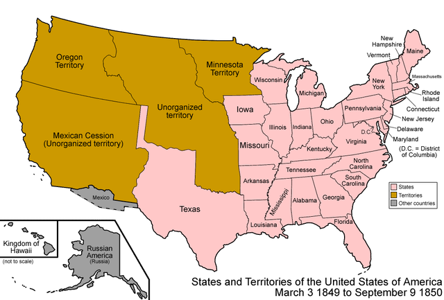
Map of the states and territories of the United States as it was from 1849 to 1850.
|
| Origem | Obra do próprio |
| Autor | Made by User:Golbez. See Charles O. Paullin and John K. Wright's Atlas of the Historical Geography of the United States (1932) for PD maps which support these. |
| Permissão (Reutilizar este ficheiro) |
Own work, attribution required (Multi-license with GFDL and Creative Commons CC-BY 2.5) |

|
Esta imagem de mapas (ou todas as imagens neste artigo ou categoria) deveriam ser recriadas usando gráficos vectoriais, como ficheiros SVG. Isto tem várias vantagens; veja as Commons:Media for cleanup|imagens para rever para mais informações. Se já criou um ficheiro SVG desta imagem, por favor, carregue-o. Depois do novo ficheiro SVG ter sido carregado, substitua aqui esta predefinição pela predefinição {{vector version available|nome da nova imagem.svg}}.
|
Licenciamento
Eu, titular dos direitos de autor desta obra, publico-a com as seguintes licenças:

|
É concedida permissão para copiar, distribuir e/ou modificar este documento nos termos da Licença de Documentação Livre GNU, versão 1.2 ou qualquer versão posterior publicada pela Free Software Foundation; sem Secções Invariantes, sem textos de Capa e sem textos de Contra-Capa. É incluída uma cópia da licença na secção intitulada GNU Free Documentation License. |
| A utilização deste ficheiro é regulada nos termos da licença Creative Commons - Atribuição-CompartilhaIgual 3.0 Não Adaptada. | ||
| ||
| Esta marca de licenciamento foi adicionada a este ficheiro durante a atualização da licença GFDL. |
A utilização deste ficheiro é regulada nos termos da licença Creative Commons - Atribuição 2.5 Genérica.
- Pode:
- partilhar – copiar, distribuir e transmitir a obra
- recombinar – criar obras derivadas
- De acordo com as seguintes condições:
- atribuição – Tem de fazer a devida atribuição da autoria, fornecer uma hiperligação para a licença e indicar se foram feitas alterações. Pode fazê-lo de qualquer forma razoável, mas não de forma a sugerir que o licenciador o apoia ou subscreve o seu uso da obra.
Pode escolher a licença que quiser.
| Territorial evolution maps of the United States |
| v · d (template shows date of beginning of change yyyy-mm-dd) |
| 1789-03, 1789-08, 1790-04, 1790-05, 1791-03, 1791-09, 1792-03, 1792-06, 1795, 1796, 1798, 1800-07-04, 1800-07, 1802, 1803-03, 1803-04, 1804-03, 1804-10, 1805-01, 1805-07, 1809, 1810-04, 1810-10, 1812-04, 1812-05, 1812-06, 1816, 1817-03, 1817-12, 1818-10, 1818-12, 1819-03, 1819-12, 1820, 1821-07, 1821, 1822, 1824, 1828, 1834, 1836-03, 1836-06, 1836-07, 1837-01, 1837-03, 1838, 1842, 1845-03, 1845-12, 1846-06, 1846-12, 1848-02, 1848-05, 1848-08, 1849, 1850, 1853-03, 1853-12, 1854, 1858, 1859, 1860, 1861-01, 1861-02-04, 1861-02-28, 1861-03, 1861-08, 1862, 1863-02, 1863-03, 1863-06, 1864-05, 1864-10, 1865, 1866, 1867-01, 1867-03, 1867-10, 1868, 1876, 1884, 1889-11-02, 1889-11-08, 1889-11-11, 1890-05, 1890-07-03, 1890-07-10, 1896-01, 1896-05, 1898, 1907, 1912-01, 1912-02, 1912-08, 1959-01, 1959-08 |
Histórico do ficheiro
Clique uma data e hora para ver o ficheiro tal como ele se encontrava nessa altura.
| Data e hora | Miniatura | Dimensões | Utilizador | Comentário | |
|---|---|---|---|---|---|
| atual | 07h04min de 29 de julho de 2006 | | 1 000 × 677 (95 kB) | Golbez | {{Information| |Description=Map of the states and territories of the United States as it was from |Source= |Date= |Author=Made by User:Golbez. |Permission=Own work, attribution required (Multi-license with GFDL and Creative Commons CC-BY 2.5) |other_ |
Utilização local do ficheiro
A seguinte página usa este ficheiro:
Utilização global do ficheiro
As seguintes wikis usam este ficheiro:
- ar.wikipedia.org
- bg.wikipedia.org
- ca.wikipedia.org
- cs.wikipedia.org
- da.wikipedia.org
- de.wikipedia.org
- en.wikipedia.org
- James K. Polk
- Compromise of 1850
- Henry Clay
- Sam Houston
- Southwestern United States
- Talk:List of U.S. states by date of admission to the Union
- Presidency of James K. Polk
- Presidency of Millard Fillmore
- Zachary Taylor
- Stephen A. Douglas
- History of United States foreign policy
- History of U.S. foreign policy, 1829–1861
- es.wikipedia.org
- fa.wikipedia.org
- fr.wikipedia.org
- he.wikipedia.org
- hy.wikipedia.org
- it.wikipedia.org
- ja.wikipedia.org
- nl.wikipedia.org
- no.wikipedia.org
- ru.wikipedia.org
- vi.wikipedia.org
- zh.wikipedia.org