
Ficheiro:Wfm rathlin.jpg

Dimensões desta antevisão: 800 × 593 píxeis. Outras resoluções: 320 × 237 píxeis | 640 × 474 píxeis | 1 024 × 758 píxeis | 1 280 × 948 píxeis.
Imagem numa resolução maior (1 280 × 948 píxeis, tamanho: 216 kB, tipo MIME: image/jpeg)
|
|
Esta imagem provém do Wikimedia Commons, um acervo de conteúdo livre da Wikimedia Foundation que pode ser utilizado por outros projetos.
|
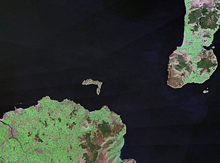
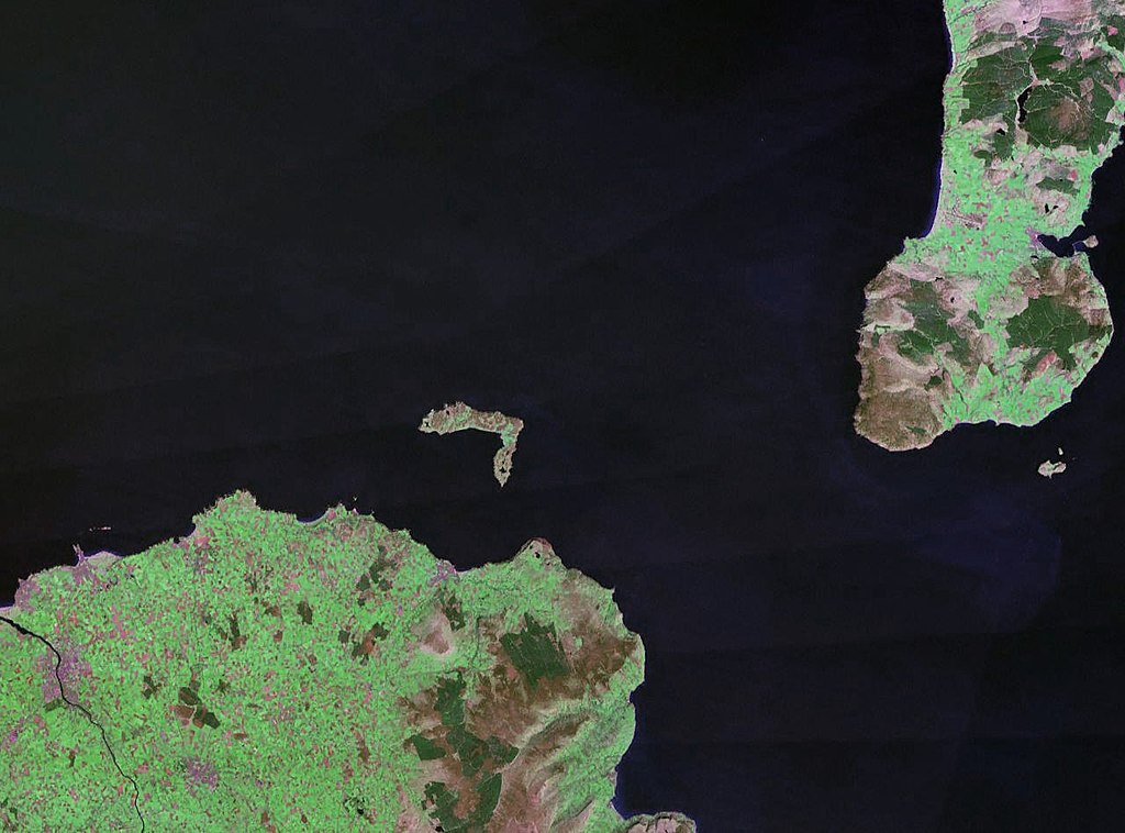
| Descrição | Rathlin Island in Northern Ireland. The coast of County Antrim is to the south, and the tip of the Kintyre Peninsula is to the east. |
| Data | cerca de 1990 |
| Origem |
NASA World Wind (landsat geocover 1990 data) Original image obtained fron NASA World Wind, colour and saturation tweaked with Adobe Photoshop. |
| Autor | NASA |
| Permissão (Reutilizar este ficheiro) |
USgov-PD |
| This image is in the public domain because it is a screenshot from NASA’s globe software World Wind using a public domain layer, such as Blue Marble, MODIS, Landsat, SRTM, USGS or GLOBE.
|
 |
Histórico do ficheiro
Clique uma data e hora para ver o ficheiro tal como ele se encontrava nessa altura.
| Data e hora | Miniatura | Dimensões | Utilizador | Comentário | |
|---|---|---|---|---|---|
| atual | 22h30min de 24 de abril de 2006 | | 1 280 × 948 (216 kB) | Finlay McWalter | {{Information| |Description=Rathlin Island |Source=NASA World Wind (landsat geocover 1990 data) |Date=c. 1990 |Author=NASA |Permission={{PD-WorldWind}} |other_versions= }} |
Utilização local do ficheiro
A seguinte página usa este ficheiro:
Utilização global do ficheiro
As seguintes wikis usam este ficheiro:
- af.wikipedia.org
- br.wikipedia.org
- ca.wikipedia.org
- ceb.wikipedia.org
- cs.wikipedia.org
- da.wikipedia.org
- de.wikipedia.org
- en.wikipedia.org
- eo.wikipedia.org
- es.wikipedia.org
- et.wikipedia.org
- eu.wikipedia.org
- fr.wikipedia.org
- ga.wikipedia.org
- gv.wikipedia.org
- hu.wikipedia.org
- ja.wikipedia.org
- kk.wikipedia.org
- lt.wikipedia.org
- nn.wikipedia.org
- no.wikipedia.org
- pl.wikipedia.org
- ru.wikipedia.org
- sv.wikipedia.org
- www.wikidata.org
- zh.wikipedia.org