
Ficheiro:Xinjiang Internment Map, US-Aus Gov Assessment.jpg
Dimensões desta antevisão: 800 × 495 píxeis. Outras resoluções: 320 × 198 píxeis | 640 × 396 píxeis | 1 024 × 634 píxeis | 1 280 × 792 píxeis | 2 048 × 1 267 píxeis.
Imagem numa resolução maior (2 048 × 1 267 píxeis, tamanho: 150 kB, tipo MIME: image/jpeg)
|
|
Esta imagem provém do Wikimedia Commons, um acervo de conteúdo livre da Wikimedia Foundation que pode ser utilizado por outros projetos.
|
Descrição do ficheiro
| Descrição |
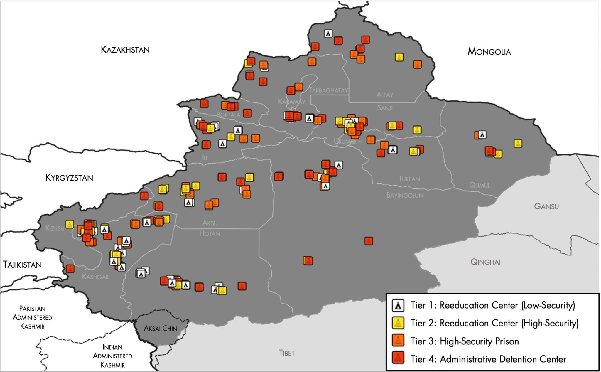
English: Map of the Xinjiang Internment Camps created by the RAND Corporation based on data collected by the US National Geospatial Intelligence Agency and the Australian Strategic Policy Institute. Open source here. |
||||||||
| Data | |||||||||
| Origem | https://www.tearline.mil/public_page/xinjiang-nighttime-1/ | ||||||||
| Autor | National Geospatial Intelligence Agency, using data from the Australian Strategic Policy Institute, and administrative boundaries from GADM. | ||||||||
| Permissão (Reutilizar este ficheiro) |
|


Histórico do ficheiro
Clique uma data e hora para ver o ficheiro tal como ele se encontrava nessa altura.
| Data e hora | Miniatura | Dimensões | Utilizador | Comentário | |
|---|---|---|---|---|---|
| atual | 05h05min de 2 de maio de 2021 | | 2 048 × 1 267 (150 kB) | Abovfold | Uploaded a work by {{w|National Geospatial Intelligence Agency}}, using data from the {{w|Australian Strategic Policy Institute}}, and administrative boundaries from {{w|GADM}}. from https://www.tearline.mil/public_page/xinjiang-nighttime-1/ with UploadWizard |
Utilização local do ficheiro
As seguintes 2 páginas usam este ficheiro:
Utilização global do ficheiro
As seguintes wikis usam este ficheiro:
- ba.wikipedia.org
- br.wikipedia.org
- cs.wikipedia.org
- de.wikipedia.org
- el.wikipedia.org
- en.wikipedia.org
- es.wikipedia.org
- fi.wikipedia.org
- fr.wikipedia.org
- ga.wikipedia.org
- he.wikipedia.org
- km.wikipedia.org
- nl.wikipedia.org
- or.wikipedia.org
- pl.wikipedia.org
- ru.wikinews.org
- sv.wikipedia.org
- szl.wikipedia.org
- tr.wikipedia.org
- www.wikidata.org