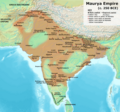
Ficheiro:Maurya Empire, c.250 BCE.png

O conteúdo da página não é suportado noutras línguas.
Origem: Wikipédia, a enciclopédia livre.

Imagem numa resolução maior(1 200 × 1 121 píxeis, tamanho: 2,3 MB, tipo MIME: image/png)

Descrição do ficheiro

Descrição

This is based on the map provided on p. 69 of Kulke, H.; Rothermund, D. (2004), A History of India, 4th, Routledge, ISBN 978-0-415-32920-0.

  • According to the authors, the empty areas within the boundaries of the empire were the "autonomous and free tribes".
  • For individual edicts, see also: Schwartzberg, J. E. (1992), A Historical Atlas of South Asia: University of Oxford Press; and https://en.wikipedia.org/wiki/List_of_Edicts_of_Ashoka
  • According to both Kulke & Rothermund (p. 68-71), as well as Stein (p. 74), large areas, especially in the Deccan peninsula, were probably occupied by fairly autonomous or even unconquered tribes.

    "Of course, it is not impossible that some may be still discovered but after more than a century of intensive research in this field it seems highly unlikely that the regional pattern mentioned above would have to be completely revised. This means that large parts of present Maharashtra and Andhra Pradesh as well as Kerala and Tamil Nadu were not actually included in the Maurya empire. South of the Vindhya mountains the Mauryas mainly controlled the coastal areas and some of the interior near present Mysore which they probably coveted because of the gold which was found there (Suvarnagiri means ‘gold mountain’). For the empire it was essential to control the major trade routes. Most important was certainly the northern route which led from Pataliputra through the Gangetic plain and the Panjab to Afghanistan. Another led from Pataliputra west via Kausambi and then along the northern slope of the Vindhya mountains via Vidisha (Sanchi) and Ujjain to the port of Bharukacha (Broach). There was a further route from there along the west coast to the area of present Bombay where the great rock edicts of Sopara were found. Southern parts could be reached along the east coast or via a central route from Ujjain via Pratishthana (Paithan near Aurangabad) to Suvarnagiri."

  • "The major part of the Deccan was ruled by [Mauryan administration]. But in the belt of land on either side of the Nerbudda, the Godavari and the upper Mahanadi there were, in all probability, certain areas that were technically outside the limits of the empire proper. Asoka evidently draws a distinction between the forests and the inhabiting tribes which are in the dominions (vijita) and peoples on the border (anta avijita) for whose benefit some of the special edicts were issued. Certain vassal tribes are specifically mentioned." (Raychaudhuri & Mukherjee pp. 275-6)
  • "Desert of Gedrosia [...] was left an unclaimed wilderness." —Kosmin, Paul J. (2014), The Land of the Elephant Kings Space, Territory, and Ideology in the Seleucid Empire, Harvard University Press, p.16
  • See also --Stein, Burton (1998). A History of India (1st ed.), Oxford: Wiley-Blackwell. --Raychaudhuri, H. C.; Mukherjee, B. N. (1996). Political History of Ancient India: From the Accession of Parikshit to the Extinction of the Gupta Dynasty. Oxford University Press.
  • Background from http://www2.demis.nl/mapserver/mapper.asp
  • Made with GIMP
Data
Origem Obra do próprio
Autor Avantiputra7

Licenciamento

Eu, titular dos direitos de autor desta obra, publico-a com a seguinte licença:
w:pt:Creative Commons
atribuição partilha nos termos da mesma licença
A utilização deste ficheiro é regulada nos termos da licença Creative Commons - Atribuição-CompartilhaIgual 3.0 Não Adaptada.
Pode:
  • partilhar – copiar, distribuir e transmitir a obra
  • recombinar – criar obras derivadas
De acordo com as seguintes condições:
  • atribuição – Tem de fazer a devida atribuição da autoria, fornecer uma hiperligação para a licença e indicar se foram feitas alterações. Pode fazê-lo de qualquer forma razoável, mas não de forma a sugerir que o licenciador o apoia ou subscreve o seu uso da obra.
  • partilha nos termos da mesma licença – Se remisturar, transformar ou ampliar o conteúdo, tem de distribuir as suas contribuições com a mesma licença ou uma licença compatível com a original.

Legendas

Adicione uma explicação de uma linha do que este ficheiro representa
India under Maurya rule c. 250 BCE

Histórico do ficheiro

Clique uma data e hora para ver o ficheiro tal como ele se encontrava nessa altura.

(Mais recentes | Mais antigas) Ver (10 posteriores | ) (10 | 20 | 50 | 100 | 250 | 500)
Data e horaMiniaturaDimensõesUtilizadorComentário
atual02h15min de 29 de janeiro de 2024Miniatura da versão das 02h15min de 29 de janeiro de 20241 200 × 1 121 (2,3 MB)Avantiputra7as per discussions added labelling of provinces
06h40min de 22 de novembro de 2023Miniatura da versão das 06h40min de 22 de novembro de 20231 200 × 1 121 (2,06 MB)Avantiputra7Reverted to version as of 05:59, 22 November 2023 (UTC) no justification for changing to less legible version of exactly the same map
06h14min de 22 de novembro de 2023Miniatura da versão das 06h14min de 22 de novembro de 20231 500 × 1 309 (2,93 MB)Indo12122Reverted to version as of 05:34, 22 November 2023 (UTC) Stop hijacking.
05h59min de 22 de novembro de 2023Miniatura da versão das 05h59min de 22 de novembro de 20231 200 × 1 121 (2,06 MB)Avantiputra7Reverted to version as of 05:06, 22 November 2023 (UTC)
05h34min de 22 de novembro de 2023Miniatura da versão das 05h34min de 22 de novembro de 20231 500 × 1 309 (2,93 MB)Indo12122Reverted to version as of 19:00, 21 November 2023 (UTC)
05h06min de 22 de novembro de 2023Miniatura da versão das 05h06min de 22 de novembro de 20231 200 × 1 121 (2,06 MB)Avantiputra7Reverted to version as of 18:13, 21 November 2023 (UTC) rv vandalism
19h00min de 21 de novembro de 2023Miniatura da versão das 19h00min de 21 de novembro de 20231 500 × 1 309 (2,93 MB)Indo12122Reverted to version as of 17:53, 21 November 2023 (UTC) Adding Gedrosia .Ray, Himanshu Prabha (2003). The Archaeology of Seafaring in Ancient South Asia. Cambridge University Press. ISBN 978-0-521-01109-9. In spite of the vagueness of the historical texts, the consensus among scholars is that the treaty concluded between Candragupta Maurya and Seleucus acknowledged Indian control of territories to the west of the Indus. These included Gedrosia, Paropamisadae (the region of Kabul and Begram) a...
18h13min de 21 de novembro de 2023Miniatura da versão das 18h13min de 21 de novembro de 20231 200 × 1 121 (2,06 MB)Avantiputra7Reverted to version as of 17:07, 21 November 2023 (UTC) no justification for changing to less legible version of exactly the same map
17h53min de 21 de novembro de 2023Miniatura da versão das 17h53min de 21 de novembro de 20231 500 × 1 309 (2,93 MB)Indo12122Reverted to version as of 16:58, 21 November 2023 (UTC)
17h07min de 21 de novembro de 2023Miniatura da versão das 17h07min de 21 de novembro de 20231 200 × 1 121 (2,06 MB)Avantiputra7Reverted to version as of 16:36, 21 November 2023 (UTC)
(Mais recentes | Mais antigas) Ver (10 posteriores | ) (10 | 20 | 50 | 100 | 250 | 500)

Não há nenhuma página que use este ficheiro.

Utilização global do ficheiro

Metadados