
Ficheiro:Swissmap.png
Imagem numa resolução maior (972 × 640 píxeis, tamanho: 456 kB, tipo MIME: image/png)
|
|
Esta imagem provém do Wikimedia Commons, um acervo de conteúdo livre da Wikimedia Foundation que pode ser utilizado por outros projetos.
|
From en:Image:Swissmap.png, mostly by en:User:Kokiri
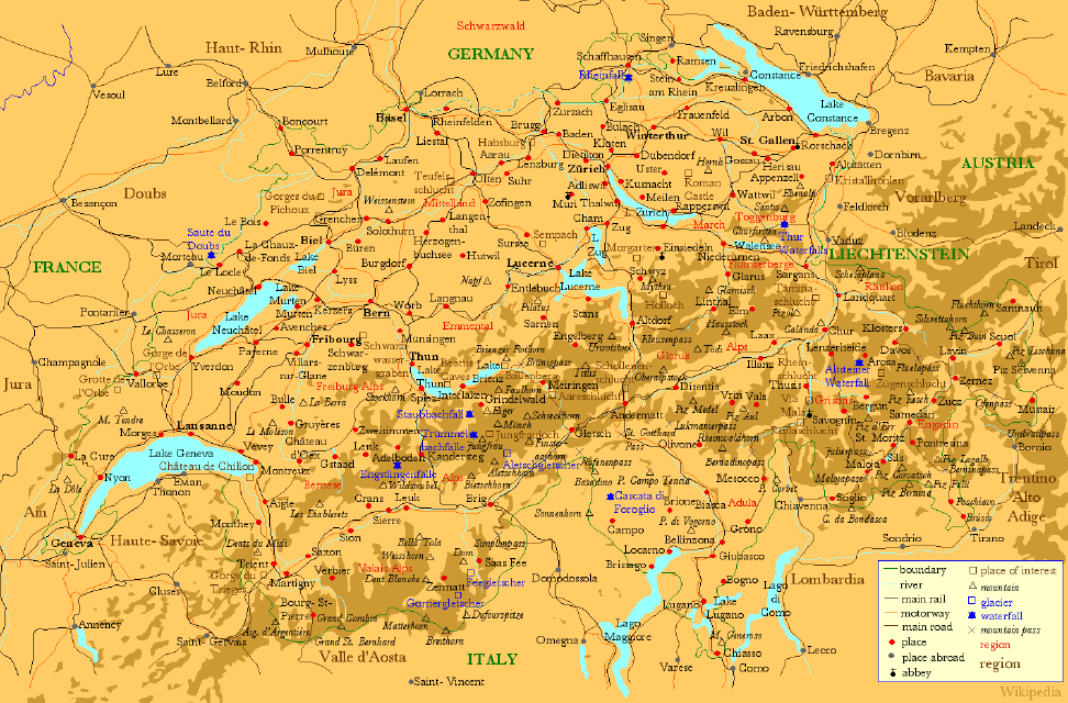
- Description: A map of Switzerland showing places in Switzerland (red) and the neighbouring areas (grey), large lakes (blue) , main rivers (blue), main railways (black), motorways (orange) and places of interest (brown).
- Source: Drawn myself.
New in version 2:
- rivers and lakes now light blue with dark blue labels
- 10 largest cities in bold
- national capitals underlined
- added two motorways around Lake Neuchâtel
- fixed a few inconsistencies and connection points
- removed the 'Battle' out of two historic battle sites
- rendered at a smaller scale for a smaller size
New in version 3:
- corrected spelling of Baden-Württemberg and Vorarlberg
- changed Schwarzwald into a region
- fixed a few inconsistencies
- moved a few names for better readability
New in version 4:
- corrected name of city at lake constance to constance (was Koblenz which is definitely wrong) (User:Andlaus)
New in version 5:
- added a basic relief showing mountains
- fixed some spelling mistakes
- cropped from larger version: Image:SwissmapFull.png, which is also available.

|
É concedida permissão para copiar, distribuir e/ou modificar este documento nos termos da Licença de Documentação Livre GNU, versão 1.2 ou qualquer versão posterior publicada pela Free Software Foundation; sem Secções Invariantes, sem textos de Capa e sem textos de Contra-Capa. É incluída uma cópia da licença na secção intitulada GNU Free Documentation License. |
| A utilização deste ficheiro é regulada nos termos da licença Creative Commons - Atribuição-CompartilhaIgual 3.0 Não Adaptada. | ||
| ||
| Esta marca de licenciamento foi adicionada a este ficheiro durante a atualização da licença GFDL. |
File history
Legend: (cur) = this is the current file, (del) = delete this old version, (rev) = revert to this old version. Click on date to download the file or see the image uploaded on that date. (del) (cur) 05:46, 11 June 2005 . . Kokiri (Talk | contribs) . . 972×640 (466,707 bytes) (New Version) (del) (rev) 04:02, 2 August 2004 . . Andlaus (Talk | contribs) . . 1167×767 (234,757 bytes) (corrected map of switzerland (koblenz->constance)) (del) (rev) 14:06, 17 April 2004 . . Kokiri (Talk | contribs) . . 1167×767 (165,508 bytes) (New verision of the large Swiss Map.) (del) (rev) 05:01, 31 March 2004 . . Kokiri (Talk | contribs) . . 1172×765 (168,489 bytes) (del) (rev) 22:30, 29 March 2004 . . Kokiri (Talk | contribs) . . 1560×1038 (252,608 bytes) (A Map of Switzerland, drawn myself.)
Histórico do ficheiro
Clique uma data e hora para ver o ficheiro tal como ele se encontrava nessa altura.
| Data e hora | Miniatura | Dimensões | Utilizador | Comentário | |
|---|---|---|---|---|---|
| atual | 10h30min de 29 de agosto de 2006 | | 972 × 640 (456 kB) | Maximaximax | From en:Image:Swissmap.png, mostly by en:User:Kokiri * Description: A map of Switzerland showing places in Switzerland (red) and the neighbouring areas (grey), large lakes (blue) , main rivers (blue), main railways (black), motorways (orang |
Utilização local do ficheiro
Não há nenhuma página que use este ficheiro.
Utilização global do ficheiro
As seguintes wikis usam este ficheiro:
- de.wikipedia.org
- eml.wikipedia.org
- en.wikipedia.org
- fr.wikipedia.org