
Ficheiro:Venezuela Division Politica Territorial.svg

Dimensões desta antevisão em PNG do ficheiro SVG: 781 × 600 píxeis Outras resoluções: 313 × 240 píxeis | 625 × 480 píxeis | 1 000 × 768 píxeis | 1 280 × 983 píxeis | 2 560 × 1 966 píxeis | 2 121 × 1 629 píxeis.
Imagem numa resolução maior (ficheiro SVG, de 2 121 × 1 629 píxeis, tamanho: 141 kB)
|
|
Esta imagem provém do Wikimedia Commons, um acervo de conteúdo livre da Wikimedia Foundation que pode ser utilizado por outros projetos.
|
| Descrição |
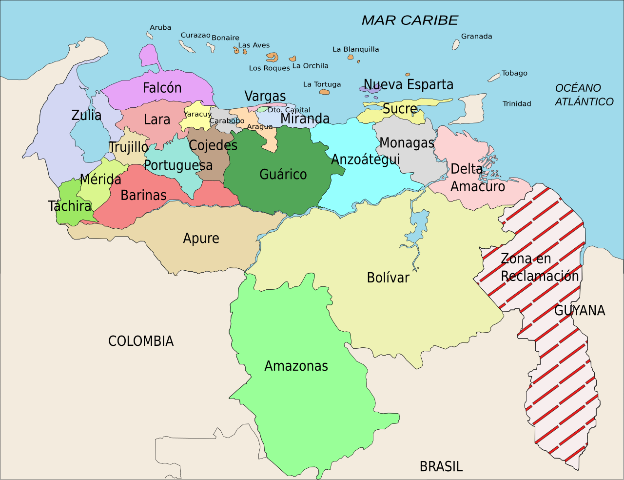
Español: División Político Territorial de Venezuela. Es un mapa acerca de los estados de Venezuela o división político territorial. La zona en reclamación aun no se sabe si pertenece a Guyana o a Venezuela, por eso se suele colocar de esa manera.
English: Political divisions of Venezuela. The Reclamation zone is Guyanan territory claimed by Venezuela. |
| Data | |
| Origem | self work, Image:Venezuela politica copy.png based |
| Autor | Wilfredor |
| Permissão (Reutilizar este ficheiro) |
Own work, copyleft: Multi-license with GFDL and Creative Commons CC-BY-SA-2.5 and older versions (2.0 and 1.0) |
| Outras versões |
Obras derivadas deste ficheiro: Venezuela Division Politica Territorial mk.svg
[]
|


Este(a) desenho vetorial não especificado foi criado com o Inkscape .
Eu, titular dos direitos de autor desta obra, publico-a com as seguintes licenças:

|
É concedida permissão para copiar, distribuir e/ou modificar este documento nos termos da Licença de Documentação Livre GNU, versão 1.2 ou qualquer versão posterior publicada pela Free Software Foundation; sem Secções Invariantes, sem textos de Capa e sem textos de Contra-Capa. É incluída uma cópia da licença na secção intitulada GNU Free Documentation License. |
| A utilização deste ficheiro é regulada nos termos da licença Creative Commons - Atribuição-CompartilhaIgual 3.0 Não Adaptada. | ||
| ||
| Esta marca de licenciamento foi adicionada a este ficheiro durante a atualização da licença GFDL. |
A utilização deste ficheiro é regulada nos termos da licença Creative Commons - Atribuição-CompartilhaIgual 2.5 Genérica, 2.0 Genérica e 1.0 Genérica.
- Pode:
- partilhar – copiar, distribuir e transmitir a obra
- recombinar – criar obras derivadas
- De acordo com as seguintes condições:
- atribuição – Tem de fazer a devida atribuição da autoria, fornecer uma hiperligação para a licença e indicar se foram feitas alterações. Pode fazê-lo de qualquer forma razoável, mas não de forma a sugerir que o licenciador o apoia ou subscreve o seu uso da obra.
- partilha nos termos da mesma licença – Se remisturar, transformar ou ampliar o conteúdo, tem de distribuir as suas contribuições com a mesma licença ou uma licença compatível com a original.
Pode escolher a licença que quiser.
Histórico do ficheiro
Clique uma data e hora para ver o ficheiro tal como ele se encontrava nessa altura.
| Data e hora | Miniatura | Dimensões | Utilizador | Comentário | |
|---|---|---|---|---|---|
| atual | 21h00min de 16 de abril de 2008 | | 2 121 × 1 629 (141 kB) | Wilfredor | {{Information |Description= '''(Spanish):''' División Político Territorial de Venezuela. Es un mapa acerca de los estados de Venezuela o división político territorial. La zona en reclamación aun no se sabe si pertenece a Guyana o a Venezuela, por es |
| 15h17min de 21 de abril de 2007 |  | 2 121 × 1 629 (140 kB) | Wilfredor | {{Information |Description= '''(Spanish):''' División Político Territorial de Venezuela. Es un mapa acerca de los estados de Venezuela o división político territorial. La zona en reclamación aun no se sabe si pertenece a Guyana o a Venezuela, por es | |
| 21h11min de 19 de abril de 2007 |  | 2 121 × 1 629 (135 kB) | Spundun | Reverted to earlier revision | |
| 21h10min de 19 de abril de 2007 |  | 2 119 × 1 629 (135 kB) | Spundun | Reverted to earlier revision | |
| 14h52min de 19 de abril de 2007 |  | 2 121 × 1 629 (135 kB) | Wilfredor | {{Information |Description= '''(Spanish):''' División Político Territorial de Venezuela </br> '''(English):''' Politic Territorial Division of Venezuela |Source=self work, Image:Venezuela politica copy.png based |Date=2007 |Author=[[user:wilfredo | |
| 00h33min de 18 de abril de 2007 |  | 2 119 × 1 629 (135 kB) | Wilfredor | {{Information |Description= '''(Spanish):''' División Político Territorial de Venezuela </br> '''(English):''' Politic Territorial Division of Venezuela |Source=self work |Date=2007 |Author=Wilfredo R. Rodriguez H. |Permission=Own wo | |
| 23h55min de 17 de abril de 2007 |  | 2 119 × 1 629 (124 kB) | Wilfredor | {{Information |Description= '''(Spanish):''' División Político Territorial de Venezuela </br> '''(English):''' Politic Territorial Division of Venezuela |Source=self work |Date=2007 |Author=Wilfredo R. Rodriguez H. |Permission=Own wo | |
| 20h56min de 17 de abril de 2007 |  | 2 160 × 1 664 (107 kB) | Wilfredor | {{Information |Description= '''(Spanish):''' División Político Territorial de Venezuela </br> '''(English):''' Politic Territorial Division of Venezuela |Source=self work |Date=2007 |Author=Wilfredo R. Rodriguez H. |Permission=Own wo | |
| 13h30min de 17 de abril de 2007 |  | 2 160 × 1 664 (88 kB) | Wilfredor | {{Information |Description= '''(Spanish):''' División Político Territorial de Venezuela </br> '''(English):''' Politic Territorial Division of Venezuela |Source=self work |Date=2007 |Author=Wilfredo R. Rodriguez H. |Permission=Own wo | |
| 02h54min de 17 de abril de 2007 |  | 2 160 × 1 664 (83 kB) | Wilfredor | {{Information |Description= '''(Spanish):''' División Político Territorial de Venezuela </br> '''(English):''' Politic Territorial Division of Venezuela |Source=self work |Date=2007 |Author=Wilfredo R. Rodriguez H. |Permission=Own wo |
Utilização local do ficheiro
As seguintes 2 páginas usam este ficheiro:
Utilização global do ficheiro
As seguintes wikis usam este ficheiro:
- an.wikipedia.org
- be.wikipedia.org
- br.wikipedia.org
- bs.wikipedia.org
- cs.wikipedia.org
- da.wikipedia.org
- de.wikipedia.org
- en.wikipedia.org
- es.wikipedia.org
- Categoría:Estados de Venezuela
- Wikiproyecto Discusión:Venezuela/1
- Categoría:Municipios de Venezuela
- Usuario:Dezulovic
- Anexo:Gobernadores de Venezuela
- Agua potable y saneamiento en Venezuela
- Categoría:Geografía de Venezuela por estado
- Categoría:Localidades de Venezuela por estado
- Wikiproyecto:Relaciones bilaterales/creados
- es.wikibooks.org
- es.wikinews.org
- fiu-vro.wikipedia.org
- fi.wikipedia.org
- frr.wikipedia.org
- fr.wikipedia.org
- Projet:Géographie/Palettes de navigation
- Modèle:Palette États du Venezuela
- États du Venezuela
- État de Bolívar
- État de La Guaira
- État de Táchira
- État de Lara
- État de Falcón
- État d'Yaracuy
- État de Carabobo
- État de Zulia
- État de Portuguesa
- État de Trujillo
- État de Cojedes
- État d'Aragua
- État d'Amazonas (Venezuela)
- État de Guárico
- État de Barinas
Ver mais utilizações globais deste ficheiro.