
Ficheiro:Heteralocha acutirostris distribution.png
Dimensões desta antevisão: 451 × 600 píxeis. Outras resoluções: 180 × 240 píxeis | 361 × 480 píxeis | 577 × 768 píxeis | 1 070 × 1 423 píxeis.
Imagem numa resolução maior (1 070 × 1 423 píxeis, tamanho: 135 kB, tipo MIME: image/png)
|
|
Esta imagem provém do Wikimedia Commons, um acervo de conteúdo livre da Wikimedia Foundation que pode ser utilizado por outros projetos.
|
Descrição do ficheiro
| Descrição |
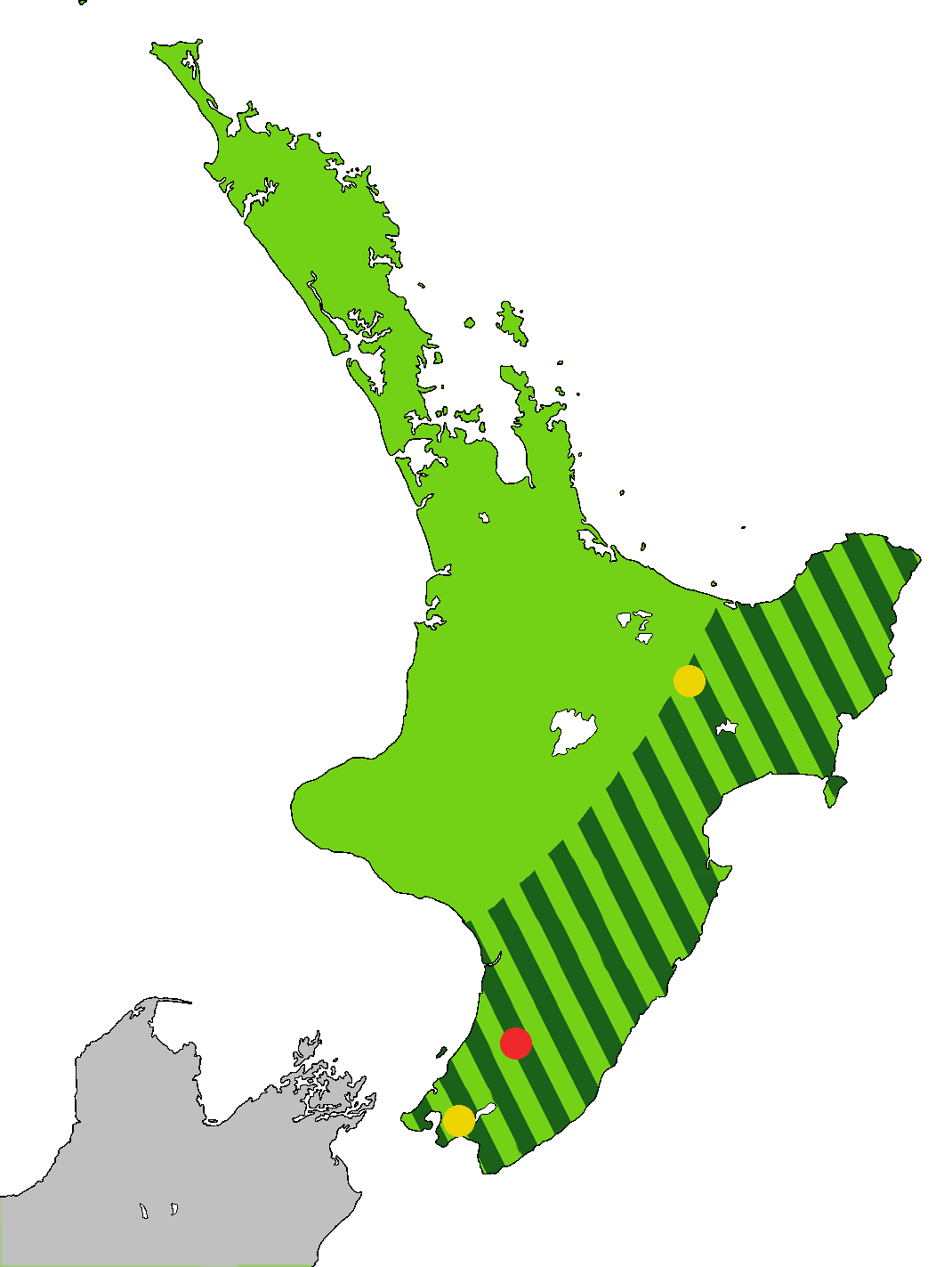
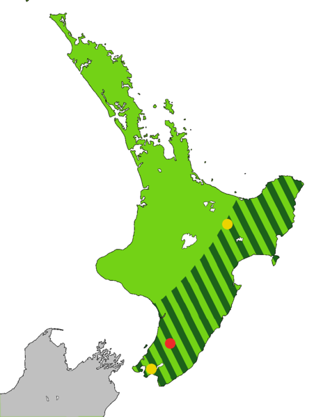
English: Light green: Range of the Huia, Heteralocha acutirostris, before the arrival of humans to New Zealand, as indicated by fossils. Dark green stripes: Range at 1840. Last sightings of the Huia: Red - last confirmed sighting in 1907 in Tararua Range. Yellow x 2 include one behind Eastbourne at the southern end of the North Island, and one in the Te Urewera National Park. The Huia is an extinct bird that was endemic to the North Island of New Zealand
Čeština: Laločník ostrozobý – distribuce. Světle zeleně: původní rozšíření laločníka ostrozobého; tmavě zelenými pruhy: rozsah druhu kolem roku 1840; červený bod: poslední potvrzené pozorování; žlutý bod: neověřená pozorování |
| Data | |
| Origem | Obra do próprio. Based on first version by Casliber with information provided by User:Kotare, using as a base for the outline File:New Zealand location map transparent.svg adapted by uploader User:Kahuroa |
| Autor | Kahuroa |
Licenciamento
| Esta obra foi dedicada ao domínio público pelo autor, Kahuroa, com aplicação em todo o mundo. Nalguns países isto pode não ser legalmente possível; se assim for: |
Histórico do ficheiro
Clique uma data e hora para ver o ficheiro tal como ele se encontrava nessa altura.
| Data e hora | Miniatura | Dimensões | Utilizador | Comentário | |
|---|---|---|---|---|---|
| atual | 18h36min de 14 de setembro de 2010 | | 1 070 × 1 423 (135 kB) | Kahuroa | Use new outline source: File:New Zealand location map transparent.svg adapted by uploader User:Kahuroa |
| 07h31min de 31 de agosto de 2010 |  | 1 760 × 2 346 (220 kB) | Kahuroa | New map - uses stripes to denote range in 1840 | |
| 21h46min de 21 de julho de 2010 |  | 449 × 599 (49 kB) | Casliber | {{Information |Description= |Source={{own}} |Date= |Author= Casliber |Permission= |other_versions= }} | |
| 21h04min de 21 de julho de 2010 |  | 449 × 599 (49 kB) | Casliber | {{Information |Description= Map added last sitings of the Huia. Red - last confirmed siting in 1907 in Tararua Range. Yellow x 2 include one behind Eastbourne, and one in the Te Urewera National Park. |Source={{own}} |Date= 23rd July 2010 |Author= [[User: | |
| 20h52min de 21 de julho de 2010 |  | 449 × 599 (48 kB) | Casliber | {{Information |Description={{en|1=Map of deforestation of North Island on New Zealand}} |Source={{own}} |Author=Casliber |Date=22nd July 2010 |Permission=yes |other_versions=no }} Category:Maps |
Utilização local do ficheiro
A seguinte página usa este ficheiro:
Utilização global do ficheiro
As seguintes wikis usam este ficheiro:
- ar.wikipedia.org
- bn.wikipedia.org
- ca.wikipedia.org
- ceb.wikipedia.org
- cs.wikipedia.org
- en.wikipedia.org
- es.wikipedia.org
- eu.wikipedia.org
- fa.wikipedia.org
- gl.wikipedia.org
- he.wikipedia.org
- hu.wikipedia.org
- it.wikipedia.org
- nn.wikipedia.org
- pl.wikipedia.org
- ru.wikipedia.org
- sr.wikipedia.org
- sv.wikipedia.org
- ta.wikipedia.org
- uk.wikipedia.org
- vi.wikipedia.org
- www.wikidata.org
- zh.wikipedia.org