
Ficheiro:Irene AMO 2005226 lrg.jpg

Imagem numa resolução maior (5 600 × 7 200 píxeis, tamanho: 6,23 MB, tipo MIME: image/jpeg)
|
|
Esta imagem provém do Wikimedia Commons, um acervo de conteúdo livre da Wikimedia Foundation que pode ser utilizado por outros projetos.
|
Descrição do ficheiro
| Descrição |
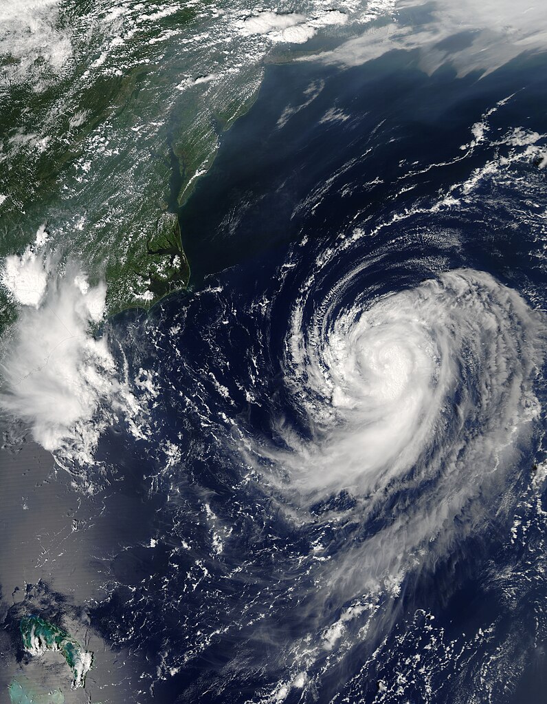
English: Irene was building towards a hurricane when the Moderate Resolution Imaging Spectroradiometer (MODIS) on NASA’s Aqua satellite captured this image at 2:20 p.m. U.S. Eastern Daylight Savings Time on August 14, 2005. By 11 p.m., Irene had become the third hurricane of the 2005 Atlantic hurricane season. The storm is moving northeast along the east coast of the United States and is not expected to make landfall, by National Hurricane Center predictions.
Along the top of the image, a pall of haze hugs the coast, blowing out over the Atlantic over the Chesapeake Bay. Such haze develops when hot, muggy weather caused by a high pressure system traps stagnant air. Emissions from cars and power plants build up, leading to hazy skies. The U.S. Environmental Protection Agency’s AirNow web site warned that air quality levels in the Mid-Atlantic states would be unhealthy for sensitive groups to unhealthy for all groups on August 13. Clearly, haze continued to affect the region on the following day. The large image provided above has a resolution of 500 meters per pixel. The MODIS Rapid Response Team provides the image in additional resolutions, including MODIS’ maximum resolution of 250 meters per pixel. |
| Data | |
| Origem | http://earthobservatory.nasa.gov/NaturalHazards/quarterly.php?cat_id=10&y=2005&q=3 |
| Autor | NASA; MODIS |
| Permissão (Reutilizar este ficheiro) |
Public domain |
Licenciamento
| Este ficheiro está no domínio público nos Estados Unidos porque foi criado exclusivamente pela NASA. As orientações sobre o direito de autor da NASA são que «as obras da NASA não têm os direitos de autor protegidos salvo indicação em contrário». Veja Template:PD-USGov, as orientações sobre o direito de autor da NASA ou as normas de uso de imagens do Laboratório de Propulsão a Jato (Jet Propulsion Lab, JPL). | ||
 |
Avisos:
|
Histórico do ficheiro
Clique uma data e hora para ver o ficheiro tal como ele se encontrava nessa altura.
| Data e hora | Miniatura | Dimensões | Utilizador | Comentário | |
|---|---|---|---|---|---|
| atual | 09h46min de 31 de julho de 2023 | | 5 600 × 7 200 (6,23 MB) | Nino Marakot | 250m resolution |
| 23h05min de 29 de dezembro de 2009 |  | 2 800 × 3 600 (2,46 MB) | Cyclonebiskit | {{Information |Description={{en|1=Irene was building towards a hurricane when the Moderate Resolution Imaging Spectroradiometer (MODIS) on NASA’s Aqua satellite captured this image at 2:20 p.m. U.S. Eastern Daylight Savings Time on August 14, 2005. By 1 |
Utilização local do ficheiro
A seguinte página usa este ficheiro:
Utilização global do ficheiro
As seguintes wikis usam este ficheiro:
- es.wikipedia.org
- tr.wikipedia.org
- uk.wikipedia.org
- www.wikidata.org
- zh.wikipedia.org