
Ficheiro:Kashmir Region (2020 skirmish locations).jpg
Dimensões desta antevisão: 604 × 599 píxeis. Outras resoluções: 242 × 240 píxeis | 484 × 480 píxeis | 774 × 768 píxeis | 1 033 × 1 024 píxeis | 1 579 × 1 566 píxeis.
Imagem numa resolução maior (1 579 × 1 566 píxeis, tamanho: 1,27 MB, tipo MIME: image/jpeg)
|
|
Esta imagem provém do Wikimedia Commons, um acervo de conteúdo livre da Wikimedia Foundation que pode ser utilizado por outros projetos.
|
.jpg)
Descrição do ficheiro
| Descrição |
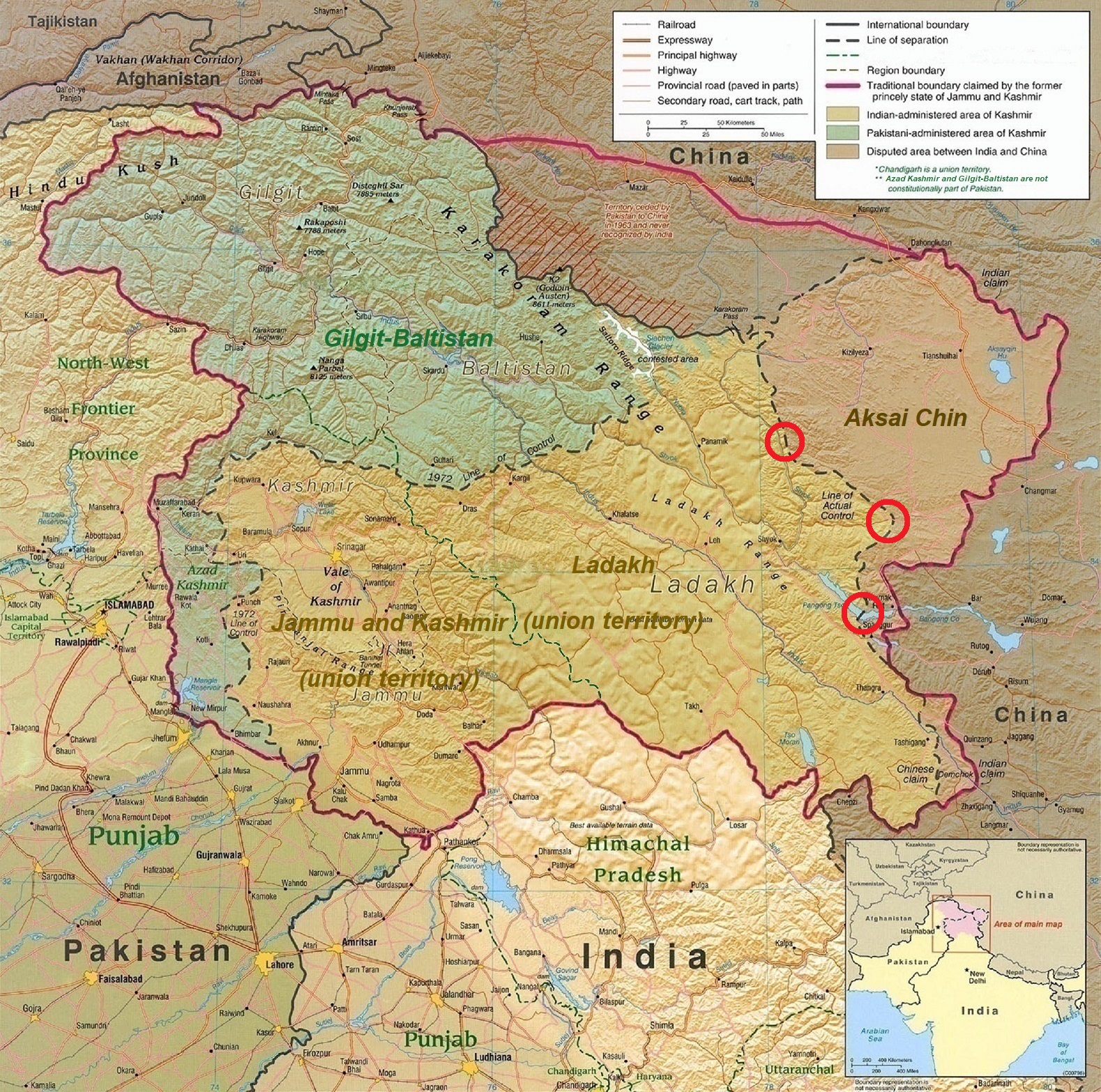
English: A map of the disputed Kashmir region created by the United States CIA in 2004 and hosted by the University of Texas at Austin Perry-Castañeda Library Map Collection; altered to show new jurisdictions by Fowler&fowler in November 2019; altered by to show 2020 skirmish locations by MarkH21 in June 2020. The red circles mark the rough locations of the conflicts at the the Galwan Valley (top), Hot Springs, Chang Chenmo Valley checkpoint (middle), and Pangong Tso (near the bottom). |
| Data | |
| Origem | Map of Kashmir region created by the US Central Intelligence Agency, 2004 |
| Autor | United States Central Intelligence Agency |
| Outras versões |
  |
Licenciamento
Esta obra encontra-se no domínio público nos Estados Unidos por ser uma obra do Governo Federal dos EUA nos termos do Título 17, Capítulo 1, Secção 105 do US Code. Veja Copyright.
Nota: Este estatuto apenas se aplica a obras do Governo Federal, e não a obras de nenhum estado, condado, subdivisão ou município.
|
 | |
| Este ficheiro foi considerado livre de restrições conhecidas devidas a direitos de autor, incluindo todos os direitos conexos. | ||
| Anotações | Esta imagem está anotada: Ver as anotações na wiki Commons |
Histórico do ficheiro
Clique uma data e hora para ver o ficheiro tal como ele se encontrava nessa altura.
| Data e hora | Miniatura | Dimensões | Utilizador | Comentário | |
|---|---|---|---|---|---|
| atual | 18h45min de 24 de junho de 2020 | | 1 579 × 1 566 (1,27 MB) | MarkH21 | Removed the Daulat Beg Oldi circle as not being an actual location of conflict; added the Hot Springs, Chang Chenmo Valley circle as an actual location of conflict. |
| 02h01min de 24 de junho de 2020 |  | 1 579 × 1 566 (1,27 MB) | MarkH21 | Uploaded a work by United States Central Intelligence Agency, MarkH21 from [https://legacy.lib.utexas.edu/maps/middle_east_and_asia/kashmir_region_2004.jpg Map of Kashmir region] created by the US Central Intelligence Agency, 2004; altered by MarkH21 with UploadWizard |
Utilização local do ficheiro
As seguintes 2 páginas usam este ficheiro:
Utilização global do ficheiro
As seguintes wikis usam este ficheiro:
- af.wikipedia.org
- ca.wikipedia.org
- en.wikipedia.org
- es.wikipedia.org
- fa.wikipedia.org
- fr.wikipedia.org
- he.wikipedia.org
- ja.wikipedia.org
- ka.wikipedia.org
- ml.wikipedia.org
- ne.wikipedia.org
- pnb.wikipedia.org
- ru.wikipedia.org
- simple.wikipedia.org
- so.wikipedia.org
- ta.wikipedia.org
- te.wikipedia.org
- th.wikipedia.org
- tr.wikipedia.org
- uk.wikipedia.org
- ur.wikipedia.org
- vi.wikipedia.org
- www.wikidata.org
- zh.wikipedia.org
.jpg)