
Ficheiro:Land shallow topo 2048.jpg

Dimensões desta antevisão: 800 × 400 píxeis. Outras resoluções: 320 × 160 píxeis | 640 × 320 píxeis | 1 024 × 512 píxeis | 1 280 × 640 píxeis | 2 560 × 1 280 píxeis | 21 600 × 10 800 píxeis.
Imagem numa resolução maior (21 600 × 10 800 píxeis, tamanho: 54,96 MB, tipo MIME: image/jpeg)
|
|
Esta imagem provém do Wikimedia Commons, um acervo de conteúdo livre da Wikimedia Foundation que pode ser utilizado por outros projetos.
|
Descrição do ficheiro
| Aviso | Alguns navegadores podem ter problemas ao exibir esta imagem em sua resolução máxima. Esta imagem tem um número excepcionalmente grande de píxeis e pode ou não carregar corretamente ou travar seu navegador. |
|---|
| Descrição |
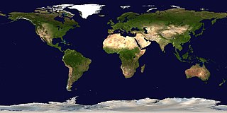
English: This spectacular “blue marble” image is the most detailed true-color image of the entire Earth to date. Using a collection of satellite-based observations, scientists and visualizers stitched together months of observations of the land surface, oceans, sea ice, and clouds into a seamless, true-color mosaic of every square kilometer (.386 square mile) of our planet. These images are freely available to educators, scientists, museums, and the public. This record includes preview images and links to full resolution versions up to 21,600 pixels across.
Much of the information contained in this image came from a single remote-sensing device-NASA’s Moderate Resolution Imaging Spectroradiometer, or MODIS. Flying over 700 km above the Earth onboard the Terra satellite, MODIS provides an integrated tool for observing a variety of terrestrial, oceanic, and atmospheric features of the Earth. The land and coastal ocean portions of these images are based on surface observations collected from June through September 2001 and combined, or composited, every eight days to compensate for clouds that might block the sensor’s view of the surface on any single day. Two different types of ocean data were used in these images: shallow water true color data, and global ocean color (or chlorophyll) data. Topographic shading is based on the GTOPO 30 elevation dataset compiled by the U.S. Geological Survey’s EROS Data Center. MODIS observations of polar sea ice were combined with observations of Antarctica made by the National Oceanic and Atmospheric Administration’s AVHRR sensor—the Advanced Very High Resolution Radiometer. The cloud image is a composite of two days of imagery collected in visible light wavelengths and a third day of thermal infra-red imagery over the poles. Global city lights, derived from 9 months of observations from the Defense Meteorological Satellite Program, are superimposed on a darkened land surface map. |
| Data | |
| Origem | https://visibleearth.nasa.gov/view.php?id=57752 (image link) |
| Autor | Reto Stöckli/NASA GSFC (land surface, shallow water, clouds); Robert Simmon (ocean color, compositing, 3D globes, animation); MODIS Land Group; MODIS Science Data Support Team; MODIS Atmosphere Group; MODIS Ocean Group; USGS EROS Data Center (topography); USGS Terrestrial Remote Sensing Flagstaff Field Center (Antarctica); Defense Meteorological Satellite Program (city lights). |
| Outras versões |
|
.jpg)
.jpg)
.png)

| 360° | View in 360° panoramic viewer
|
|---|
Licenciamento
| Este ficheiro está no domínio público nos Estados Unidos porque foi criado exclusivamente pela NASA. As orientações sobre o direito de autor da NASA são que «as obras da NASA não têm os direitos de autor protegidos salvo indicação em contrário». Veja Template:PD-USGov, as orientações sobre o direito de autor da NASA ou as normas de uso de imagens do Laboratório de Propulsão a Jato (Jet Propulsion Lab, JPL). | ||
 |
Avisos:
|
Histórico do ficheiro
Clique uma data e hora para ver o ficheiro tal como ele se encontrava nessa altura.
| Data e hora | Miniatura | Dimensões | Utilizador | Comentário | |
|---|---|---|---|---|---|
| atual | 02h08min de 16 de abril de 2017 | | 21 600 × 10 800 (54,96 MB) | Huntster | Full available resolution. |
| 15h31min de 14 de janeiro de 2006 |  | 2 048 × 1 024 (233 kB) | Haham hanuka~commonswiki | http://veimages.gsfc.nasa.gov//2433/land_shallow_topo_2048.jpg Category:Earth |
Utilização local do ficheiro
A seguinte página usa este ficheiro:
Utilização global do ficheiro
As seguintes wikis usam este ficheiro:
- ar.wikipedia.org
- el.wikipedia.org
- en.wikipedia.org
- en.wikibooks.org
- en.wikinews.org
- fi.wikibooks.org
- fr.wikipedia.org
- id.wikipedia.org
- pl.wikiquote.org
- so.wikipedia.org
- sr.wikipedia.org
- tl.wikipedia.org
- tr.wikipedia.org