
Ficheiro:Map of Central Asia with trade routes and movements, von Richthofen.png
Dimensões desta antevisão: 800 × 483 píxeis. Outras resoluções: 320 × 193 píxeis | 640 × 386 píxeis | 1 024 × 618 píxeis | 1 280 × 772 píxeis | 2 034 × 1 227 píxeis.
Imagem numa resolução maior (2 034 × 1 227 píxeis, tamanho: 4,8 MB, tipo MIME: image/png)
|
|
Esta imagem provém do Wikimedia Commons, um acervo de conteúdo livre da Wikimedia Foundation que pode ser utilizado por outros projetos.
|
Descrição do ficheiro
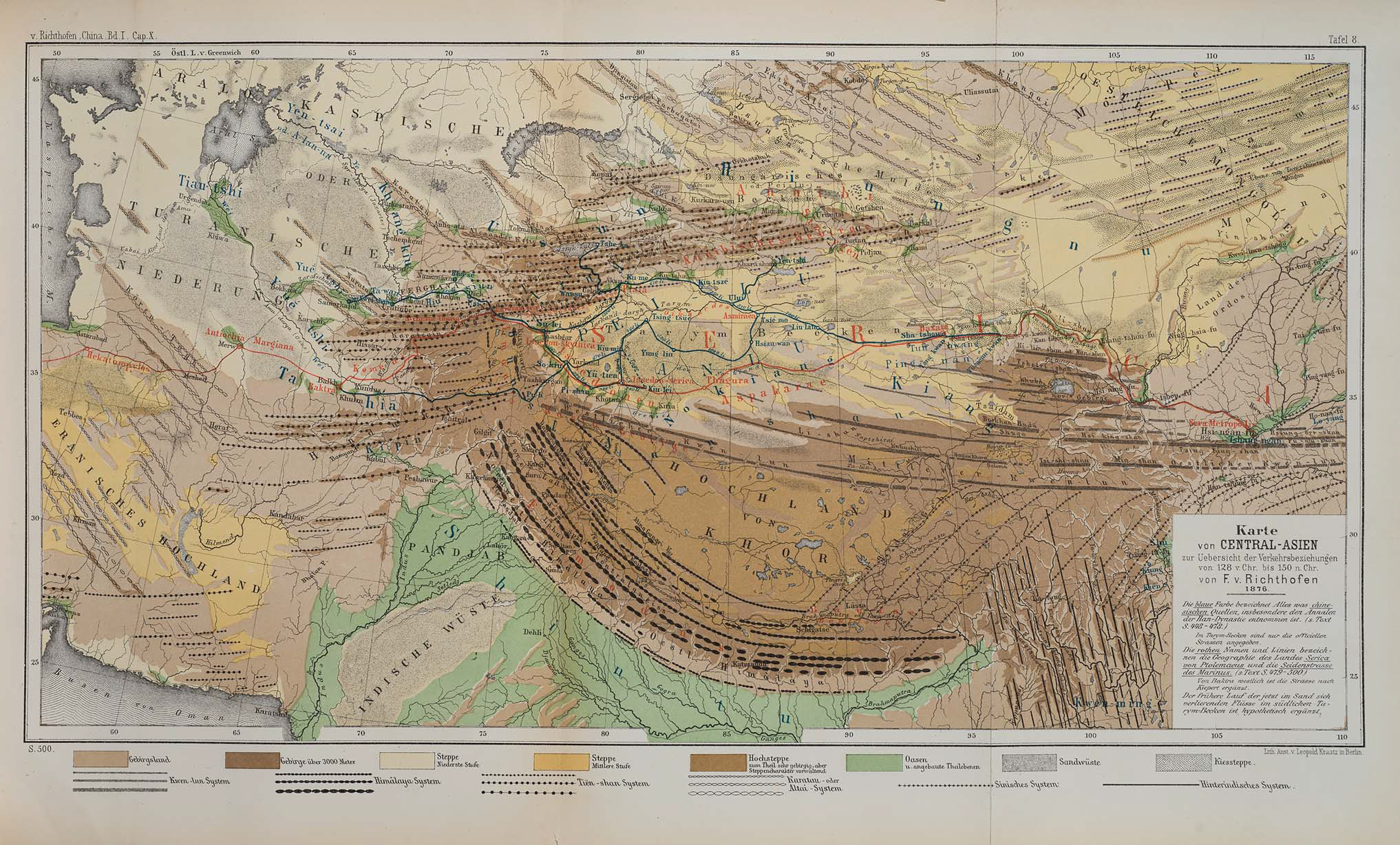
| Descrição | Map of Central Asia for overview of trade routes and movements from 128 BC to 150 AD |
| Data |
Dated 1876 Published 1877 |
| Origem |
F. von Richthofen (1877). China: Ergebnisse eigener Reisen und darauf gegründeter Studien. Band 1, Einleitender Theil [China: Expedition results and studies based thereupon. Volume 1, Introductory Part]. Berlin: Verlag von Dietrich Reimer. As reproduced in James D. Sidaway & Chih Yuan Woon (2017). Chinese Narratives on “One Belt, One Road” (一带一路) in Geopolitical and Imperial Contexts. The Professional Geographer 69(4), 591-603. doi: 10.1080/00330124.2017.1288576 |
| Autor | F. von Richthofen (1833–1905) |
| Outras versões |
.png)
Licenciamento
|
Esta obra está no domínio público no seu país de origem e noutros países e áreas onde o período de proteção dos direitos de autor é igual ou inferior à vida do autor mais 100 anos. | |
| Este ficheiro foi considerado livre de restrições conhecidas devidas a direitos de autor, incluindo todos os direitos conexos. | |
| Anotações | Esta imagem está anotada: Ver as anotações na wiki Commons |
Histórico do ficheiro
Clique uma data e hora para ver o ficheiro tal como ele se encontrava nessa altura.
| Data e hora | Miniatura | Dimensões | Utilizador | Comentário | |
|---|---|---|---|---|---|
| atual | 08h14min de 24 de novembro de 2018 | | 2 034 × 1 227 (4,8 MB) | Cold Season | {{Information |Description= Map of Central Asia for overview of trade routes and movements. |Source= Von Richthofen, F. (1877). ''China: Ergebnisse eigener Reisen und darauf gegründeter Studien''. Band 1, Einleitender Theil [China: Expedition results and studies based thereupon. Volume 1, Introductory Part]. Berlin: Verlag von Dietrich Reimer. As reproduced in James D. Sidaway & Chih Yuan Woon (2017) Chinese Narratives on “One Belt, One Road” (一带一路) in Geopolitical and Imperial Contexts, ''T... |
Utilização local do ficheiro
A seguinte página usa este ficheiro:
Utilização global do ficheiro
As seguintes wikis usam este ficheiro:
- en.wikipedia.org
- et.wikipedia.org
- fa.wikipedia.org
- he.wikipedia.org
- ko.wikipedia.org
- sl.wikipedia.org
- th.wikipedia.org