
Ficheiro:North america terrain 2003 map.jpg

Imagem numa resolução maior (3 300 × 2 938 píxeis, tamanho: 1,66 MB, tipo MIME: image/jpeg)
|
|
Esta imagem provém do Wikimedia Commons, um acervo de conteúdo livre da Wikimedia Foundation que pode ser utilizado por outros projetos.
|
|
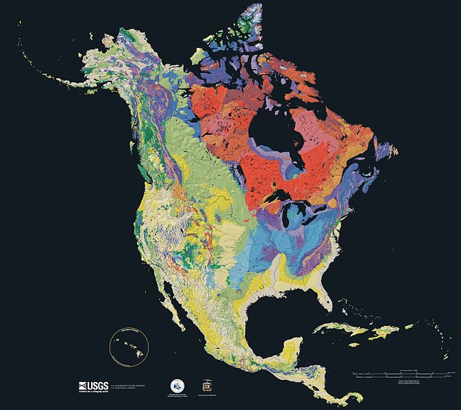
Relief map showing the varying age of bedrock underlying North America.

This cartographic tapestry is woven from a geologic map and a shaded relief image. This combination reveals the geologic history of North America through the interrelation of rock type, topography and time. Regional surface processes as well as continent-scale tectonic events are exposed in the three dimensions of space and the fourth dimension, geologic time.
From most recent to oldest, age is indicated by: yellow, green, blue, red.

The fuchsia U-shape of the Canadian Shield is clearly apparent. The base of ancient mountains and impact craters, this mineral-rich rock is nearly bare due to recent ice ages.

The Canadian Shield is an exposed part of the North American craton, a stable area which extends down the continent along the blue areas, and includes the sweep east of the Rocky Mountains back northward along the pale yellows of the Great Plains, light green across Wyoming and nearly to Alaska.
Rock types
Four maps show the North American distribution of four principal types of rock: sedimentary, volcanic, plutonic and metamorphic rock.


Source

The North America Tapestry of Time and Terrain (1:8,000,000 scale) is a product of the United States Geological Survey in the I-map series (I-2781). This map was prepared in collaboration with the Geological Survey of Canada and the Mexican Consejo Recursos de Minerales[1] cópia arquivada at the Wayback Machine.
Home: http://pubs.usgs.gov/imap/i2781/
Image: http://pubs.usgs.gov/imap/i2781/i2781_c_low.pdf 144 dpi, encoded to 72 dpi JPEG, compressed slightly to fit within Wikipedia 2MB limit.
English Wikipedia, original upload 15 April 2005 by SEWilco
Esta imagem está no domínio público porque ela contém materiais originalmente provenientes do Serviço Geológico dos Estados Unidos, uma agência do Departamento do Interior dos Estados Unidos. Para mais informações, veja a política oficial da USGS em relação a direitos autorais
|
| Anotações | Esta imagem está anotada: Ver as anotações na wiki Commons |
Histórico do ficheiro
Clique uma data e hora para ver o ficheiro tal como ele se encontrava nessa altura.
| Data e hora | Miniatura | Dimensões | Utilizador | Comentário | |
|---|---|---|---|---|---|
| atual | 15h21min de 16 de setembro de 2005 | | 3 300 × 2 938 (1,66 MB) | Saperaud~commonswiki | Relief map showing the varying age of bedrock underlying North America. thumb|150px|right|Time scale for [[:Image:North america terrain 2003 map.jpg|North America terrain ]] This cartographic t |
Utilização local do ficheiro
A seguinte página usa este ficheiro:
Utilização global do ficheiro
As seguintes wikis usam este ficheiro:
- af.wikipedia.org
- ar.wikipedia.org
- arz.wikipedia.org
- bn.wikipedia.org
- de.wikipedia.org
- el.wikipedia.org
- en.wikipedia.org
- North America
- User:SEWilco
- Geologic map
- User:SEWilco/Images
- Wikipedia:Featured picture candidates/April-2005
- Wikipedia:Picture of the day/June 2005
- Wikipedia:Featured picture candidates/North america terrain 2003 map.jpg
- Wikipedia:Featured pictures thumbs/02
- Wikipedia:Wikipedia Signpost/2005-05-02/Features and admins
- Wikipedia:POTD/June 19, 2005
- Wikipedia:Picture of the day/June 19, 2005
- History of Earth
- User:Cyde/Featured pictures
- Portal:North America/Selected picture
- Portal:Maps/Selected picture
- Geography of North America
- User:Striver/Pictures
- Wikipedia:WikiProject Canada/Featured and good content
- Wikipedia:Picture of the day/April 2007
- Portal:Geology
- Template:POTD/2007-04-21
- Portal:Maps/Selected picture/15
- Wikipedia:Featured pictures/Diagrams, drawings, and maps/Maps
- Portal:Canada/Featured content
- Portal:Canada/Indices
- Portal:North America/Selected picture/19
- Geologic mapping of Georgia (U.S. state)
- Wikipedia:WikiProject United States/Recognized content
- Wikipedia:WikiProject United States/Quality content
- User:Avenue/sandbox
- Geology of North America
- Wikipedia talk:WikiProject Geology/Archive 3
- Talk:Geology of the United States/Archive 1
- Wikipedia:WikiProject United States/Featured pictures
- Portal:World
- Portal:Geology/Selected picture
- Wikipedia:Wikipedia Signpost/Single/2005-05-02
- User:Geothraner
- User talk:Geothraner
- en.wikiquote.org
Ver mais utilizações globais deste ficheiro.