
Ficheiro:Okavango River Basin map.png

Imagem numa resolução maior (3 052 × 3 160 píxeis, tamanho: 8,63 MB, tipo MIME: image/png)
|
|
Esta imagem provém do Wikimedia Commons, um acervo de conteúdo livre da Wikimedia Foundation que pode ser utilizado por outros projetos.
|
Descrição do ficheiro
![]() Do not add Template:Convert to SVG, because the source is a pdf file with a pixel image, not a vector image.
Do not add Template:Convert to SVG, because the source is a pdf file with a pixel image, not a vector image.
| Descrição |
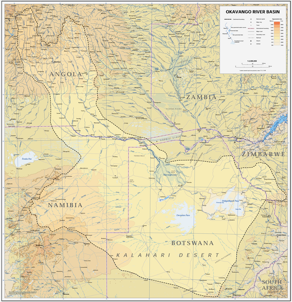
Afrikaans: Kaart van die opvangsgebied en waterskeiding (stippellyn) van die Kavangorivier in Angola, Namibië en Botswana
English: Map of the Okavango River Basin, with catchment area inside the dotted line (Angola, Namibia, Botswana) |
| Data | |
| Origem | https://digitallibrary.un.org/record/423191?ln=en |
| Autor | United Nations |
| Permissão (Reutilizar este ficheiro) |
UN map as PD |
| Outras versões |
 |
| This image is a map derived from a United Nations map.
Unless stated otherwise, UN maps are to be considered in the public domain. This applies worldwide. UN maps are, in principle, open source material and you can use them in your work or for making your own map. UN requests however that you delete the UN name, logo and reference number upon any modification to the map. Content of your map will be your responsibility. You can state in your publication, if you wish, something like: based on UN map … (map name, map number, revision number and date). See: Geospatial Information Section. And: Geospatial, location data for a better world. |
 |
Histórico do ficheiro
Clique uma data e hora para ver o ficheiro tal como ele se encontrava nessa altura.
| Data e hora | Miniatura | Dimensões | Utilizador | Comentário | |
|---|---|---|---|---|---|
| atual | 14h22min de 6 de janeiro de 2019 | | 3 052 × 3 160 (8,63 MB) | JMK | adjust midtones |
| 17h09min de 16 de abril de 2008 |  | 3 052 × 3 160 (8,15 MB) | Foundert~commonswiki | {{Information |Description=map of the Okavango River Basin (Angola, Namibia, Botswana) |Source=http://www.un.org/Depts/Cartographic/english/htmain.htm |Date=16. April 2008 |Author=United Nations |Permission=UN map as PD |other_versions= }} {{UN map}} [[ |
Utilização local do ficheiro
As seguintes 2 páginas usam este ficheiro:
Utilização global do ficheiro
As seguintes wikis usam este ficheiro:
- af.wikipedia.org
- ar.wikipedia.org
- ast.wikipedia.org
- avk.wikipedia.org
- azb.wikipedia.org
- bg.wikipedia.org
- ca.wikipedia.org
- cs.wikipedia.org
- da.wikipedia.org
- de.wikipedia.org
- el.wikipedia.org
- en.wikipedia.org
- es.wikipedia.org
- fi.wikipedia.org
- frr.wikipedia.org
- fr.wikipedia.org
- gl.wikipedia.org
- he.wikipedia.org
- hr.wikipedia.org
- hu.wikipedia.org
- id.wikipedia.org
- it.wikipedia.org
- ja.wikipedia.org
- ka.wikipedia.org
- ko.wikipedia.org
- lv.wikipedia.org
- mk.wikipedia.org
- ml.wikipedia.org
- nl.wikipedia.org
- oc.wikipedia.org
- pl.wikipedia.org
- ro.wikipedia.org
- sh.wikipedia.org
- sk.wikipedia.org
- sr.wikipedia.org
- sw.wikipedia.org
- ta.wikipedia.org
- th.wikipedia.org
- uk.wikipedia.org
Ver mais utilizações globais deste ficheiro.