
Ficheiro:Reichskanzlei-Vorbunker.png

Imagem numa resolução maior (1 607 × 3 514 píxeis, tamanho: 356 kB, tipo MIME: image/png)
|
|
Esta imagem provém do Wikimedia Commons, um acervo de conteúdo livre da Wikimedia Foundation que pode ser utilizado por outros projetos.
|
| Descrição |
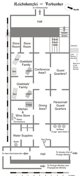
Map of the Vorbunker in Berlin, 1945. |
| Data | |
| Origem | Obra do próprio |
| Autor | User:Dna-Dennis |
| Permissão (Reutilizar este ficheiro) |
CC, see below. The map is completely unrestricted for any Wikipedia/Wikimedia project. |
Licenciamento
- Pode:
- partilhar – copiar, distribuir e transmitir a obra
- recombinar – criar obras derivadas
- De acordo com as seguintes condições:
- atribuição – Tem de fazer a devida atribuição da autoria, fornecer uma hiperligação para a licença e indicar se foram feitas alterações. Pode fazê-lo de qualquer forma razoável, mas não de forma a sugerir que o licenciador o apoia ou subscreve o seu uso da obra.
Descrição do ficheiro
This is a map of the Vorbunker in Berlin, 1945 - the "antechamber" bunker of the famous Fuehrerbunker. The layout is not necessarily perfectly exact, but it is very probable. There were two bunkers which were connected - the Fuehrerbunker and the Vorbunker, and here is the link to my map of the Fuehrerbunker, and a link to my map showing the locations of the Fuehrerbunker and Vorbunker in Berlin, 1945.
Information about the details of the bunkers is rather scarce, which is not strange, since the bunkers were secret. This map is based on the excellent research of Tom Posch (see below), who visited and photographed the remains from inside in 1988. He concluded that the map of the bunker in Cornelius Ryan's The Last Battle was incorrect, and a new, hand-drawn map of the Vorbunker was produced by Tom Posch.
Location notes
The Fuehrerbunker, built in 1944, was located 8-17 meters beneath the Reichskanzlei garden, approx. 120 meters north of the new Reichskanzlei building, which had the address Vossstrasse 6. The Führerbunker was located somewhat lower than the Vorbunker and west (or rather west-west-south) of it. The two bunkers were connected via sets of stairs set at right angles (not spiral).
Layout notes
- Particularly uncertain items are marked with question marks.
- The exact position of water & ventilation facilites and showers are uncertain.
Construction data (approximates)
- Material: Concrete
- Protective Wall Width: 220 cm
- Protective Roof Height: 280 cm
- Wall Width (interior): 15-20 cm
- Door Heights: 180-200 cm
- Door Widths: 120 cm
- Room Heights: 2-3 m
- Room Sizes: Varying; 3-5 m
References
The map is based on the following sources:
- Ramsey, Winston G. (editor) & Posch, Tom (researcher), The Berlin Führerbunker: The Thirteenth Hole, After the Battle cópia arquivada at the Wayback Machine, No.61, Special Edition, Battle of Britain International Ltd, 1988, London
- Allied Intelligence Map of Key Buildings in Berlin (3rd edition, 1945)
- Ryan, Cornelius, The Last Battle (1966)
Regards,
Dennis Nilsson, Sweden.
If you wish to contact me, please leave a message on my talk page.

|
Esta imagem de architecture (ou todas as imagens neste artigo ou categoria) deveriam ser recriadas usando gráficos vectoriais, como ficheiros SVG. Isto tem várias vantagens; veja as Commons:Media for cleanup|imagens para rever para mais informações. Se já criou um ficheiro SVG desta imagem, por favor, carregue-o. Depois do novo ficheiro SVG ter sido carregado, substitua aqui esta predefinição pela predefinição {{vector version available|nome da nova imagem.svg}}.
|
Histórico do ficheiro
Clique uma data e hora para ver o ficheiro tal como ele se encontrava nessa altura.
| Data e hora | Miniatura | Dimensões | Utilizador | Comentário | |
|---|---|---|---|---|---|
| atual | 13h49min de 9 de fevereiro de 2007 | | 1 607 × 3 514 (356 kB) | Dcoetzee | Remove license info and detailed description; these belong in the image description page or article; pngcrushed |
| 23h02min de 29 de janeiro de 2006 |  | 2 356 × 3 441 (757 kB) | Dna-webmaster~commonswiki | ||
| 22h27min de 29 de janeiro de 2006 |  | 2 357 × 3 441 (696 kB) | Dna-webmaster~commonswiki | == Licensing == {{self|cc-by-sa-2.5}} I hereby release this image with the following declaration: <i>Reproduction and distribution is allowed and encouraged as long as the author is acknowledged by name when this image is used.</i> == Description == T |
Utilização local do ficheiro
As seguintes 2 páginas usam este ficheiro:
Utilização global do ficheiro
As seguintes wikis usam este ficheiro:
- ar.wikipedia.org
- br.wikipedia.org
- da.wikipedia.org
- el.wikipedia.org
- en.wikipedia.org
- es.wikipedia.org
- he.wikipedia.org
- id.wikipedia.org
- it.wikipedia.org
- ja.wikipedia.org
- ms.wikipedia.org
- nl.wikipedia.org
- no.wikipedia.org
- ru.wikipedia.org
- sv.wikipedia.org
- tr.wikipedia.org
- www.wikidata.org