
Ficheiro:Schlieffen Plan.jpg

Imagem numa resolução maior (963 × 745 píxeis, tamanho: 732 kB, tipo MIME: image/jpeg)
|
|
Esta imagem provém do Wikimedia Commons, um acervo de conteúdo livre da Wikimedia Foundation que pode ser utilizado por outros projetos.
|

|
File:Schlieffen Plan fr.svg é uma versão vetorial deste ficheiro. Ela deve ser usada em vez desta imagem em formato raster, se não for de qualidade inferior.
File:Schlieffen Plan.jpg → File:Schlieffen Plan fr.svg
Para mais informações, consulte Ajuda:SVG. |
 |
| Descrição |
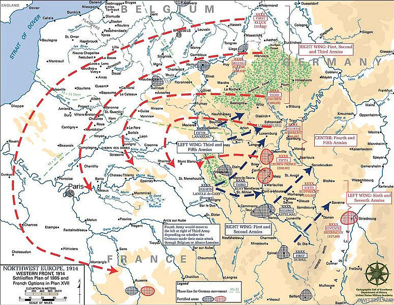
English: Schlieffen Plan
In 1938 the predecessors of what is today The Department of History at the United States Military Academy began developing a series of campaign atlases to aid in teaching cadets a course entitled, "History of the Military Art." Since then, the Department has produced over six atlases and more than one thousand maps, encompassing not only America’s wars but global conflicts as well. In keeping abreast with today's technology, the Department of History is providing these maps on the internet as part of the department's outreach program. The maps were created by the United States Military Academy’s Department of History and are the digital versions from the atlases printed by the United States Defense Printing Agency. We gratefully acknowledge the accomplishments of the department's former cartographer, Mr. Edward J. Krasnoborski, along with the works of our present cartographer, Mr. Frank Martini. Please be aware that these maps are large in file size and may require substantial download times. |
| Data | 05/09/2008 |
| Origem | Westpoint.edu, WWI Atlas, Shlieffen Plan |
| Autor | Tinodela |
| Outras versões |
|
Esta imagem é um trabalho de um soldado ou funcionário do Exército dos Estados Unidos, tirada ou feita durante o curso de uma tarefa oficial. Como trabalho do Governo Federal dos Estados Unidos, a imagem está em domínio público.
|
 |
Derivative works
Obras derivadas deste ficheiro: Schlieffen Plan.svg
Histórico do ficheiro
Clique uma data e hora para ver o ficheiro tal como ele se encontrava nessa altura.
| Data e hora | Miniatura | Dimensões | Utilizador | Comentário | |
|---|---|---|---|---|---|
| atual | 11h43min de 23 de julho de 2012 | | 963 × 745 (732 kB) | Soerfm | Paris |
| 11h58min de 1 de março de 2006 |  | 969 × 751 (273 kB) | W.wolny |
Utilização local do ficheiro
As seguintes 2 páginas usam este ficheiro:
Utilização global do ficheiro
As seguintes wikis usam este ficheiro:
- ar.wikipedia.org
- be-tarask.wikipedia.org
- be.wikipedia.org
- bg.wikipedia.org
- ca.wikipedia.org
- cs.wikipedia.org
- da.wikipedia.org
- de.wikipedia.org
- de.wikibooks.org
- de.wikinews.org
- el.wikipedia.org
- en.wikipedia.org
- en.wikibooks.org
- fi.wikipedia.org
- fr.wikipedia.org
Ver mais utilizações globais deste ficheiro.