
Ficheiro:2018 George Washington Brdge Bus Station from West 178th Street and Broadway looking west.jpg

Dimensões desta antevisão: 788 × 600 píxeis. Outras resoluções: 315 × 240 píxeis | 631 × 480 píxeis | 1 009 × 768 píxeis | 1 280 × 974 píxeis | 2 560 × 1 949 píxeis | 3 953 × 3 009 píxeis.
Imagem numa resolução maior (3 953 × 3 009 píxeis, tamanho: 2,18 MB, tipo MIME: image/jpeg)
|
|
Esta imagem provém do Wikimedia Commons, um acervo de conteúdo livre da Wikimedia Foundation que pode ser utilizado por outros projetos.
|
Descrição do ficheiro
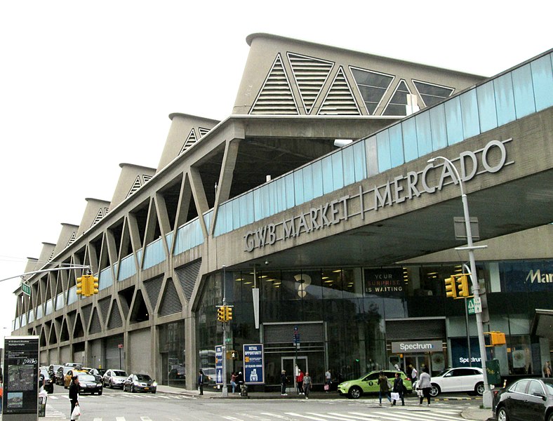
| Descrição | The George Washington Bridge Bus Station, located between Fort Washington and Wadsworth Avenues and 178th and 179th Streets in the Washington Heights neighborhood of Manhattan, New York City, straddles the Trans-Manhattan Expressway (Interstate 95). It was built in 1963 and was designed by the Port Authority of New York and New Jersey and Pier Luigi Nervi. (Source: AIA Guide to NYC (5th ed.) This image was taken from the southeast corner of Broadway and 178th Street. |
| Data | |
| Origem | Obra do próprio |
| Autor | Beyond My Ken |
| Localização da câmara | | Esta e outras imagens nas suas localizações em: OpenStreetMap |
|---|
Licenciamento
Eu, titular dos direitos de autor desta obra, publico-a com as seguintes licenças:

|
É concedida permissão para copiar, distribuir e/ou modificar este documento nos termos da Licença de Documentação Livre GNU, versão 1.2 ou qualquer versão posterior publicada pela Free Software Foundation; sem Secções Invariantes, sem textos de Capa e sem textos de Contra-Capa. É incluída uma cópia da licença na secção intitulada GNU Free Documentation License. |
This file is licensed under the Creative Commons Attribution-Share Alike 4.0 International, 3.0 Unported, 2.5 Generic, 2.0 Generic and 1.0 Generic license.
- Pode:
- partilhar – copiar, distribuir e transmitir a obra
- recombinar – criar obras derivadas
- De acordo com as seguintes condições:
- atribuição – Tem de fazer a devida atribuição da autoria, fornecer uma hiperligação para a licença e indicar se foram feitas alterações. Pode fazê-lo de qualquer forma razoável, mas não de forma a sugerir que o licenciador o apoia ou subscreve o seu uso da obra.
- partilha nos termos da mesma licença – Se remisturar, transformar ou ampliar o conteúdo, tem de distribuir as suas contribuições com a mesma licença ou uma licença compatível com a original.
Pode escolher a licença que quiser.
Histórico do ficheiro
Clique uma data e hora para ver o ficheiro tal como ele se encontrava nessa altura.
| Data e hora | Miniatura | Dimensões | Utilizador | Comentário | |
|---|---|---|---|---|---|
| atual | 00h28min de 24 de junho de 2018 | | 3 953 × 3 009 (2,18 MB) | Beyond My Ken | == {{int:filedesc}} == {{Information |Description= The George Washington Bridge Bus Station, located between Fort Washington and Wadsworth Avenues and 178th and 179th Streets in the Washington Heights neighborhood of Manhattan, New York City, straddles the Trans-Manhattan Expressway (Interstate 95). It was built in 1963 and was designed by the Port Authority of New York and New Jersey and Pier Luigi Nervi. (Source: ''AIA Guide to NYC'' (5th ed.) This image was taken from the southeast corne... |
Utilização local do ficheiro
A seguinte página usa este ficheiro:
Utilização global do ficheiro
As seguintes wikis usam este ficheiro:
- en.wikipedia.org
- fr.wikipedia.org