
Ficheiro:Anatolia1300.png
Sem resolução maior disponível.
Anatolia1300.png (535 × 330 píxeis, tamanho: 81 kB, tipo MIME: image/png)
|
|
Esta imagem provém do Wikimedia Commons, um acervo de conteúdo livre da Wikimedia Foundation que pode ser utilizado por outros projetos.
|
Descrição do ficheiro
| Descrição |
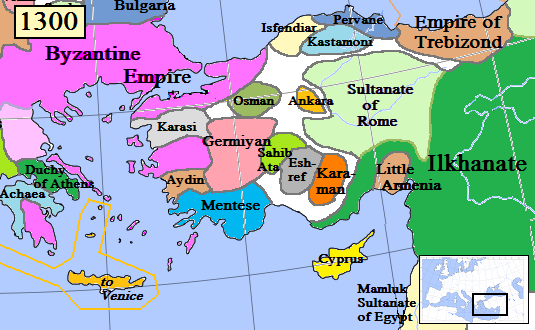
English: Map of the Anatolia region in AD 1300.
(Partially based on Euratlas map of Europe, 1300.) |
| Data | |
| Origem | Obra do próprio |
| Autor | Gabagool |
| Outras versões |
.png)
Licenciamento
Eu, titular dos direitos de autor desta obra, publico-a com a seguinte licença:
A utilização deste ficheiro é regulada nos termos da licença Creative Commons - Atribuição 3.0 Não Adaptada.
- Pode:
- partilhar – copiar, distribuir e transmitir a obra
- recombinar – criar obras derivadas
- De acordo com as seguintes condições:
- atribuição – Tem de fazer a devida atribuição da autoria, fornecer uma hiperligação para a licença e indicar se foram feitas alterações. Pode fazê-lo de qualquer forma razoável, mas não de forma a sugerir que o licenciador o apoia ou subscreve o seu uso da obra.
Histórico do ficheiro
Clique uma data e hora para ver o ficheiro tal como ele se encontrava nessa altura.
| Data e hora | Miniatura | Dimensões | Utilizador | Comentário | |
|---|---|---|---|---|---|
| atual | 16h46min de 20 de janeiro de 2017 | | 535 × 330 (81 kB) | Cplakidas | fixing Dodecanese: Menteshe never controlled the offshore islands; they remained Byzantine until the Hospitallers or Genoese of Chios took them. |
| 22h26min de 17 de abril de 2009 |  | 535 × 330 (64 kB) | Gabagool | Byzantine color lighter. New Armenia -> Little Armenia | |
| 19h12min de 2 de abril de 2009 |  | 535 × 330 (64 kB) | Gabagool | added mamluks | |
| 16h36min de 31 de março de 2009 |  | 535 × 330 (63 kB) | Gabagool | {{Information |Description={{en|1=Map of the Anatolia region in AD 1300. (Partially based on Euratlas map of Europe, 1300.)}} |Source=Own work by uploader |Author=Gabagool |Date=2009-03-31 |Permission= |other_versions= }} <!--{{ImageUp |
Utilização local do ficheiro
Não há nenhuma página que use este ficheiro.
Utilização global do ficheiro
As seguintes wikis usam este ficheiro:
- als.wikipedia.org
- ar.wikipedia.org
- arz.wikipedia.org
- azb.wikipedia.org
- ba.wikipedia.org
- bg.wikipedia.org
- bn.wikipedia.org
- ca.wikipedia.org
- cs.wikipedia.org
- de.wikipedia.org
- el.wikipedia.org
- en.wikipedia.org
Ver mais utilizações globais deste ficheiro.