
Ficheiro:Beginning Point of the U.S. Public Land Survey front.jpg

Dimensões desta antevisão: 450 × 600 píxeis. Outras resoluções: 180 × 240 píxeis | 360 × 480 píxeis | 576 × 768 píxeis | 768 × 1 024 píxeis | 2 112 × 2 816 píxeis.
Imagem numa resolução maior (2 112 × 2 816 píxeis, tamanho: 3,37 MB, tipo MIME: image/jpeg)
|
|
Esta imagem provém do Wikimedia Commons, um acervo de conteúdo livre da Wikimedia Foundation que pode ser utilizado por outros projetos.
|
|
Esta é uma imagem de um sítio ou edifício atualmente classificado no Registo Nacional de Lugares Históricos dos Estados Unidos da América. O seu número de referência é 66000606. |
| Localização da câmara | | Esta e outras imagens nas suas localizações em: OpenStreetMap |
|---|
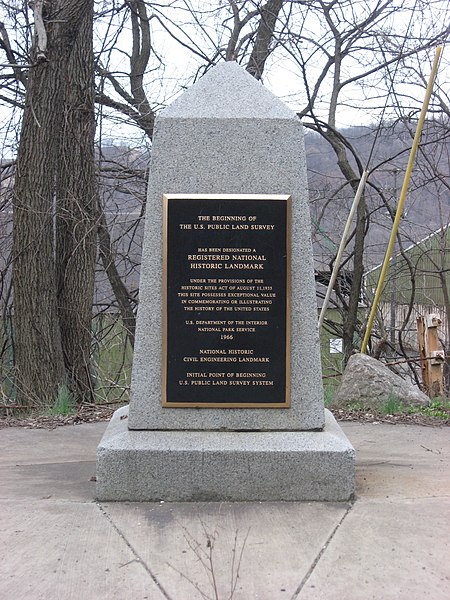
| Descrição | Streetside view of the Beginning Point of the U.S. Public Land Survey, a monument marking the site that served as the basis for the entire Public Land Survey System — the system by which most of the United States, outside of the original colonies, was surveyed. Located on the Ohio/Pennsylvania border east of downtown East Liverpool, Ohio, it is split between the city of East Liverpool and the borough of Ohioville in Beaver County, Pennsylvania. Erected in 1881 by a joint commission of Ohio and Pennsylvania surveyors, the monument was declared a National Historic Landmark in 1966. The road on which it lies is Ohio State Route 39 and Pennsylvania Route 68. | ||
| Data | Tirada em 28 de março de 2009 | ||
| Origem | Obra do próprio | ||
| Autor | User:Nyttend | ||
| Permissão (Reutilizar este ficheiro) |
|
||
| Outras versões |
 Ohio and Ohio and  Pennsylvania sides of the monument Pennsylvania sides of the monument |
Histórico do ficheiro
Clique uma data e hora para ver o ficheiro tal como ele se encontrava nessa altura.
| Data e hora | Miniatura | Dimensões | Utilizador | Comentário | |
|---|---|---|---|---|---|
| atual | 04h29min de 28 de março de 2009 | | 2 112 × 2 816 (3,37 MB) | Nyttend | {{Location|40|38|33|N|80|31|10|W}} {{Information |Description=Streetside view of the {{w|Beginning Point of the U.S. Public Land Survey}}, a monument marking the site that served as the basis for the entire {{w|Public Land Survey System}} — the system b |
Utilização local do ficheiro
A seguinte página usa este ficheiro:
Utilização global do ficheiro
As seguintes wikis usam este ficheiro:
- ca.wikipedia.org
- de.wikipedia.org
- en.wikipedia.org
- Public Land Survey System
- List of Historic Civil Engineering Landmarks
- Point of beginning
- List of National Historic Landmarks in Pennsylvania
- List of National Historic Landmarks in Ohio
- Beginning Point of the U.S. Public Land Survey
- National Register of Historic Places listings in Columbiana County, Ohio
- National Register of Historic Places listings in Beaver County, Pennsylvania
- List of Pennsylvania state historical markers in Beaver County
- User talk:Dthomsen8/List PA Test
- en.wikivoyage.org
- es.wikipedia.org
- fr.wikipedia.org
- hu.wikipedia.org
- it.wikipedia.org
- ja.wikipedia.org
- tl.wikipedia.org
- ur.wikipedia.org
- vi.wikipedia.org
- www.wikidata.org