
Ficheiro:Benghazi Conflict Detailed Map.svg

Dimensões desta antevisão em PNG do ficheiro SVG: 712 × 600 píxeis Outras resoluções: 285 × 240 píxeis | 570 × 480 píxeis | 912 × 768 píxeis | 1 215 × 1 024 píxeis | 2 431 × 2 048 píxeis | 978 × 824 píxeis.
Imagem numa resolução maior (ficheiro SVG, de 978 × 824 píxeis, tamanho: 3,24 MB)
|
|
Esta imagem provém do Wikimedia Commons, um acervo de conteúdo livre da Wikimedia Foundation que pode ser utilizado por outros projetos.
|
Descrição do ficheiro
| Descrição |
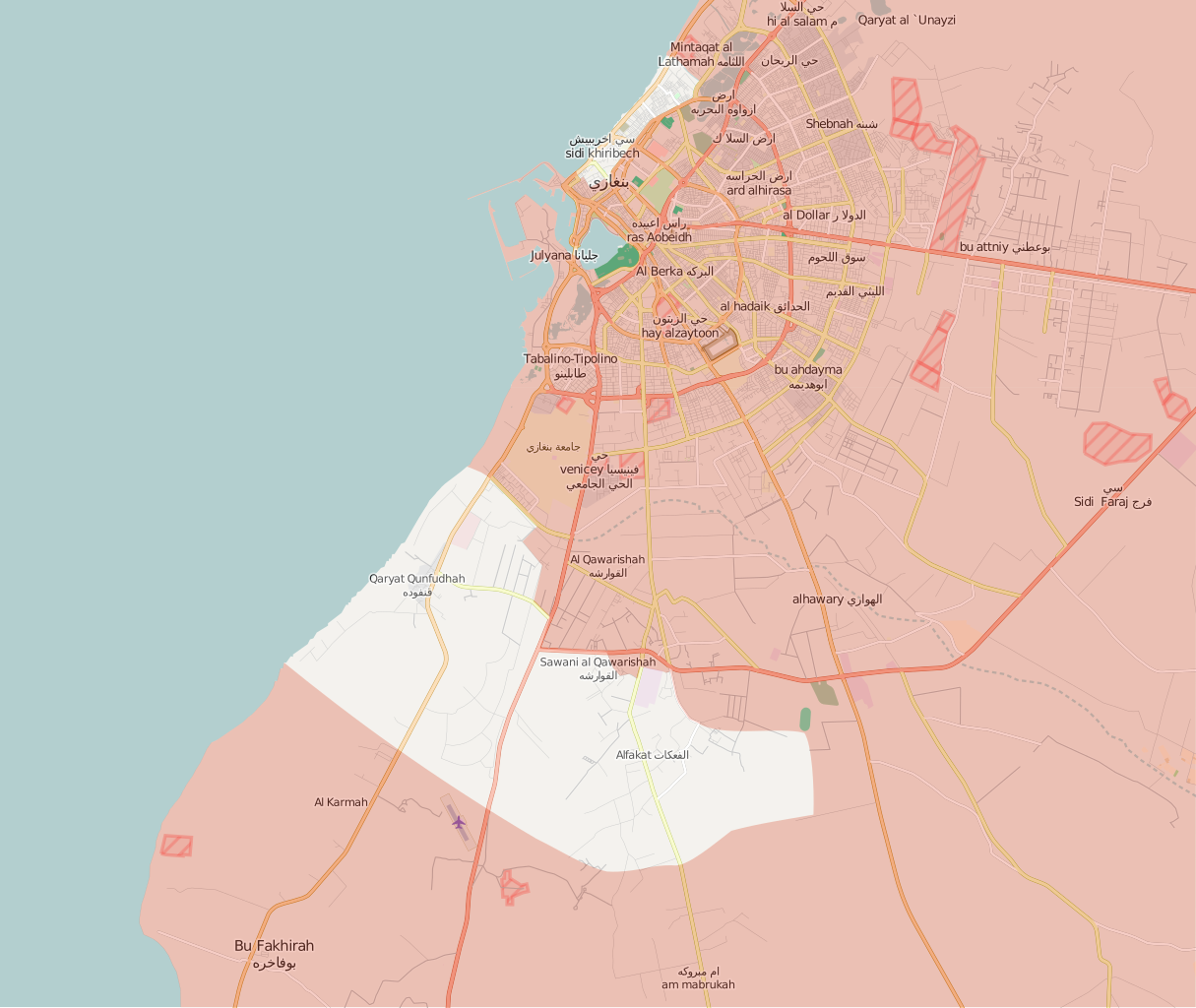
Deutsch:
Unter Kontrolle des Abgeordnetenrats in Tobruk und Verbündeten
Kontrolliert durch Revolutionärer Schura-Rat von Bengasi English:
Under the control of the Tobruk-led Government and Libyan National Army
Controlled by the Shura Council of Benghazi Revolutionaries Italiano:
Sotto il controllo del Governo di Tobruk e Alleati
Controllato dallo Consiglio consultivo dei rivoluzionari di Bengasi |
||||
| Data | |||||
| Origem | Obra do próprio, after the map from PutItOnAMap, basic map from http://www.openstreetmap.org. | ||||
| Autor | Ermanarich | ||||
| Outras versões |
|


.svg)

.png)


.svg)


.svg)


_Territory_Change_2014-2016.gif)

_(within_Northern_Syria).svg)


.png)
.svg)


_map.png)
.svg)


.svg)


Licenciamento
Eu, titular dos direitos de autor desta obra, publico-a com a seguinte licença:
A utilização deste ficheiro é regulada nos termos da licença Creative Commons Atribuição-CompartilhaIgual 4.0 Internacional.
- Pode:
- partilhar – copiar, distribuir e transmitir a obra
- recombinar – criar obras derivadas
- De acordo com as seguintes condições:
- atribuição – Tem de fazer a devida atribuição da autoria, fornecer uma hiperligação para a licença e indicar se foram feitas alterações. Pode fazê-lo de qualquer forma razoável, mas não de forma a sugerir que o licenciador o apoia ou subscreve o seu uso da obra.
- partilha nos termos da mesma licença – Se remisturar, transformar ou ampliar o conteúdo, tem de distribuir as suas contribuições com a mesma licença ou uma licença compatível com a original.
Histórico do ficheiro
Clique uma data e hora para ver o ficheiro tal como ele se encontrava nessa altura.
| Data e hora | Miniatura | Dimensões | Utilizador | Comentário | |
|---|---|---|---|---|---|
| atual | 17h14min de 4 de janeiro de 2018 | | 978 × 824 (3,24 MB) | MonsterHunter32 | Reverted to version as of 23:43, 22 August 2016 (UTC) so that the readers can see the situation when the battle was occuring. |
| 15h00min de 10 de novembro de 2017 |  | 1 044 × 879 (3,21 MB) | Kami888 | Revert - turns out Sidi Akribesh was never captured after all | |
| 12h15min de 10 de julho de 2017 |  | 1 044 × 879 (3,21 MB) | Kami888 | LNA claims last militants are defeated, the battle is over. https://www.libyaherald.com/2017/07/09/breaking-lna-says-tonight-it-has-taken-last-benghazi-militant-positions/ | |
| 04h06min de 7 de julho de 2017 |  | 1 044 × 879 (3,21 MB) | Kami888 | Hospital, hotel, and most of the Sabri district is claimed by LNA. Last militants are holding out in Sidi Akribesh. https://www.libyaherald.com/2017/07/05/breaking-lna-says-benghazis-sabri-has-all-but-fallen/ https://www.libyaherald.com/2017/07/06/lead... | |
| 03h01min de 25 de junho de 2017 |  | 1 044 × 879 (3,21 MB) | Kami888 | suddenly... souq al hout and eastern sabri reportedly taken as militants flee. Clashes at Sharif Street in the west and at wahda (sabri branch) bank in the east. https://www.libyaherald.com/2017/06/23/benghazis-suq-al-hout-finally-taken-says-lna-heavin... | |
| 00h20min de 22 de junho de 2017 |  | 1 044 × 879 (3,21 MB) | Kami888 | Fish market (Souk al Hout), Erkheis mosque, and much of the Al-Ageeb street is captured. Using a relatively conservative estimate since the capture of the Christian churches has not been reported. https://www.libyaherald.com/2017/06/19/lna-says-it-has-... | |
| 06h40min de 19 de junho de 2017 |  | 1 044 × 879 (3,21 MB) | Kami888 | wahda bank & misrata street in souq-al-hout to red https://www.libyaherald.com/2017/06/16/five-lna-soldiers-killed-in-suq-al-hout-offensive/ | |
| 01h21min de 15 de junho de 2017 |  | 1 044 × 879 (3,21 MB) | Kami888 | Tahrir square and courthouse captured https://www.libyaherald.com/2017/06/13/benghazis-iconic-tahrir-square-taken-by-lna-as-suq-al-hout-hit-by-airstrikes/ | |
| 08h51min de 13 de junho de 2017 |  | 1 044 × 879 (3,21 MB) | Kami888 | Adjusted frontlines based on multiple sources linked in talk page. Also added an unclear area where I just can't figure out what is happening. In line with the similar maps that area is marked in #8080007b. This change does not represent SCBR advance. | |
| 01h25min de 23 de março de 2017 |  | 1 044 × 879 (3,24 MB) | Kami888 | https://www.libyaherald.com/2017/03/18/breaking-ganfouda-12-apartments-complex-finally-taken/ |
Utilização local do ficheiro
A seguinte página usa este ficheiro:
Utilização global do ficheiro
As seguintes wikis usam este ficheiro:
- ar.wikipedia.org
- be.wikipedia.org
- en.wikipedia.org
- es.wikipedia.org
- fa.wikipedia.org
- fr.wikipedia.org
- ru.wikipedia.org
- www.wikidata.org