
Ficheiro:CornwallKernowMappa.png
Dimensões desta antevisão: 800 × 587 píxeis. Outras resoluções: 320 × 235 píxeis | 640 × 469 píxeis | 952 × 698 píxeis.
Imagem numa resolução maior (952 × 698 píxeis, tamanho: 167 kB, tipo MIME: image/png)
|
|
Esta imagem provém do Wikimedia Commons, um acervo de conteúdo livre da Wikimedia Foundation que pode ser utilizado por outros projetos.
|
Descrição do ficheiro
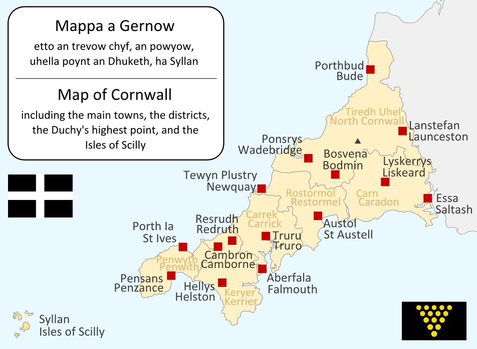
I made this map myself in September 2004. It is bilingual in Cornish and English, and shows the modern-day administrative boundaries of Cornwall and the larger towns. QuartierLatin1968 17:36, 14 Apr 2005 (UTC)

|
É concedida permissão para copiar, distribuir e/ou modificar este documento nos termos da Licença de Documentação Livre GNU, versão 1.2 ou qualquer versão posterior publicada pela Free Software Foundation; sem Secções Invariantes, sem textos de Capa e sem textos de Contra-Capa. É incluída uma cópia da licença na secção intitulada GNU Free Documentation License. |
| A utilização deste ficheiro é regulada nos termos da licença Creative Commons - Atribuição-CompartilhaIgual 3.0 Não Adaptada. | ||
| ||
| Esta marca de licenciamento foi adicionada a este ficheiro durante a atualização da licença GFDL. |
| Anotações | Esta imagem está anotada: Ver as anotações na wiki Commons |
Histórico do ficheiro
Clique uma data e hora para ver o ficheiro tal como ele se encontrava nessa altura.
| Data e hora | Miniatura | Dimensões | Utilizador | Comentário | |
|---|---|---|---|---|---|
| atual | 19h09min de 23 de junho de 2011 | | 952 × 698 (167 kB) | Lader Gwiader | improve, SWF, place names from "A Concise Dictionary of Cornish Place Names" |
| 04h38min de 21 de agosto de 2005 |  | 643 × 469 (30 kB) | QuartierLatin1968 | one or two grammatical fixes, less jarring colours | |
| 17h33min de 14 de abril de 2005 |  | 644 × 474 (21 kB) | QuartierLatin1968 | I made this map myself in September 2004. It is bilingual in Cornish and English, and shows the modern-day administrative boundaries of Cornwall and the larger towns. {{GFDL}} |
Utilização local do ficheiro
Não há nenhuma página que use este ficheiro.
Utilização global do ficheiro
As seguintes wikis usam este ficheiro:
- af.wikipedia.org
- an.wikipedia.org
- ast.wikipedia.org
- br.wikipedia.org
- ca.wikipedia.org
- cs.wikipedia.org
- cy.wikipedia.org
- el.wiktionary.org
- en.wikipedia.org
- eo.wikipedia.org
- es.wikipedia.org
- frr.wikipedia.org
- fr.wikipedia.org
- fy.wikipedia.org
- gd.wikipedia.org
- he.wikipedia.org
- קורנית (שפה)
- תבנית:הידעת? 10 ביולי - סדרה 2
- פורטל:הממלכה המאוחדת/הידעת?/קטעי הידעת?
- פורטל:בלשנות/הידעת?/קטעי הידעת
- פורטל:בלשנות/הידעת?/10
- פורטל:הממלכה המאוחדת/הידעת?/17
- תבנית:הידעת? 10 ביולי 2013
- ויקיפדיה:הידעת?/2013/יולי
- ויקיפדיה:הידעת?/2016/יולי
- תבנית:הידעת? 12 ביולי 2016
- ויקיפדיה:הידעת?/2018/יולי
- תבנית:הידעת? 19 ביולי 2018
- ויקיפדיה:הידעת?/2019/יולי
- תבנית:הידעת? 10 ביולי 2019
Ver mais utilizações globais deste ficheiro.