Ficheiro:Late Medieval Trade Routes.jpg
O conteúdo da página não é suportado noutras línguas.
Origem: Wikipédia, a enciclopédia livre.

Imagem numa resolução maior(1 457 × 1 088 píxeis, tamanho: 372 kB, tipo MIME: image/jpeg)

Descrição do ficheiro

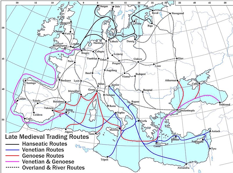
Descrição Map showing the main trade routes of late medieval Europe. The black lines show the routes of the Hanseatic League, the blue Venetian and the red Genoese routes. Purple lines are routes used by both the Venetians and the Genoese. Overland and river routes are stippled.
Data
Origem Obra do próprio
Autor Lampman
Outras versões The map is based on this: , which in turn is based on an old, PD map. Magyar svg

Licenciamento

Public domain Eu, titular dos direitos de autor desta obra, dedico-a ao domínio público, com aplicação em todo o mundo.
Nalguns países isto pode não ser legalmente possível; se assim for:
Concedo a todos o direito de usar esta obra para qualquer fim, sem quaisquer condições, a menos que tais condições sejam impostas por lei.
Kaarten van de geschiedenis van Europa
BCE
aC

Weichselian ice age (c. 113,000–9700) · Neolithic expansion (c. 7000–4500) · Middle Neolithic (c. 4500–4000) · Late Neolithic (c. 4000–3000) · Copper Age – Corded Ware culture (c. 2900–2350) · Copper Age – Bellbeaker culture (c. 2800–1800) · Early Bronze Age – Unetice culture (c. 2300–1600) · Late Bronze Age – Urnfield culture (c. 1300—750) · Migrations (c. 1000–100) · Hallstatt & La Tène cultures (c. 800–100) · Roman Republic (510–40) · 220 · 218 · 200 · 201–100 · 58 · 49 · 39 · 30 BCE–6 CE


CE
dC

14 · 14–37 · 60 · 60 · 69 · 80 · Migrations 100–500 · 117 · 117 · 125 · Migrations 150–774 · Economy 180 · 271 · 293–305 · 337 · 395 · c. 395 · 400 · 400 · 450 · 457–61 · 476 · 480 · Franks 481–814 · Early Slavs 500–700 · 500 · 526 · 526–600 · Christianisation to 600 · c. 550 · 650 · Pontic Steppe 650 · 665 · 800 · Vikings 800–1050 · 814 · 843–70 · 850 · 900 · 912 · 998 · 1000 · 1000 · 1054 · 1092 · First Crusade 1095–99 · 1097 · 1135 · 1142 · 1147–49 · 1190 · 1190 · 1250 · c. 1250 · 1301-1400 · 1301-1400 · 1328 · 1345 · Black Plague 1347–51 · 1360 · 1400 · Trade routes c. 1400 · 1430 · 1470 · 1490 · 1492 · 1500 · 1519 · 1550 · 1560 · Religion 1560 · Religion 1600 · Religion 1618 · 1618–48 · 1648 · 1683 · 1700 · 1701 · 1708 · 1714 · 1721 · 1725–30 · 1739–1740 · 1740 · 1748–66 · 1783–1792 · 1787 · 1787 · 1789 · 1799 · 1812 · 1812 · 1812 · 1812 · 1813 · 1815 · 1815 · 1815 · 1818 · Ottoman Empire 1830–1923 · 1848–49 · 1861 · 1867 · 1871 · 1878 · 1890 · 1905 · 1911 · 1914 · 1914 · 1919 · 1919–29 · 1923 · 1929 · 1930 · 1940 · 1941–42 · 1942–45 · Cold War 1947–91 · 1950 · 1993–2006 · 2006 to date

(this template: · view · discuss )

Legendas

Adicione uma explicação de uma linha do que este ficheiro representa

Elementos retratados neste ficheiro

retrata

image/jpeg

Histórico do ficheiro

Clique uma data e hora para ver o ficheiro tal como ele se encontrava nessa altura.

Data e horaMiniaturaDimensõesUtilizadorComentário
atual20h46min de 18 de maio de 2022Miniatura da versão das 20h46min de 18 de maio de 20221 457 × 1 088 (372 kB)Richard2sClearer key for map
20h25min de 23 de janeiro de 2011Miniatura da versão das 20h25min de 23 de janeiro de 2011853 × 544 (453 kB)Micsha~commonswikiIncludes map key on the map
15h55min de 28 de março de 2008Miniatura da versão das 15h55min de 28 de março de 20081 817 × 1 120 (487 kB)Lampman{{Information |Description=Map showing the main trade routes of late medieval Europe. The black lines show the routes of the Hanseatic League, the blue Venetian and the red Genoese routes. Purple lines are routes used by both the Venetians and the Genoese

A seguinte página usa este ficheiro:

Utilização global do ficheiro

As seguintes wikis usam este ficheiro:

Ver mais utilizações globais deste ficheiro.