
Ficheiro:Map of Kentucky highlighting Lincoln County.svg

Dimensões desta antevisão em PNG do ficheiro SVG: 800 × 345 píxeis Outras resoluções: 320 × 138 píxeis | 640 × 276 píxeis | 1 024 × 441 píxeis | 1 280 × 551 píxeis | 2 560 × 1 103 píxeis | 6 770 × 2 916 píxeis.
Imagem numa resolução maior (ficheiro SVG, de 6 770 × 2 916 píxeis, tamanho: 127 kB)
|
|
Esta imagem provém do Wikimedia Commons, um acervo de conteúdo livre da Wikimedia Foundation que pode ser utilizado por outros projetos.
|
Descrição do ficheiro
| Descrição |
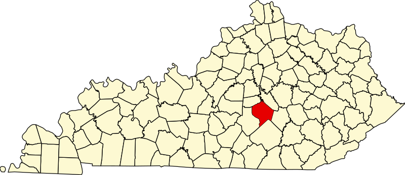
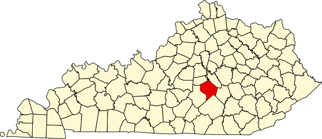
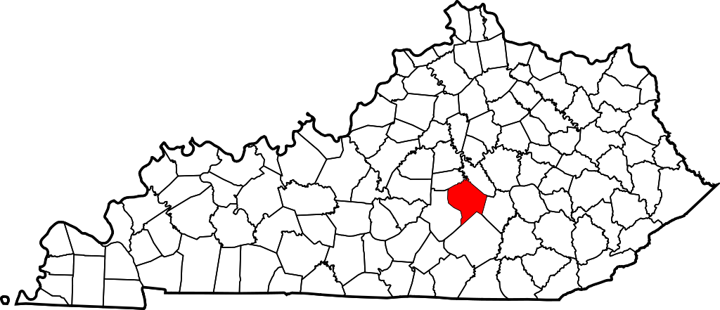
English: This is a locator map showing Lincoln County in Kentucky. For more information, see Commons:United States county locator maps. |
| Data | |
| Origem |
Obra do próprio: English: The maps use data from nationalatlas.gov, specifically countyp020.tar.gz on the Raw Data Download page. The maps also use state outline data from statesp020.tar.gz. The Florida maps use hydrogm020.tar.gz to display Lake Okeechobee. |
| Autor | David Benbennick |
Licenciamento
| Eu, titular dos direitos de autor desta obra, dedico-a ao domínio público, com aplicação em todo o mundo. Nalguns países isto pode não ser legalmente possível; se assim for: Concedo a todos o direito de usar esta obra para qualquer fim, sem quaisquer condições, a menos que tais condições sejam impostas por lei. |
Histórico do ficheiro
Clique uma data e hora para ver o ficheiro tal como ele se encontrava nessa altura.
| Data e hora | Miniatura | Dimensões | Utilizador | Comentário | |
|---|---|---|---|---|---|
| atual | 12h23min de 12 de fevereiro de 2006 | | 6 770 × 2 916 (127 kB) | David Benbennick | {{subst:User:Dbenbenn/clm|county=Lincoln County|state=Kentucky}} |
Utilização local do ficheiro
A seguinte página usa este ficheiro:
Utilização global do ficheiro
As seguintes wikis usam este ficheiro:
- ar.wikipedia.org
- bg.wikipedia.org
- bpy.wikipedia.org
- ca.wikipedia.org
- cdo.wikipedia.org
- ceb.wikipedia.org
- ce.wikipedia.org
- cs.wikipedia.org
- cy.wikipedia.org
- de.wikipedia.org
- en.wikipedia.org
- Lincoln County, Kentucky
- Crab Orchard, Kentucky
- Hustonville, Kentucky
- Stanford, Kentucky
- Junction City, Kentucky
- Eubank, Kentucky
- Cedar Creek (Dix River tributary)
- List of counties in Kentucky
- Template:Lincoln County, Kentucky
- User:Nyttend/County templates/KY/2
- National Register of Historic Places listings in Lincoln County, Kentucky
- Category:Populated places in Lincoln County, Kentucky
- O K, Kentucky
- Dog Walk, Kentucky
- Chicken Bristle, Kentucky
- Blue Lick, Kentucky
- Turkeytown, Kentucky
- Jumbo, Kentucky
- Hubble, Kentucky
- Walnut Flat, Kentucky
- Preachersville, Kentucky
- Pleasant Point, Lincoln County, Kentucky
- Miracle, Lincoln County, Kentucky
- Kings Mountain, Kentucky
- Waynesburg, Kentucky
Ver mais utilizações globais deste ficheiro.