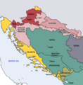
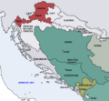
Ficheiro:Map of the Kingdom of Croatia (1868).png
Map_of_the_Kingdom_of_Croatia_(1868).png (542 × 502 píxeis, tamanho: 40 kB, tipo MIME: image/png)
Histórico do ficheiro
Clique uma data e hora para ver o ficheiro tal como ele se encontrava nessa altura.
| Data e hora | Miniatura | Dimensões | Utilizador | Comentário | |
|---|---|---|---|---|---|
| atual | 18h35min de 10 de novembro de 2022 |  | 542 × 502 (40 kB) | CarRadovan | Reverted to version as of 22:47, 17 December 2016 (UTC) |
| 04h43min de 12 de fevereiro de 2017 |  | 542 × 552 (39 kB) | Ceha | Reverted to version as of 10:26, 17 December 2016 (UTC) as discussed before | |
| 22h47min de 17 de dezembro de 2016 |  | 542 × 502 (40 kB) | Lilic | Reverted to version as of 11:51, 13 October 2009 (UTC) reverting to author's original map, as it is in fact better | |
| 10h26min de 17 de dezembro de 2016 |  | 542 × 552 (39 kB) | Ceha | Showed croatian aspirations (pale orange), marked Slavonia as area which sended representatives in croatian parliament, as well as military borders which were part (at least in it's names) of Croatia and Slavonia. | |
| 11h51min de 13 de outubro de 2009 |  | 542 × 502 (40 kB) | DIREKTOR | {{Information |Description={{en|1=Map of the Kingdom of Croatia (red) in late 1867 and early 1868 (before the Croatian-Hungarian Nagodba and the establishment of the Kingdom of Croatia-Slavonia). The Kingdom of Slavonia was independent of Croatia at the t | |
| 11h49min de 13 de outubro de 2009 |  | 542 × 502 (40 kB) | DIREKTOR | {{Information |Description={{en|1=Map of the Kingdom of Croatia (red) in late 1867 and early 1868 (before the Croatian-Hungarian Nagodba and the establishment of the Kingdom of Croatia-Slavonia). The Kingdom of Slavonia was independent of Croatia at the t | |
| 11h45min de 13 de outubro de 2009 |  | 542 × 502 (40 kB) | DIREKTOR | {{Information |Description={{en|1=Map of the Kingdom of Croatia (red) in late 1867 and early 1868 (before the Croatian-Hungarian Nagodba and the establishment of the Kingdom of Croatia-Slavonia). The Kingdom of Slavonia was independent of Croatia at the t | |
| 10h04min de 11 de outubro de 2009 |  | 542 × 502 (39 kB) | DIREKTOR | {{Information |Description={{en|1=Map of the Kingdom of Croatia (red) in late 1867 and early 1868 (before the Croatian-Hungarian Nagodba and the establishment of the Kingdom of Croatia-Slavonia). The Kingdom of Slavonia was independent of Croatia at the t | |
| 16h39min de 8 de outubro de 2009 |  | 542 × 502 (38 kB) | DIREKTOR | {{Information |Description={{en|1=Map of the Kingdom of Croatia (red) in late 1867 and early 1868 (before the Croatian-Hungarian Nagodba and the establishment of the Kingdom of Croatia-Slavonia). The Kingdom of Slavonia was independent of Croatia at the t | |
| 12h47min de 8 de outubro de 2009 |  | 542 × 502 (38 kB) | DIREKTOR | {{Information |Description={{en|1=Map of the Kingdom of Croatia (red) in late 1867 and early 1868 (before the Croatian-Hungarian Nagodba and the establishment of the Kingdom of Croatia-Slavonia). The Kingdom of Slavonia was independent of Croatia at the t |
Utilização local do ficheiro
A seguinte página usa este ficheiro:
Utilização global do ficheiro
As seguintes wikis usam este ficheiro:
- azb.wikipedia.org
- bg.wikipedia.org
- bs.wikipedia.org
- cs.wikipedia.org
- el.wikipedia.org
- en.wikipedia.org
- es.wikipedia.org
- et.wikipedia.org
- eu.wikipedia.org
- fi.wikipedia.org
- hu.wikipedia.org
- it.wikipedia.org
- ja.wikipedia.org
- ko.wikipedia.org
- lv.wikipedia.org
- mk.wikipedia.org
- nl.wikipedia.org
- ro.wikipedia.org
- ru.wikipedia.org
- sh.wikipedia.org
- sl.wikipedia.org
- sr.wikipedia.org
- sv.wikipedia.org
- tr.wikipedia.org
- uk.wikipedia.org
- www.wikidata.org

