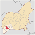
Português: Mapa mostrando o bairro oficial de Centro em vermelho, localizado dentro do Distrito de Guarulhos, no Município de Guarulhos, Estado de São Paulo, Brasil.
O Distrito de Jardim Presidente Dutra (que também é parte de Guarulhos, porém desmembrada de seu distrito sede, como mostra a Lei n° 3.198 de 23/12/1981) está pintada no mapa com uma cor semelhante ao amarelo escuro (#f5e3ba), para representar que o foco principal do mapa (Centro, em vermelho #d92b3f) não é parte daquele distrito.
O Aeroporto Internacional de São Paulo em Guarulhos também está marcado no mapa com a cor #fce9cf, sendo um pouco mais clara do que o amarelo claro do Distrito de Guarulhos (#fff3e3), para representar que apesar de não ser um bairro, o aeroporto também faz parte do mesmo distrito que o foco principal do mapa (Centro, em vermelho).
English: Locator map showing the Centro (literally "Centre" or "Downtown") bairro* in red, located inside the District of Guarulhos, at the Municipality of Guarulhos, State of São Paulo, Brazil.
The District of Jardim Presidente Dutra (also part of the Municipality of Guarulhos) is painted with a dark yellow color (HEX f5e3ba), to represent that the main focus of the map (Centro, in red [#d92b3f]) is not part of that district.
The GRU São Paulo/Guarulhos International Airport is also highlighted on the map with the HEX Color fce9cf, being a little more brighter than the light yellow of the District of Guarulhos (fff3e3), to represent that although it is not a bairro, it also shares the same district as the main focus of the map (in red).
Note: *Bairro = In Brazilian Portuguese, the term may have different meanings depending of the city. The literal translation to 'Bairro' would be 'neighborhood', however, in the case of Guarulhos, at least officialy, it is used to represent the "administrative regions" of the city. Officialy, the equivalent of a neighborhood in Guarulhos would be the "Loteamentos"/"Vizinhanças" (subdivisions/neighborhood), however, these don't have definitive borders and are much smaller than a Bairro. The most close to this would be 'borough', or 'district', however a borough is usually much bigger than a bairro from Guarulhos, and a 'district' in Brazil is regulated usually under federal or state laws, it would also be in conflict with the two districts of Guarulhos: Jardim Presidente Dutra and Guarulhos).
Information Sources: GuaruGeo (Prefecture [executive branch] of Guarulhos), IBGE Maps Portal (2010).


