
Ficheiro:Nansen Greenland Crossing Map.png

Dimensões desta antevisão: 550 × 599 píxeis. Outras resoluções: 220 × 240 píxeis | 626 × 682 píxeis.
Imagem numa resolução maior (626 × 682 píxeis, tamanho: 55 kB, tipo MIME: image/png)
|
|
Esta imagem provém do Wikimedia Commons, um acervo de conteúdo livre da Wikimedia Foundation que pode ser utilizado por outros projetos.
|
Descrição do ficheiro
| Descrição |
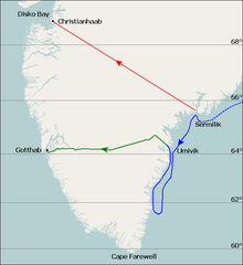
English: Map of Fridtjof Nansen's 1888 route across Greenland, the first crossing of the island.
Dotted line is the ship Jason's journey from Iceland to near Sermilik fjord (now known as Sermiligaaq), continuous blue line is the journey made by Nansen and his companions in two small boats trying to reach the coast. Planned journey from Sermilik northwest to Christianhaab (today known as Qasigiannguit). Nansen's actual journey across Greenland from Umivik fjord to Gothaab (today known as Nuuk). Deutsch: Die gepunktete Linie zeigt die Fahrt der Jason bis zum 17. Juli. Die durchgezogene Linie zeigt die Eisdrift bis zum 29. Juli und die Küstenwanderung bis zum 11. August. Die ursprünglich geplante Route von Sermilik nach Christianshåb. Die wirkliche Route vom 15. August bis 3. Oktober. |
| Data | |
| Origem | Base map is File:Location map Greenland Southern.png, sea (blue) and land (green) journey lines based on File:NansenGreenlandrevisedMap.jpg, published 1888. Latitude lines based on Google Earth sateliite photos. |
| Autor | Base map is from OpenStreetMap by User:Dr. Blofeld, labels, latitude lines, and journey lines added by Ruhrfisch (talk) |
| Permissão (Reutilizar este ficheiro) |
GFDL, CC-BY-SA |
| Outras versões |
 |
Licenciamento
Eu, titular dos direitos de autor desta obra, publico-a com as seguintes licenças:

|
É concedida permissão para copiar, distribuir e/ou modificar este documento nos termos da Licença de Documentação Livre GNU, versão 1.2 ou qualquer versão posterior publicada pela Free Software Foundation; sem Secções Invariantes, sem textos de Capa e sem textos de Contra-Capa. É incluída uma cópia da licença na secção intitulada GNU Free Documentation License. |
This file is licensed under the Creative Commons Attribution-Share Alike 4.0 International, 3.0 Unported, 2.5 Generic, 2.0 Generic and 1.0 Generic license.
- Pode:
- partilhar – copiar, distribuir e transmitir a obra
- recombinar – criar obras derivadas
- De acordo com as seguintes condições:
- atribuição – Tem de fazer a devida atribuição da autoria, fornecer uma hiperligação para a licença e indicar se foram feitas alterações. Pode fazê-lo de qualquer forma razoável, mas não de forma a sugerir que o licenciador o apoia ou subscreve o seu uso da obra.
- partilha nos termos da mesma licença – Se remisturar, transformar ou ampliar o conteúdo, tem de distribuir as suas contribuições com a mesma licença ou uma licença compatível com a original.
Pode escolher a licença que quiser.
Histórico do ficheiro
Clique uma data e hora para ver o ficheiro tal como ele se encontrava nessa altura.
| Data e hora | Miniatura | Dimensões | Utilizador | Comentário | |
|---|---|---|---|---|---|
| atual | 21h08min de 7 de agosto de 2010 | | 626 × 682 (55 kB) | Ruhrfisch | Extend green line along fjord to Godthab, make blue line dotted at first. All other information is the same. |
| 14h54min de 7 de agosto de 2010 |  | 626 × 682 (55 kB) | Ruhrfisch | {{Information |Description= Map of Fridtjof Nansen's 1888 route across Greenland, the first crosing of the island. Ocean journey is blue, land journey is green, proposed original journey route is red. |Source= Base map is [[:File:Location map Greenland So |
Utilização local do ficheiro
A seguinte página usa este ficheiro:
Utilização global do ficheiro
As seguintes wikis usam este ficheiro:
- ba.wikipedia.org
- be.wikipedia.org
- bg.wikipedia.org
- de.wikipedia.org
- en.wikipedia.org
- eo.wikipedia.org
- es.wikipedia.org
- fr.wikipedia.org
- he.wikipedia.org
- hr.wikipedia.org
- hy.wikipedia.org
- id.wikipedia.org
- nn.wikipedia.org
- ro.wikipedia.org
- rue.wikipedia.org
- ru.wikipedia.org
- sl.wikipedia.org
- ta.wikipedia.org
- uk.wikipedia.org