
Ficheiro:NintokuTomb.jpg

Dimensões desta antevisão: 600 × 600 píxeis. Outras resoluções: 240 × 240 píxeis | 480 × 480 píxeis | 769 × 768 píxeis | 1 025 × 1 024 píxeis | 1 345 × 1 344 píxeis.
Imagem numa resolução maior (1 345 × 1 344 píxeis, tamanho: 2,38 MB, tipo MIME: image/jpeg)
|
|
Esta imagem provém do Wikimedia Commons, um acervo de conteúdo livre da Wikimedia Foundation que pode ser utilizado por outros projetos.
|
| Descrição |
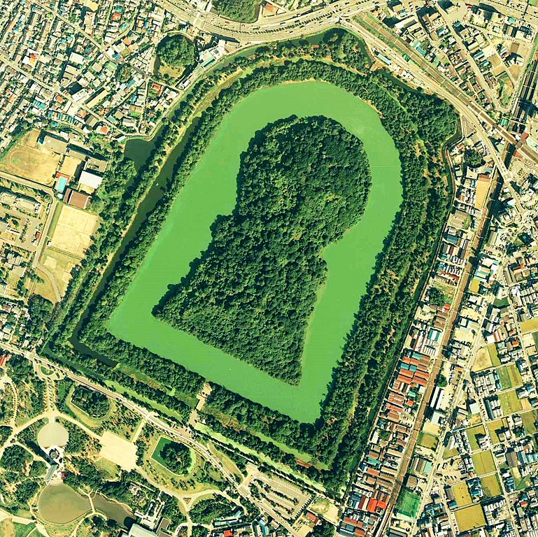
Daisen-kofun in Sakai, Osaka, Japan. This is one of the largest tombs in the world. Japanese government regards this as the tomb of Emperor Nintoku, the 16th emperor, but many historians don't think so. The keyhole-like tomb is 486m long, 305m wide at the bottom and 245m in diameter. English: Daisen-Kofun, the tomb of Emperor Nintoku, Osaka
Español: El Daisen-Kofun, tumba legendaria de Emperador Nintoku
Suomi: Kofun-kauden hautakumpu Osakassa, yksi maailman suurimmista. |
| Data | |
| Origem | http://w3land.mlit.go.jp/cgi-bin/WebGIS2/WC_AirPhoto.cgi?IT=p&DT=n&PFN=CKK-85-2&PCN=C2&IDX=8 |
| Autor | Ministry of Land, Infrastructure and Transport Government of Japan & moja resized |
| Permissão (Reutilizar este ficheiro) |
GFDL |
| Localização da câmara | | Esta e outras imagens nas suas localizações em: OpenStreetMap |
|---|
- 仁徳天皇陵とされる古墳
- ソース
- 整理番号:CKK852-C2-8
- 撮影:1985年(昭和60年)

|
O titular dos direitos de autor deste ficheiro, the Ministry of Land, Infrastructure, Transport and Tourism of Japan, autoriza o seu uso por qualquer pessoa para qualquer finalidade, com a condição de que a sua autoria seja devidamente atribuída. A redistribuição, obras derivadas, uso comercial e todos os demais usos são permitidos. |
Atribuição:
Copyright © National Land Image Information (Color Aerial Photographs), Ministry of Land, Infrastructure, Transport and Tourism
|
 |
This image is copyrighted by the Ministry of Land, Infrastructure, Transport and Tourism of Japan. For terms of use, see the stipulation to use of National Land Information (in Japanese) and message from MLIT (in Japanese and English). When you display this image on an article, include the following phrase in the description: "Made based on National Land Image Information (Color Aerial Photographs), Ministry of Land, Infrastructure, Transport and Tourism".
|
Histórico do ficheiro
Clique uma data e hora para ver o ficheiro tal como ele se encontrava nessa altura.
| Data e hora | Miniatura | Dimensões | Utilizador | Comentário | |
|---|---|---|---|---|---|
| atual | 09h19min de 7 de junho de 2020 | | 1 345 × 1 344 (2,38 MB) | 名古屋太郎 | 明るさ等変更 |
| 20h44min de 17 de agosto de 2005 |  | 800 × 800 (515 kB) | Moja~commonswiki | {{Information| |Description=Daisen-kofun in Sakai, Osaka, Japan. This is one of the largest tombs in the world. Japanese gorvernment regards this as the tomb of Emperor Nintoku, the 16th emperor, but many historians doubt don't think so. The keyhole-lik |
Utilização local do ficheiro
Não há nenhuma página que use este ficheiro.
Utilização global do ficheiro
As seguintes wikis usam este ficheiro:
- en.wikipedia.org
- fr.wikipedia.org
- ja.wikipedia.org
- www.wikidata.org
- zh.wikipedia.org