
Ficheiro:Theoretical map of Romanian origins.png

Dimensões desta antevisão: 776 × 600 píxeis. Outras resoluções: 311 × 240 píxeis | 621 × 480 píxeis | 972 × 751 píxeis.
Imagem numa resolução maior (972 × 751 píxeis, tamanho: 705 kB, tipo MIME: image/png)
|
|
Esta imagem provém do Wikimedia Commons, um acervo de conteúdo livre da Wikimedia Foundation que pode ser utilizado por outros projetos.
|
Descrição do ficheiro
| Descrição |
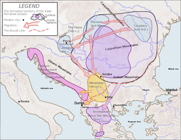
English: Map of the general areas of the ethnogenesis of the Romanian & Albanian peoples since the linguistic hypothesis of the Daco-Thracian origin of the Albanian language (the other hypothesis supposes an Illyrian origin). Data from: Carlos Quiles, A Grammar of Modern Indo-European, ISBN 8461176391, page 76, fig. 47, and Asterios Koukoudis, The Vlachs : Metropolis and Diaspora, éd. Zitros, Thessaloniki 2003, ISBN: 9789607760869 according with Theophanos Confessor, Georgios Cedrenos and Apokaukos.
I slightly fixed the shape of Italy. Image remains in public domain. GhePeU 22:08, 12 February 2006 (UTC) |
||
| Data | |||
| Origem | Obra do próprio | ||
| Autor | User:Ryanaxp | ||
| Permissão (Reutilizar este ficheiro) |
|
||
| Outras versões |
 |
Histórico do ficheiro
Clique uma data e hora para ver o ficheiro tal como ele se encontrava nessa altura.
| Data e hora | Miniatura | Dimensões | Utilizador | Comentário | |
|---|---|---|---|---|---|
| atual | 07h27min de 15 de fevereiro de 2021 | | 972 × 751 (705 kB) | Demetrios1993 | Extended the Jirecek line above Durres, like it was before. It was obviously taken out by mistake when Megistias replaced "Epidamnus" with "Durres". |
| 10h30min de 20 de julho de 2018 |  | 972 × 751 (602 kB) | Trecătorul răcit | Add Megali & Mikri Valacheia (Μεγάλη, Μικρή Βλαχία) since Theophanos Confessor, Georgios Cedrenos and Apokaukos according with Asterios Koukoudis, ''The Vlachs : Metropolis and Diaspora'', éd. Zitros, Thessaloniki 2003, ISBN: 9789607760869. | |
| 10h27min de 25 de outubro de 2015 |  | 972 × 675 (562 kB) | Spiridon Ion Cepleanu | Little cosmetic changes again (colours, shoreline) | |
| 15h58min de 26 de abril de 2015 |  | 972 × 675 (567 kB) | Spiridon Ion Cepleanu | Little cosmetic changes (arrows, areas) | |
| 17h16min de 20 de março de 2013 |  | 972 × 675 (564 kB) | Spiridon Ion Cepleanu | Little changes since Mircea Cociu : Spațiul etnic românesc, ed. Militară, Bucharest 1993, ISBN 973-32-0367-X, containing maps since Jireček, Petrović, Popp, Pușcariu & Rosetti | |
| 14h32min de 15 de fevereiro de 2010 |  | 972 × 675 (573 kB) | Megistias | Modern city name for Istanbul and Durres | |
| 22h42min de 15 de setembro de 2009 |  | 972 × 675 (573 kB) | Megistias | Minor tweak(aesthetic in image edge) | |
| 13h59min de 2 de janeiro de 2008 |  | 972 × 675 (572 kB) | Megistias | This is a map of the general areas in which ethnogenesis of the Romanian people is believed to have occured. It was drawn by me, User:Ryanaxp, on July 31, 2005, and is hereby released into the public domain.{{pd-self}} I slightly fixed the shape of | |
| 22h06min de 12 de fevereiro de 2006 |  | 972 × 675 (574 kB) | GhePeU | ||
| 04h19min de 31 de julho de 2005 |  | 972 × 675 (689 kB) | Ryanaxp | This is a map of the general areas in which ethnogenesis of the Romanian people is believed to have occured. It was drawn by me, User:Ryanaxp, on July 31, 2005, and is hereby released into the public domain. {{pd}} |
Utilização local do ficheiro
A seguinte página usa este ficheiro:
Utilização global do ficheiro
As seguintes wikis usam este ficheiro:
- af.wikipedia.org
- ast.wikipedia.org
- ba.wikipedia.org
- bg.wikipedia.org
- ca.wikipedia.org
- ce.wikipedia.org
- cs.wikipedia.org
- cv.wikipedia.org
- de.wikipedia.org
- en.wikipedia.org
- eo.wikipedia.org
- es.wikipedia.org
- fr.wikipedia.org
- gl.wikipedia.org
- he.wikipedia.org
- hr.wikipedia.org
- id.wikipedia.org
- it.wikipedia.org
- ja.wikipedia.org
- ka.wikipedia.org
- ko.wikipedia.org
- lt.wikipedia.org
- nl.wikipedia.org
- pl.wikipedia.org
- ro.wikipedia.org
- ru.wikipedia.org
Ver mais utilizações globais deste ficheiro.