
Ficheiro:CanalZone.png

Dimensões desta antevisão: 440 × 599 píxeis. Outras resoluções: 176 × 240 píxeis | 520 × 708 píxeis.
Imagem numa resolução maior (520 × 708 píxeis, tamanho: 265 kB, tipo MIME: image/png)
|
|
Esta imagem provém do Wikimedia Commons, um acervo de conteúdo livre da Wikimedia Foundation que pode ser utilizado por outros projetos.
|
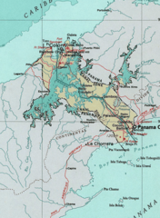
Map of the Panama Canal Zone. from the National Atlas cópia arquivada at the Wayback Machine via American Memory.
This map was obtained from an edition of the National Atlas of the United States. Like almost all works of the U.S. federal government, works from the National Atlas are in the public domain in the United States.
Online access: NationalAtlas.gov | 1970 print edition: Library of Congress, Perry-Castañeda Library
|
Registo de carregamento original
| Data e hora | Dimensões | Utilizador | Comentário |
|---|---|---|---|
| 29 de abril de 2005, 04:29:04 | 520 × 708 (314279 bytes) | Hoshie (discussão · contribs) | Map of the Panama Canal Zone. from the [http://www.nationalatlas.gov/ National Atlas] via [http://memory.loc.gov/ammem/gmdhtml/census3.html American Memory]. {{PD-USGov-Atlas}} |
Histórico do ficheiro
Clique uma data e hora para ver o ficheiro tal como ele se encontrava nessa altura.
| Data e hora | Miniatura | Dimensões | Utilizador | Comentário | |
|---|---|---|---|---|---|
| atual | 09h24min de 1 de outubro de 2014 | | 520 × 708 (265 kB) | RokerHRO | optipng -o7 → 23.74% decrease |
| 10h52min de 29 de agosto de 2014 |  | 520 × 708 (348 kB) | GifTagger | Bot: Converting file to superior PNG file. (Source: CanalZone.gif). This GIF was problematic due to non-greyscale color table. |
Utilização local do ficheiro
As seguintes 3 páginas usam este ficheiro:
Utilização global do ficheiro
As seguintes wikis usam este ficheiro:
- ang.wikipedia.org
- ar.wikipedia.org
- be.wikipedia.org
- bg.wikipedia.org
- bn.wikipedia.org
- ca.wikipedia.org
- cs.wikipedia.org
- da.wikipedia.org
- de.wikipedia.org
- en.wikipedia.org
- eo.wikipedia.org
- es.wikipedia.org
- fa.wikipedia.org
- fr.wikipedia.org
- he.wikipedia.org
- hu.wikipedia.org
- id.wikipedia.org
- it.wikipedia.org
- ja.wikipedia.org
- ka.wikipedia.org
- ko.wikipedia.org
Ver mais utilizações globais deste ficheiro.