
Ficheiro:Cape Helles landing map.jpg
Dimensões desta antevisão: 789 × 599 píxeis. Outras resoluções: 316 × 240 píxeis | 632 × 480 píxeis | 845 × 642 píxeis.
Imagem numa resolução maior (845 × 642 píxeis, tamanho: 72 kB, tipo MIME: image/jpeg)
|
|
Esta imagem provém do Wikimedia Commons, um acervo de conteúdo livre da Wikimedia Foundation que pode ser utilizado por outros projetos.
|
Descrição do ficheiro
| Descrição |
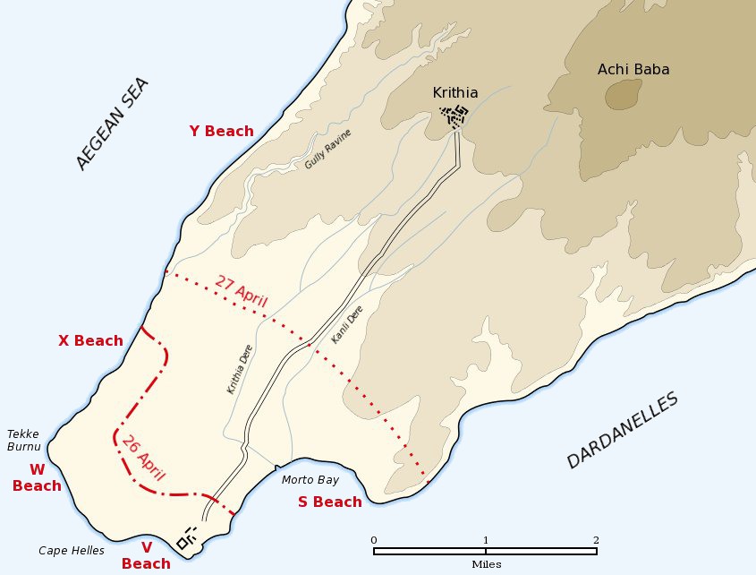
English: Map of the landing of the British 29th Division at Cape Helles on April 25, 1915 during the Battle of Gallipoli. The front line established by the night of April 26 is shown by the red dash-dot line. The front line reached by the night of April 27 is shown by the red dotted line. This became the "jumping off" line for the First Battle of Krithia. |
||
| Data | |||
| Origem | Self created from map [1] in Hamilton, Ian (1920) Gallipoli Diary, Volume I, Category:New York: George H Doran Company | ||
| Autor | Gsl | ||
| Permissão (Reutilizar este ficheiro) |
|
||
| Outras versões |
|


![[1]](http://gutenberg.readingroo.ms/1/9/3/1/19317/19317-h/images/img-map.jpg)
Registo de carregamento original
A página de descrição original está Helles landing map.jpg aqui. Todos os nomes de utilizador a seguir referem-se a en.wikipedia.
- 2004-05-16 06:37 Gsl 845×642× (64213 bytes)
Histórico do ficheiro
Clique uma data e hora para ver o ficheiro tal como ele se encontrava nessa altura.
| Data e hora | Miniatura | Dimensões | Utilizador | Comentário | |
|---|---|---|---|---|---|
| atual | 18h20min de 21 de junho de 2012 | | 845 × 642 (72 kB) | Hohum | Sea to blue |
| 15h04min de 6 de maio de 2005 |  | 845 × 642 (63 kB) | Anathema | Map of the landing of the British 29th Division at Cape Helles, Gallipoli, on April 25, 1915. The front line established by the night of April 26 is shown by the red dash-dot line. The front line reached by the night of April 27 is shown by the red |
Utilização local do ficheiro
As seguintes 2 páginas usam este ficheiro:
Utilização global do ficheiro
As seguintes wikis usam este ficheiro:
- ar.wikipedia.org
- ast.wikipedia.org
- bg.wikipedia.org
- ca.wikipedia.org
- cs.wikipedia.org
- da.wikipedia.org
- de.wikipedia.org
- en.wikipedia.org
- fr.wikipedia.org
- fy.wikipedia.org
- he.wikipedia.org
- id.wikipedia.org
- io.wikipedia.org
- it.wikipedia.org
- ko.wikipedia.org
- no.wikipedia.org
- pl.wikipedia.org
- ro.wikipedia.org
- ru.wikipedia.org
- sr.wikipedia.org
- uk.wikipedia.org