
Ficheiro:Catarina 27 mar 2004 1355Z.jpg

Dimensões desta antevisão: 776 × 600 píxeis. Outras resoluções: 311 × 240 píxeis | 621 × 480 píxeis | 994 × 768 píxeis | 1 280 × 989 píxeis | 2 560 × 1 978 píxeis | 4 400 × 3 400 píxeis.
Imagem numa resolução maior (4 400 × 3 400 píxeis, tamanho: 2,85 MB, tipo MIME: image/jpeg)
|
|
Esta imagem provém do Wikimedia Commons, um acervo de conteúdo livre da Wikimedia Foundation que pode ser utilizado por outros projetos.
|
Descrição do ficheiro
| Descrição |
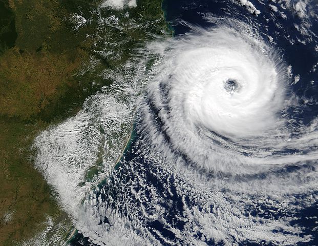
The Moderate Resolution Imaging Spectroradiometer (MODIS) onboard NASA’s Aqua satellite captured this true-color image of a rare tropical cyclone in the South Atlantic ocean just off the coast of Santa Catarina and Rio Grande do Sul, Brazil’s southernmost states on March 27, 2004. The National Hurricane Center in Miami estimated the storm was a full-fledged, Category I hurricane with central winds between 75 mph and 80 mph (121 kph to 129 kph), making it the first hurricane in the South Atlantic in recorded history. Brazilian scientists however, have disagreed, saying the storm had top winds of 50 mph to 56 mph (80 kph to 90 kph), far below the 75 mph (121 kph) threshold of a hurricane. It's interesting to note that the Brazilian Center for Weather Prediction and Climatic Studies does not operate any anemometers (wind measuring devices) in the area or have any Hurricane Hunter aircraft to fly through the storm. All sides were basing their guesses on satellite data only. |
|||||
| Data | ||||||
| Origem | http://visibleearth.nasa.gov/view_rec.php?id=6446 | |||||
| Autor | Jacques Descloitres, MODIS Rapid Response Team, NASA/GSFC | |||||
| Permissão (Reutilizar este ficheiro) |
|

Histórico do ficheiro
Clique uma data e hora para ver o ficheiro tal como ele se encontrava nessa altura.
| Data e hora | Miniatura | Dimensões | Utilizador | Comentário | |
|---|---|---|---|---|---|
| atual | 20h01min de 26 de novembro de 2006 | | 4 400 × 3 400 (2,85 MB) | Good kitty | == Summary == {{Information |Description=The Moderate Resolution Imaging Spectroradiometer (MODIS) onboard NASA’s Aqua satellite captured this true-color image of a rare tropical cyclone in the South Atlantic ocean just off the coast of Santa Catarina a |
Utilização local do ficheiro
A seguinte página usa este ficheiro:
Utilização global do ficheiro
As seguintes wikis usam este ficheiro:
- he.wikipedia.org
- www.wikidata.org