
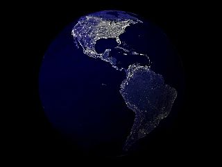
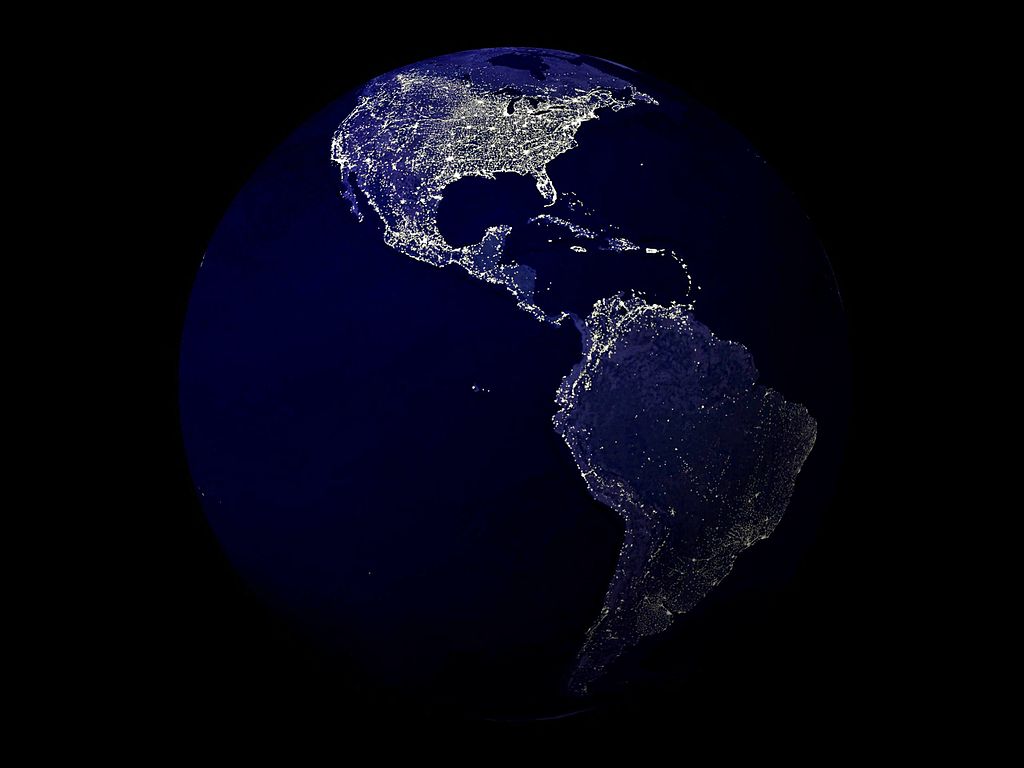
Ficheiro:Earth at Night 2001.jpg

Dimensões desta antevisão: 800 × 600 píxeis. Outras resoluções: 320 × 240 píxeis | 640 × 480 píxeis | 1 024 × 768 píxeis | 1 280 × 960 píxeis | 2 560 × 1 920 píxeis.
Imagem numa resolução maior (2 560 × 1 920 píxeis, tamanho: 702 kB, tipo MIME: image/jpeg)
|
|
Esta imagem provém do Wikimedia Commons, um acervo de conteúdo livre da Wikimedia Foundation que pode ser utilizado por outros projetos.
|
Descrição do ficheiro
| Descrição |
English: Collection: NASA Scientific Visualization Studio Collection
Title: Earth at Night 2001 Instrument: DMSP/OLS Description: Human-made lights highlight particularly developed or populated areas of the Earths surface, including the seaboards of Europe, the eastern United States, and Japan. Abstract: This is what the Earth looks like at night. Can you find your favorite country or city? Surprisingly, city lights make this task quite possible. Human-made lights highlight particularly developed or populated areas of the Earth's surface, including the seaboards of Europe, the eastern United States, and Japan. Many large cities are located near rivers or oceans so that they can exchange goods cheaply by boat. Particularly dark areas include the central parts of South America, Africa, Asia, and Australia. The above image is actually a composite of hundreds of pictures made by the Defense Meteorological Satellite Program (DMSP) currently operates four satellites carrying the Operational Linescan System (OLS) in low-altitude polar orbits. Three of these satellites record nighttime data. The DMSP-OLS has a unique capability to detect low levels of visible-near infrared (VNIR) radiance at night. With the OLS 'VIS' band data it is possible to detect clouds illuminated by moonlight, plus lights from cities, towns, industrial sites, gas flares, and ephemeral events such as fires and lightning-illuminate d clouds. The Nighttime Lights of the World data set is compiled from the October 1994 - March 1995 DMSP nighttime data collected when moonlight was low. Using the OLS thermal infrared band, areas containing clouds were removed and the remaining area used in the time series. This animation is derived from an image created by Craig Mayhew and Robert Simmon from data provided by Christopher Elvidge of the NOAA National Geophysical Data Center. |
| Data | |
| Origem | https://www.flickr.com/photos/44494372@N05/5052743604/in/photolist-8GuCD3-8UDNtS-8UDNEY-8So6m7-fgTnWf-adkk1n-adZwTs-bm3JUv-8XU8T3-7obcZF-7of7aj-a5uvxh-a5uvws-a5uvxU-a5rCYB-7Szc97-7Szc9d-7Szc9j-7Sz37h-7Szc9f-7Sz377-7Szc9o-7Sz37b-7Sz37L-7Sz37G-7Szc9h-7Sz37m-9gL7KE-8eH37c-8So5p3-drUPcv-8SjZZK-7cNV8e-8So5B7-8So7sG-8So6Gy-8SjZ22-8Sk1at-8So6wQ-8SjZct-8Sk1nK-8SjY8F-8So5LN-8UDNko-bm3FR6-bixX5D-bm3b7k-biyJiz-bm2iGp-bm2CgX-biyWCZ |
| Autor | NASA |
Licenciamento
| Este ficheiro está no domínio público nos Estados Unidos porque foi criado exclusivamente pela NASA. As orientações sobre o direito de autor da NASA são que «as obras da NASA não têm os direitos de autor protegidos salvo indicação em contrário». Veja Template:PD-USGov, as orientações sobre o direito de autor da NASA ou as normas de uso de imagens do Laboratório de Propulsão a Jato (Jet Propulsion Lab, JPL). | ||
 |
Avisos:
|
Histórico do ficheiro
Clique uma data e hora para ver o ficheiro tal como ele se encontrava nessa altura.
| Data e hora | Miniatura | Dimensões | Utilizador | Comentário | |
|---|---|---|---|---|---|
| atual | 09h12min de 25 de outubro de 2013 | | 2 560 × 1 920 (702 kB) | Chronus | =={{int:filedesc}}== {{Information |description={{en|1=Collection: NASA Scientific Visualization Studio Collection Title: Earth at Night 2001 Instrument: DMSP/OLS Description: Human-made lights highlight particularly developed or populated areas of th... |
| 09h53min de 30 de julho de 2013 |  | 2 560 × 1 920 (237 kB) | Numéro 1963 | User created page with UploadWizard |
Utilização local do ficheiro
A seguinte página usa este ficheiro:
Utilização global do ficheiro
As seguintes wikis usam este ficheiro:
- en.wikiversity.org
- tr.wikipedia.org