
Ficheiro:Germany occupation zones with border.jpg

Dimensões desta antevisão: 722 × 599 píxeis. Outras resoluções: 289 × 240 píxeis | 578 × 480 píxeis | 925 × 768 píxeis | 1 234 × 1 024 píxeis | 1 460 × 1 212 píxeis.
Imagem numa resolução maior (1 460 × 1 212 píxeis, tamanho: 861 kB, tipo MIME: image/jpeg)
|
|
Esta imagem provém do Wikimedia Commons, um acervo de conteúdo livre da Wikimedia Foundation que pode ser utilizado por outros projetos.
|

|
Esta imagem de mapas (ou todas as imagens neste artigo ou categoria) deveriam ser recriadas usando gráficos vectoriais, como ficheiros SVG. Isto tem várias vantagens; veja as Commons:Media for cleanup|imagens para rever para mais informações. Se já criou um ficheiro SVG desta imagem, por favor, carregue-o. Depois do novo ficheiro SVG ter sido carregado, substitua aqui esta predefinição pela predefinição {{vector version available|nome da nova imagem.svg}}.
|


Descrição do ficheiro
| Descrição |
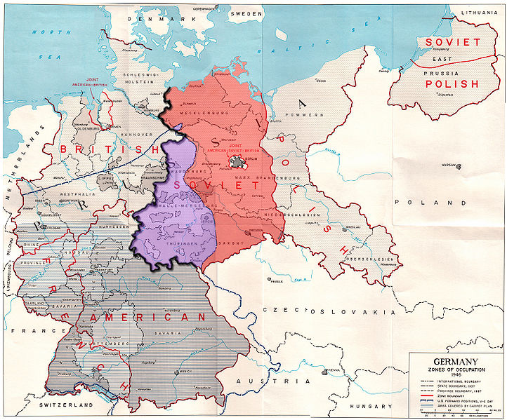
English: Map of the occupation zones of Germany in 1945, modified to show the inner German border and the zone from which Allied forces withdrew in July 1945. From Earl F. Ziemke, The U.S. Army in the Occupation of Germany, 1975. Library of Congress, Catalog Card Number 75-619027.
Deutsch: Karte der Besatzungszonen in Deutschland im Jahr 1945. Sie wurde modifiziert, um die innerdeutsche Grenze und die Zone, aus der sich die Alliierten im Juli 1945 zurückzogen, zu verdeutlichen. Von Earl F. Ziemke, Die US-Armee während der Besetzung Deutschlands, 1975. Kongress-Bibliothek, Katalog-Karten-Nummer 75-619027.
Français : Carte des zones d'occupation de l'Allemagne en 1945, modifié pour montrer la frontière allemande intérieure et la zone d'où les forces alliées se retirèrent en Juillet 1945. De Earl F. Ziemke, l'armée américaine dans l'occupation de l'Allemagne, 1975. Bibliothèque du Congrès, Catalogue Numéro de la carte 75-619027.
Русский: Карта, показывающая зоны оккупации послевоенной Германии, а также линию продвижения американских войск на день капитуляции. Юго-западная часть советской зоны оккупации, около трети её общей площади, находилась западней американских позиций на день капитуляции. Советская зона выделена красным, а область, из которой были отведены в июле 1945 года британские и американские войска — фиолетовым, внутригерманская граница показана жирной чёрной линией. Границы областей показаны в соответствии с территориальным делением Веймарской республики, до современного федерального деления на земли. |
||
| Data | |||
| Origem | Modified version of http://www.globalsecurity.org/military/library/report/other/us-army_germany_1944-46_map3.htm | ||
| Autor | US Army | ||
| Outras versões |
|
Licenciamento
Esta imagem é um trabalho de um soldado ou funcionário do Exército dos Estados Unidos, tirada ou feita durante o curso de uma tarefa oficial. Como trabalho do Governo Federal dos Estados Unidos, a imagem está em domínio público.
|
 |
Histórico do ficheiro
Clique uma data e hora para ver o ficheiro tal como ele se encontrava nessa altura.
| Data e hora | Miniatura | Dimensões | Utilizador | Comentário | |
|---|---|---|---|---|---|
| atual | 23h52min de 24 de setembro de 2009 | | 1 460 × 1 212 (861 kB) | ChrisO | Fixed errors |
| 16h57min de 19 de setembro de 2009 |  | 1 460 × 1 212 (863 kB) | ChrisO | {{Information |Description={{en|1=Map of the occupation zones of Germany in 1945, modified to show the inner German border and the zone from which Allied forces withdrew in July 1945. From Earl F. Ziemke, ''The U.S. Army in the Occupation of Germany'', 19 |
Utilização local do ficheiro
As seguintes 2 páginas usam este ficheiro:
Utilização global do ficheiro
As seguintes wikis usam este ficheiro:
- ar.wikipedia.org
- ast.wikipedia.org
- azb.wikipedia.org
- az.wikipedia.org
- cs.wikipedia.org
- da.wikipedia.org
- de.wikipedia.org
- el.wikipedia.org
- en.wikipedia.org
- es.wikipedia.org
- fa.wikipedia.org
- fr.wikipedia.org
- he.wikipedia.org
- hr.wikipedia.org
- id.wikipedia.org
- it.wikipedia.org
- ka.wikipedia.org
- ko.wikipedia.org
- ml.wikipedia.org
- my.wikipedia.org
- pl.wikipedia.org
- pnb.wikipedia.org
- ru.wikipedia.org
- sv.wikipedia.org
- ta.wikipedia.org
- te.wikipedia.org
- tr.wikipedia.org
Ver mais utilizações globais deste ficheiro.