
Ficheiro:Prince Edward Island map 1775.jpg
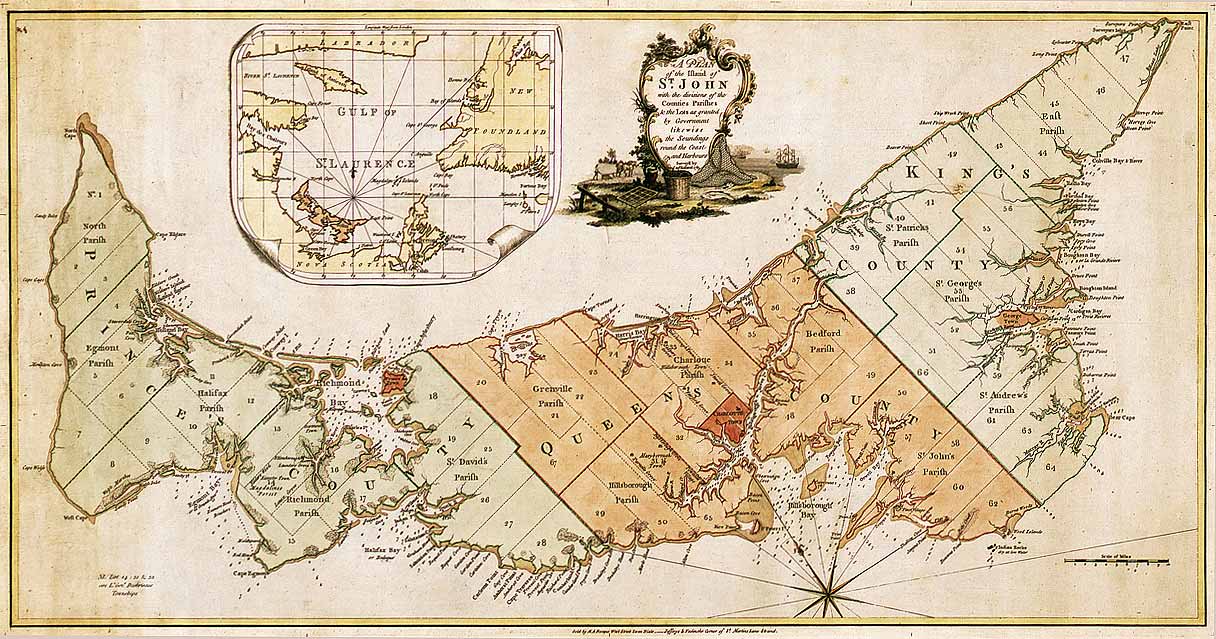
Imagem numa resolução maior (1 216 × 639 píxeis, tamanho: 167 kB, tipo MIME: image/jpeg)
|
|
Esta imagem provém do Wikimedia Commons, um acervo de conteúdo livre da Wikimedia Foundation que pode ser utilizado por outros projetos.
|
Descrição do ficheiro
| Descrição |
English: Map of Prince Edward Island in 1775. Titled: "A plan of the island of St. John with the divisions of the counties parishes & the lots as granted by government likewise the soundings round the coast and harbours. Surveyed by Capt. Holland. 1775." The island was the first of the new English colonies for which a general survey was conducted. Samuel Holland was in charge of the survey. Known as Île Saint-Jean at the time of the French, and later Saint John Island, it did not take its present name until 1799. This very detailed plan shows the projected counties, parishes, townships and lots on the island following the expulsion of the Acadians in 1758. Samuel Holland, surveyor general of the province of Quebec, surveyed the island in the fall of 1764. He identified the location of the capital and named it Charlottetown. The counties and townships are listed with their sizes in acres. Inset map of the Gulf of St. Lawrence. Decorative cartouche showing farming and fishing sceneries. |
||||||||||||||||||||
| Data | |||||||||||||||||||||
| Origem |
|
||||||||||||||||||||
| Autor |
|
||||||||||||||||||||


Licenciamento
|
Esta obra está no domínio público no seu país de origem e noutros países e áreas onde o período de proteção dos direitos de autor é igual ou inferior à vida do autor mais 100 anos. | |
| Este ficheiro foi considerado livre de restrições conhecidas devidas a direitos de autor, incluindo todos os direitos conexos. | |
Histórico do ficheiro
Clique uma data e hora para ver o ficheiro tal como ele se encontrava nessa altura.
| Data e hora | Miniatura | Dimensões | Utilizador | Comentário | |
|---|---|---|---|---|---|
| atual | 01h52min de 6 de dezembro de 2007 | | 1 216 × 639 (167 kB) | SriMesh | |
| 01h51min de 6 de dezembro de 2007 |  | 1 216 × 639 (167 kB) | SriMesh | ||
| 01h45min de 6 de dezembro de 2007 |  | 1 500 × 791 (1,02 MB) | SriMesh | {{Information |Description=Prince Edward Island map 1765 |Source=Library and Archives Canada |Date=2007-12-05 |Author=Holland, Samuel |Permission=unrestricted public domain material, which can be reproduced without permission. |
Utilização local do ficheiro
A seguinte página usa este ficheiro:
Utilização global do ficheiro
As seguintes wikis usam este ficheiro:
- bg.wikipedia.org
- de.wikipedia.org
- en.wikipedia.org
- ka.wikipedia.org
- mk.wikipedia.org
- mn.wikipedia.org
- ro.wikipedia.org