
Ficheiro:Santa lucia anse la raye political.png

Dimensões desta antevisão: 424 × 599 píxeis. Outras resoluções: 170 × 240 píxeis | 339 × 480 píxeis | 733 × 1 036 píxeis.
Imagem numa resolução maior (733 × 1 036 píxeis, tamanho: 20 kB, tipo MIME: image/png)
|
|
Esta imagem provém do Wikimedia Commons, um acervo de conteúdo livre da Wikimedia Foundation que pode ser utilizado por outros projetos.
|
Descrição do ficheiro
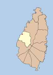
| Descrição | this is a political map showing the quarter of Anse La Raye on the island nation of Santa Lucia. I created it myself by using the GIMP to trace a public domain map that i found at the Perry-Castañeda Library Map Collection. |
| Data | 21 de setembro de 2005 (data de carregamento original) |
| Origem | A fonte não foi fornecida de forma legível por computadores. Presume-se que seja obra própria (com base nos direitos de autor reivindicados). |
| Autor | O autor não foi fornecido de forma legível por computadores. Presume-se que seja Doviende~commonswiki (com base nos direitos de autor reivindicados). |
Licenciamento
| Eu, titular dos direitos de autor desta obra, dedico-a ao domínio público, com aplicação em todo o mundo. Nalguns países isto pode não ser legalmente possível; se assim for: Concedo a todos o direito de usar esta obra para qualquer fim, sem quaisquer condições, a menos que tais condições sejam impostas por lei. |

|
File:Saint Lucia district of Anse-la-Raye.svg é uma versão vetorial deste ficheiro. Ela deve ser usada em vez desta imagem em formato raster, se não for de qualidade inferior.
File:Santa lucia anse la raye political.png → File:Saint Lucia district of Anse-la-Raye.svg
Para mais informações, consulte Ajuda:SVG. |
 |
Histórico do ficheiro
Clique uma data e hora para ver o ficheiro tal como ele se encontrava nessa altura.
| Data e hora | Miniatura | Dimensões | Utilizador | Comentário | |
|---|---|---|---|---|---|
| atual | 03h43min de 21 de setembro de 2005 | | 733 × 1 036 (20 kB) | Doviende~commonswiki | this is a political map showing the quarter of Anse La Raye on the island nation of Santa Lucia. I created it myself by using the GIMP to trace [http://www.lib.utexas.edu/maps/americas/saint_lucia.gif a public domain map that i found] at the Perry-Ca |
| 02h26min de 21 de setembro de 2005 |  | 733 × 1 036 (8 kB) | Doviende~commonswiki | this is a political map showing the quarter of Anse La Raye on the island nation of Santa Lucia. I created it myself by tracing a public domain map that i found at the Perry-Castañeda Library Map Collection. this image is public domain as well. |
Utilização local do ficheiro
A seguinte página usa este ficheiro:
Utilização global do ficheiro
As seguintes wikis usam este ficheiro:
- en.wikipedia.org
- fa.wikipedia.org
- fi.wikipedia.org
- ko.wikipedia.org
- mk.wikipedia.org
- ur.wikipedia.org
- vi.wikipedia.org
- zh.wikipedia.org