
Ficheiro:Satellite image of Bolivia in June 2002.jpg

Dimensões desta antevisão: 521 × 600 píxeis. Outras resoluções: 208 × 240 píxeis | 417 × 480 píxeis | 667 × 768 píxeis | 889 × 1 024 píxeis | 1 778 × 2 048 píxeis | 5 279 × 6 079 píxeis.
Imagem numa resolução maior (5 279 × 6 079 píxeis, tamanho: 4,02 MB, tipo MIME: image/jpeg)
|
|
Esta imagem provém do Wikimedia Commons, um acervo de conteúdo livre da Wikimedia Foundation que pode ser utilizado por outros projetos.
|
Descrição do ficheiro
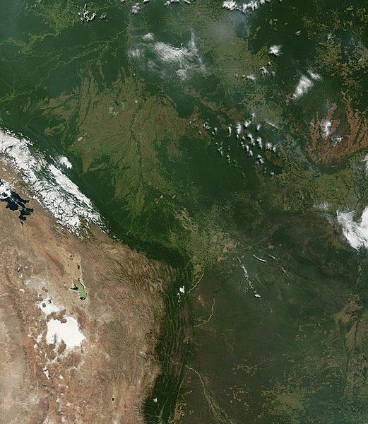
| Descrição | Satellite image of Bolivia in June 2002. Normally obscured by clouds, Bolivia is amazingly clear in this true-color MODIS image acquired June 20, 2002. Bounded by Brazil to the north and east, Paraguay and Argentina to the south, and Peru and Chile to the west, Bolivia is completely landlocked. A good portion of Bolivia is dominated by the Andes, but it also lays claim to lush forests and pasture lands in the Amazon Basin.Bolivia's agricultural crops include soybeans, coffee, coca, cotton, corn, sugarcane, rice, potatoes, and timber. A number of agricultural plots are visible in central Bolivia. Some large plots are arranged in a circular star shape, with water sources at the center and the agricultural plots radiating outwards. Adjacent to them (down and to the right) are more traditional shaped plots (more rectangular).One of Bolivia's main exports is tropical timber. Visible in this image are areas where the timber has been harvested. The deforestation patterns tend to follow major roads first, then smaller roads adjoining main roads. These patterns resemble the growth of ice crystals and are best viewed in the higher resolutions of this image. Deforestation is visible along the green edge of the Andes in central Bolivia. |
| Data | |
| Origem | Slightly cropped from: http://visibleearth.nasa.gov/view_rec.php?id=3261 |
| Autor | Jacques Descloitres, MODIS Land Rapid Response Team, NASA/GSFC |
Licenciamento
| Este ficheiro está no domínio público nos Estados Unidos porque foi criado exclusivamente pela NASA. As orientações sobre o direito de autor da NASA são que «as obras da NASA não têm os direitos de autor protegidos salvo indicação em contrário». Veja Template:PD-USGov, as orientações sobre o direito de autor da NASA ou as normas de uso de imagens do Laboratório de Propulsão a Jato (Jet Propulsion Lab, JPL). | ||
 |
Avisos:
|
Histórico do ficheiro
Clique uma data e hora para ver o ficheiro tal como ele se encontrava nessa altura.
| Data e hora | Miniatura | Dimensões | Utilizador | Comentário | |
|---|---|---|---|---|---|
| atual | 16h40min de 18 de dezembro de 2004 | | 5 279 × 6 079 (4,02 MB) | Hautala | {{PD-USGov-NASA}} Satellite image of Bolivia in June 2002. Slightly cropped image taken originally from http://visibleearth.nasa.gov/cgi-bin/viewrecord?16839 . Normally obscured by clouds, Bolivia is amazingly clear in this true-color MODIS image acquired |
Utilização local do ficheiro
Não há nenhuma página que use este ficheiro.
Utilização global do ficheiro
As seguintes wikis usam este ficheiro:
- af.wikipedia.org
- ast.wikipedia.org
- de.wikipedia.org
- dz.wikipedia.org
- en.wikipedia.org
- es.wikipedia.org
- fr.wikipedia.org
- gcr.wikipedia.org
- hi.wikipedia.org
- hr.wikipedia.org
- ne.wikipedia.org
- qu.wikipedia.org
- sr.wikipedia.org
- te.wikipedia.org
- uk.wikipedia.org