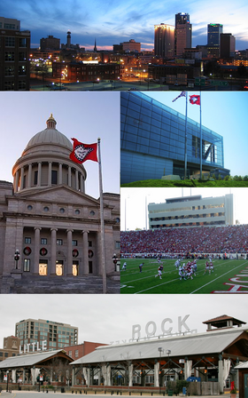
Little Rock
| ||||
---|---|---|---|---|
Capital e cidade do Arkansas | ||||
O Centro Presidencial Clinton e a biblioteca, em Little Rock | ||||
Símbolos | ||||
| ||||
Apelido(s) | Monument City, Charm City, Mob Town, e B-more | |||
Gentílico | Little Rocker | |||
Localização | ||||
Localização no condado de Pulaski | ||||
Localização nos Estados Unidos | ||||
Localização no Arkansas | ||||
Mapa de Little Rock | ||||
Coordenadas | ||||
País | Estados Unidos | |||
Estado | Arkansas | |||
Condado | Pulaski | |||
Municipalidade | Big Rock | |||
História | ||||
Fundação | 1 de junho de 1821 (199 anos) | |||
Incorporação (vila) | 7 de novembro de 1831 (189 anos) | |||
Incorporação (cidade) | 2 de novembro de 1835 (185 anos) | |||
Nomeado por | em francês: La Petite Roche (a pequena rocha) | |||
Administração | ||||
Prefeito | Frank Scott Jr. (D) (desde 1 de janeiro de 2019) | |||
Características geográficas | ||||
Área total | 318,44 km² | |||
• Área seca | 310,77 km² | |||
• Área molhada | 7,67 km² | |||
• Área metropolitana | 10 593,94 km² | |||
População total (2010) [1] | 193 524 hab. | |||
• Estimativa (2019) | 197 312 | |||
• População urbana | 431 388 | |||
• População metropolitana | 738 344 | |||
Densidade | 607,7 hab./km² | |||
Altitude | 102 m | |||
Fuso horário | UTC−6 | |||
Horário de verão | UTC−5 | |||
ZIP Codes | 72002, 72103, 72201, 72202, 72204, 72205, 72206, 72207, 72209, 72210, 72211, 72212, 72223, 72227 | |||
Códigos da área | 501 | |||
Outras informações | ||||
Código FIPS | 05-41000 | |||
Código GNIS | 83350 | |||
Aeroporto principal | LIT | |||
Interestaduais | ![]() ![]() ![]() ![]() ![]() ![]() | |||
U.S. Routes | ![]() ![]() ![]() ![]() ![]() | |||
Sítio | www |
Little Rock é a capital e cidade mais populosa do estado norte-americano do Arkansas. É a sede do condado de Pulaski. Foi fundada em 1 de junho de 1821 e incorporada como vila em 1831, e posteriormente como cidade em 2 de novembro de 1835.
Situada perto do centro geográfico do estado do Arkansas, o nome Little Rock deriva do nome de uma pedra pequena que existe na margem sul do rio Arkansas, chamada em francês de la petite roche (em português, a pequena rocha).
História[editar | editar código-fonte]
Em 1772 um explorador francês chamado Bernard de la Harpe encontrou uma pequena rocha ao lado do rio Arkansas, e deu-lhe o nome de la petite roche, e ordenou a construção de um posto comercial no local. Em 1819 fundou-se a cidade de Little Rock, que viria em 1821 a tornar-se a capital do estado do Arkansas, tendo a construção do capitólio da cidade iniciado apenas em 1911.
Durante a Guerra Civil Americana, Little Rock juntou-se aos Estados Confederados da América.
Em 1957 ocorreram grandes distúrbios num instituto de Little Rock. Os distúrbios foram tão grandes, que o Exército dos Estados Unidos teve de intervir.
Em 1992, o senador Bill Clinton converteu-se no primeiro natural do estado do Arkansas a tornar-se presidente dos Estados Unidos. As bandas de rock Evanescence e Living Sacrifice são de origem de Little Rock.
Geografia[editar | editar código-fonte]
De acordo com o United States Census Bureau, a cidade tem uma área de 318,4 km², dos quais 310,8 km² estão cobertos por terra e 7,7 km² por água[1].
Demografia[editar | editar código-fonte]
|
Segundo o censo nacional de 2010,[1] a cidade possui 193 524 habitantes, o que a torna a cidade mais populosa do estado. Sua densidade populacional é de 607,7 hab/km². A área metropolitana estatística de Little Rock tem cerca 700 mil habitantes. A cidade possui 91 288 residências, que resulta em uma densidade de 295,7 residências/km².
Marcos históricos[editar | editar código-fonte]
A relação a seguir lista as 260 entradas do Registro Nacional de Lugares Históricos em Little Rock. O primeiro marco foi designado em 3 de dezembro de 1969 e os mais recentes em 12 de janeiro de 2021.[3] Aqueles marcados com ‡ também são um Marco Histórico Nacional.
- Abrams House
- Absalom Fowler House
- Ada Thompson Memorial Home
- Adrian Brewer Studio
- Albert Pike Hotel
- Albert Pike Memorial Temple
- Albert Retan House
- Alexander House
- Angelo Marre House
- Arkansas Power & Light Building
- Arkansas Territorial Restoration Historic District
- Associated Reformed Presbyterian Church
- Augustus Garland House
- Baer House
- Barlow Apartments
- Beal-Burrow Dry Goods Building
- Bechle Apartment Building
- Beyerlein House
- Bishop Hiram A. Boaz House
- Block 35 Cobblestone Alley
- Block Realty Building
- Block Realty-Baker House
- Boone House
- Boy Scouts of America Building
- Boyle Park
- BPOE Elks Club
- Bragg Guesthouse
- Buhler House
- Bush House
- Bush-Dubisson House
- Capital Hotel
- Capitol-Main Historic District
- Capitólio Estadual do Arkansas
- Carmichael House
- Cecil M. Buffalo Jr., House
- Central High School Neighborhood Historic District
- Central Presbyterian Church
- Charles Clary Waters House
- Chisum House
- Choctaw Route Station
- Climber Motor Car Factory, Unit A
- Compton-Wood House
- Confederate Soldiers Monument
- Cornish House
- Corydon Wassell House
- Croxson House
- Cumberland Towers
- Curran Hall
- Daisy Bates House‡
- Dan Stowers Office Building
- Darragh Building
- Darragh House
- David O. Dodd Memorial
- Deane House
- Democrat Printing & Lithograph Co. Building
- Donaghey Building
- Downs Historic District
- Dr. Eugene Towbin House
- Dr. Morgan Smith House
- Dunaway House
- Dunbar Junior and Senior High School and Junior College
- East Markham Street Historic District
- Empire Life Insurance Company of America Building
- England House
- Exchange Bank Building
- Fair Park Golf Course
- Farrell House
- Farrell House
- Farrell House
- Farrell House
- Federal Building
- Federal Reserve Bank Building
- First Baptist Church
- First Church of Christ, Scientist
- First Hotze House
- First Missionary Baptist Church
- First Presbyterian Church
- First United Methodist Church
- Fletcher House
- Florence Crittenton Home
- Fones House
- Fordyce House
- Frauenthal House
- Fred W. Parris Towers
- Frederick Hanger House
- French-England House
- Fulk Building
- Fulk-Arkansas Democrat Building
- Garland Elementary School
- Gay Oil Company Building
- Gazette Building
- George R. Mann Building
- Governor's Mansion Historic District
- Green House
- Gus Blass Department Store
- Gustave B. Kleinschmidt House
- H.M. Anderson House
- Hall House
- Halliburton Townhouses
- Hanger Hill Historic District
- Hardy House
- Harris House
- Healey and Roth Mortuary Building
- Hemingway House
- Henderson House
- Herschell-Spillman Carousel
- Hillcrest Historic District
- Holcomb Court Apartments
- Hornibrook House
- Hotel Freiderica
- Hotze House
- Isaac Homard House
- J. P. Runyan House
- James Mitchell School
- Jesse Powell Towers
- John Henry Clayborn House
- Johnson House
- Johnson House
- Johnson House
- Johnswood
- Joseph M. Frank House
- Joseph Taylor Robinson House‡
- Joseph Taylor Robinson Memorial Auditorium
- Kahn-Jennings House
- Keith House
- LaFayette Hotel
- Lake Nixon
- Lamar Porter Athletic Field
- Lamb-McSwain House
- Leiper-Scott House
- Lincoln Avenue Viaduct
- Lincoln Building
- Little Rock Boys Club
- Little Rock Central Fire Station
- Little Rock Central High School‡
- Little Rock Central High School National Historic Site
- Little Rock City Hall
- Little Rock Confederate Memorial
- Little Rock Fire Station No. 9
- Little Rock National Cemetery
- Little Rock US Post Office and Courthouse
- Little Rock Y.M.C.A.
- Luxor Apartments
- MacArthur Park Historic District
- Magnolia Service Station
- Main Building, Arkansas Baptist College
- Main Street Commercial District
- Marshall House
- Marshall Square Historic District
- Martin Cemetery Historic Section
- Mary H. Matthews Lustron House
- Maxwell F. Mayer House
- McDonald-Wait-Newton House
- McLean House
- Mehaffey House
- Memorial to Company A, Capitol Guards
- Miller House
- Mims-Breedlove-Priest-Weatherton House
- Minnesota Monument
- Mitchell House
- Monument to Confederate Women
- Moore Building
- Moore House
- Mopac Station
- Mosaic Templars State Temple
- Mount Holly Cemetery
- Mount Holly Mausoleum
- Mount Zion Baptist Church
- Nash House
- Nash House
- National Old Line Insurance Company Building
- Newbill-Porter House
- Noland Blass Jr., House
- Oak Forest United Methodist Churc
- Oakland-Fraternal Cemetery
- Old Post Office Building and Customhouse
- Old State House‡
- Parnell Hall
- Paul Laurence Dunbar School Neighborhood Historic District
- Pearson-Robinson House
- Peoples Building & Loan Building
- Pfeifer Brothers Department Store
- Philander Smith College Historic District
- Pike-Fletcher-Terry House
- Presbyterian Village
- Prospect Terrace Apartments
- Pulaski County Courthouse
- Ragland House
- Railroad Call Historic District
- Reichardt House
- Reid House
- Remmel Apartments
- Remmel Apartments
- Remmel Apartments
- Remmel Flats
- Retan House
- Robert E. Lee School
- Rogers House
- Rose Building
- Roselawn Memorial Park Gatehouse
- Ross Building
- Safferstone House
- Saint Andrews Catholic Cathedral
- Samuel P. Taylor Service Station
- Sanders House
- Schaer House
- Scipio A. Jones House
- Shiloh Missionary Baptist Church
- Snyder House
- Solomon Gans House
- South Main Street Apartments Historic District
- South Main Street Commercial Historic District
- South Main Street Residential Historic District
- South Scott Street Historic District
- Southern Trust Building
- St. Edwards Church
- St. Peter's Rock Baptist Church
- Stebbins and Roberts Office Building and Factory
- Stewart House
- Stifft Station Historic District
- Taborian Hall
- Taylor Building
- Terminal Hotel
- Terminal Warehouse Building
- The Little Rock
- The Tavern
- Thomas Gray House
- Thomas R. McGuire House
- Thornton House
- Thurston House
- Tower Building
- Trapnall Hall
- Trinity Episcopal Cathedral
- Trinity Hospital
- Tuf Nut Historic Commericial District
- Turner House
- Turner-Ledbetter House
- U. M. Rose School
- U.S. Arsenal Building‡
- Union Life Building
- Van Frank Cottages
- Vanetten House
- Vaughan House
- Vaughn House
- Vinson House
- Wallace Building
- Walnut Grove Methodist Church
- Ward-Hays House
- Werner Knoop House
- West 7th Street Historic District
- White-Baucum House
- William L. Terry House
- William Woodruff House
- Williamson House
- Winchester Auto Store
- Winfield Methodist Church
- Womack House
- Worthen Bank Building
- YMCA-Democrat Building
- Zeb Ward Building
Referências
- ↑ a b c d «GCT-PH1 - Population, Housing Units, Area, and Density: 2010 - State -- Place and (in selected states) County Subdivision» (em inglês). United States Census Bureau. Consultado em 21 de setembro de 2011
- ↑ «GCT-PH1-R - Population, Housing Units, Area, and Density (geographies ranked by total population): 2000 - Geography: State -- County - State -- Place and (in selected states) County Subdivision» (em inglês). United States Census Bureau. Consultado em 21 de setembro de 2011
- ↑ «Weekly List 2021 01 15» (em inglês). Serviço Nacional de Parques. Consultado em 31 de janeiro de 2021
Ligações externas[editar | editar código-fonte]
- Sítio oficial (em inglês)
- «Estatísticas do Departamento do Censo dos Estados Unidos» 🔗 (em inglês)
- Estatísticas, mapas e outras informações sobre Little-Rock em city-data.com (em inglês)